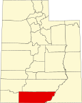
Kane County is a county in the U.S. state of Utah. As of the 2020 United States Census, the population was 7,667. Its county seat and largest city is Kanab...
16 KB (1,228 words) - 03:18, 29 September 2024

Kanab (/kəˈnæb/ kə-NAB) is a city in and the county seat of Kane County, Utah, United States. It is located on Kanab Creek just north of the Arizona state...
24 KB (2,340 words) - 05:55, 14 August 2024
league baseball team based in Kane County, Illinois Kane County, Utah All pages with titles containing Kane County This disambiguation page lists articles...
262 bytes (70 words) - 00:32, 15 December 2020

Buckskin Gulch (redirect from Buckskin Gulch (Utah))
Wash, and Kaibab Gulch) is a gulch and canyon located in southern Kane County, Utah, near the Arizona border in the Paria Canyon-Vermilion Cliffs Wilderness...
5 KB (450 words) - 03:10, 8 July 2024

Alton is a town in northwest Kane County, Utah, United States. The population was 119 at the 2010 census, a decrease from the 2000 figure of 134. Alton...
12 KB (472 words) - 01:14, 1 May 2024

Duck Creek Village is an unincorporated community in Kane County, Utah, United States. The community is located on the edge of Cedar Mountain, with an...
4 KB (84 words) - 04:53, 24 July 2023

Glendale is a town in Kane County, Utah, United States. The population was 381 at the 2010 census. Glendale was originally called "Berryville", and under...
10 KB (808 words) - 21:16, 6 June 2024

Orderville is a town in western Kane County, Utah, United States. The population was 577 at the 2010 census. The town was founded and operated under the...
16 KB (1,640 words) - 00:15, 13 May 2024
Kane County John Doe (1994) is an unidentified male whose remains were discovered near Big Water, Kane County, Utah, in February 1994. His death, estimated...
5 KB (592 words) - 20:58, 1 October 2024

Cottonwood Canyon is a canyon in central Kane County, Utah United States. The canyon is a water-carved canyon that has eroded along weak locations in...
2 KB (120 words) - 14:12, 1 April 2023
Kane Kane County, Utah, US Kane Mountain, mountain in Fulton County, New York Anoka County–Blaine Airport, Minnesota, US (ICAO airport code: KANE) Cape...
4 KB (488 words) - 19:59, 15 September 2024

Bryce Canyon National Park (redirect from Bryce Canyon National Park, Utah)
000 feet (2,400 to 2,700 m). The area is in portions of Garfield County and Kane County. The Bryce Canyon area was settled by Mormon pioneers in the 1850s...
38 KB (3,400 words) - 14:00, 4 October 2024

Lake Powell (category Lakes of Kane County, Utah)
primarily in parts of Garfield, Kane, and San Juan counties in southern Utah, with a small portion in Coconino County in northern Arizona. The northern...
32 KB (3,364 words) - 19:51, 10 July 2024

Coyote Gulch (category Rivers of Kane County, Utah)
a tributary of the Escalante River, located in Garfield and Kane Counties in southern Utah, in the western United States. Over 25 mi (40 km) long, Coyote...
9 KB (952 words) - 03:46, 18 October 2024
Pink Cliffs (category Landforms of Kane County, Utah)
dissected cliffs on the Colorado Plateau in Garfield, Iron, and Kane counties in southwestern Utah, United States. Contrary to the implication of the name, the...
6 KB (590 words) - 21:05, 17 March 2024
The Long Valley of Utah is a 13-mile (21 km) long valley located in western Kane County. The valley is located in source water regions of waters flowing...
13 KB (759 words) - 15:49, 5 April 2023

Coyote Buttes (category Landforms of Kane County, Utah)
(BLM), spanning extreme south-central Utah and north-central Arizona, south of US 89 halfway between Kanab, Utah and Page, Arizona. It is divided into...
4 KB (328 words) - 04:13, 16 September 2021
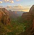
Zion National Park (redirect from Zion National Park, Utah)
The park is located in southwestern Utah mostly in unincorporated areas in Washington, Iron, and Kane counties. The territory of Springdale extends into...
60 KB (5,565 words) - 03:37, 3 October 2024

establish Kane, Pennsylvania. He died of pneumonia in 1883. Both Kane County, Utah, and Kanesville Tabernacle are named for Kane. The Kane Historic Preservation...
40 KB (4,788 words) - 14:40, 20 April 2024

Paria River in Grand Staircase–Escalante National Monument in central Kane County, Utah, United States. It was inhabited from 1870 to 1929, and later used...
7 KB (764 words) - 20:18, 27 September 2024
(West Des Moines, Iowa) Valley School (Orderville, Utah), listed on the NRHP in Kane County, Utah This disambiguation page lists articles associated with...
276 bytes (60 words) - 03:48, 13 August 2021

than 10 miles (16 km) from Glen Canyon Dam. It is located within Kane County, Utah, United States. Facing Lone Rock is the Lone Rock Campground accessed...
2 KB (207 words) - 18:26, 21 April 2021

Glen Canyon (category Landforms of Kane County, Utah)
9 km) length of the Colorado River, mostly in southeastern and south-central Utah, in the United States. Glen Canyon starts where Narrow Canyon ends, at the...
17 KB (2,129 words) - 09:39, 13 May 2024

Moqui Cave (category Landforms of Kane County, Utah)
Moqui Cave is a sandstone erosion cave in southern Utah, United States. It is located roughly 5 miles (8.0 km) north of Kanab, along U.S. Route 89. The...
7 KB (669 words) - 10:22, 18 April 2024
(Arizona-Utah)–Coconino County -- (S. Kane County, Utah) Butler Mountains–Yuma County Cabeza Prieta Mountains–Yuma County Camelback Mountain– Maricopa County Canelo Hills–Santa...
35 KB (2,963 words) - 23:51, 24 September 2024

Zion – Mount Carmel Highway (category National Register of Historic Places in Kane County, Utah)
Carmel Highway is a 25-mile (40 km) long road in Washington and Kane counties in southern Utah, United States, that is listed on the National Register of Historic...
10 KB (1,090 words) - 20:51, 12 February 2024

Vermilion Cliffs (category Landforms of Kane County, Utah)
southern Utah in the southwestern United States. They extend west from near Page, Arizona, for a considerable distance, in both Arizona and Utah. 112,500...
4 KB (482 words) - 20:48, 17 March 2024

Hole in the Rock Trail (category Transportation in Kane County, Utah)
Garfield County, Utah National Register of Historic Places listings in Kane County, Utah National Register of Historic Places listings in San Juan County, Utah...
7 KB (629 words) - 17:02, 13 May 2024

Paunsaugunt Plateau (category Landforms of Kane County, Utah)
100–2,800 m), in southwestern Utah in the United States. Located in northern Kane County and southwestern Garfield County, it is approximately 10 miles...
3 KB (298 words) - 14:37, 4 August 2024

Coral Pink Sand Dunes State Park (category Landforms of Kane County, Utah)
in southwestern Utah, United States, located between Mount Carmel Junction and Kanab, south and west of U.S. Highway 89 in Kane County. The park features...
6 KB (397 words) - 05:11, 7 December 2023