William Hand Browne, Louis Henry Dielman Maryland Historical Society (1956). Maryland Historical Magazine. p. 213. "Town Center", towncenter.columbiavillages...
33 KB (30 words) - 18:53, 14 March 2022

Howard County is a county located in the U.S. state of Maryland. As of the 2020 census, the population was 334,529. Since there are no incorporated municipalities...
85 KB (5,302 words) - 00:27, 10 August 2024
following are major and notable roads in Baltimore County, Maryland. Maryland portal List of streets in Baltimore, Maryland Linda Martinak, M.; Sutherland...
61 KB (206 words) - 20:58, 16 June 2024
The Howard County Public School System (HCPSS) is the school district that manages and runs the public schools of Howard County, Maryland. It operates...
104 KB (10,166 words) - 16:10, 8 August 2024

Maryland State Roads Commission (1953). Maryland: Official Highway Map (PDF) (Map). Baltimore: Maryland State Roads Commission. Maryland State Roads Commission...
66 KB (7,616 words) - 00:58, 5 August 2024

Anne Arundel County (listen; /əˈrʌndəl/), also notated as AA or A.A. County, is a county located in the U.S. state of Maryland. As of the 2020 United States...
58 KB (4,385 words) - 20:04, 29 July 2024

community and census-designated place in, and the county seat of, Howard County, Maryland, United States. Part of the Baltimore metropolitan area, its...
72 KB (7,023 words) - 22:57, 17 July 2024

2010-11-29. Maryland State Roads Commission (May 1915). Report of the State Roads Commission of Maryland (1912–1915 ed.). Baltimore: Maryland State Roads Commission...
47 KB (3,804 words) - 01:12, 5 August 2024

Montgomery County is the most populous county in the U.S. state of Maryland. As of the 2020 census, the county's population was 1,062,061, increasing...
111 KB (7,735 words) - 19:36, 17 July 2024

County (often shortened to PG County or PG) is a county located in the U.S. state of Maryland bordering the eastern portion of Washington, D.C. As of...
116 KB (9,551 words) - 00:18, 15 August 2024

and census-designated place in Howard and Anne Arundel counties, about 15 miles (24 km) southwest of Baltimore, Maryland, United States. Per the 2020...
21 KB (1,887 words) - 21:42, 6 May 2024

state of Maryland. It is part of the Baltimore metropolitan area. Baltimore County partly surrounds but does not include the independent city of Baltimore...
66 KB (6,125 words) - 21:20, 18 June 2024

in the U.S. state of Maryland runs from Garrett County in Western Maryland to Cecil County in the state's northeastern corner. With a total length of...
80 KB (7,537 words) - 01:43, 5 August 2024
Clarksville is an unincorporated community in Howard County, Maryland; the second highest-earning county in the United States according to the U.S. Census...
8 KB (756 words) - 22:40, 19 April 2024

Carroll County is a county located in the U.S. state of Maryland. As of the 2020 census, the population was 172,891. Its county seat is Westminster. Carroll...
51 KB (4,095 words) - 21:20, 18 June 2024
Dead end north of Candice Drive to Ridge Road (in Howard County) Mt. Airy Main Street (New Windsor) Springdale Road to Old Windsor Road New Windsor Main...
11 KB (0 words) - 18:37, 21 March 2022
State Roads Commission. Maryland Geological Survey (1935). Map of Maryland Showing State Road System: State Aid Roads and Improved County Road Connections...
86 KB (9,107 words) - 23:20, 15 May 2024

census-designated place (CDP) in Howard County, Maryland, United States. The population was 15,593 at the 2010 census. Founded early in the 18th century, Elkridge...
35 KB (3,558 words) - 22:24, 4 July 2024
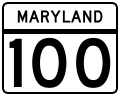
with MD 10 and MD 607. The road ends by merging back into MD 177. Maryland Route 100 began in the 1970s as two separate roads, both having the MD 100 designation...
22 KB (1,289 words) - 02:20, 29 March 2024

census-designated place in Baltimore County, Maryland. Per the 2020 census, the population was 39,986. It is home to the headquarters of the Social Security...
13 KB (953 words) - 23:17, 3 August 2024

Maryland Route 27 (MD 27) is a state highway in the U.S. state of Maryland. Known for most of its length as Ridge Road, the highway runs 39.17 miles (63...
29 KB (3,435 words) - 01:14, 5 August 2024

(1927). Map of Maryland: Showing State Road System and State Aid Roads (PDF) (Map). Baltimore: Maryland Geological Survey. Maryland State Roads Commission...
22 KB (2,688 words) - 22:12, 4 August 2024

Columbia is a census-designated place in Howard County, Maryland, United States. It is a planned community consisting of 10 self-contained villages. The census-designated...
78 KB (7,919 words) - 21:51, 9 August 2024

Howard County Library System (HCLS), established in 1940, is a public library system located in central Maryland. HCLS delivers equal opportunity in education...
8 KB (959 words) - 14:59, 14 November 2023

community in Howard, Carroll and Baltimore counties, Maryland, United States. Marriottsville is located along Marriottsville Road near the Carroll County line...
6 KB (440 words) - 18:19, 15 July 2024
following is a list of state highways in Maryland shorter than one mile (1.6 km) in length with route numbers between 700 and 799. Most of these highways...
48 KB (3,564 words) - 02:44, 5 May 2024
plantation in Glenwood in Howard County, Maryland, United States. The Longwood plantation was started by Dr. Gustavus Warfield (1784-??), son of Dr. Charles...
4 KB (393 words) - 18:43, 24 April 2024

Interstate 895 (redirect from Interstate 895 in Maryland)
Maryland State Roads Commission (1962). Maryland: Official Highway Map (PDF) (Map). Baltimore: Maryland State Roads Commission. Maryland State Roads Commission...
33 KB (3,676 words) - 01:00, 5 August 2024

authors list (link) Maryland State Roads Commission (1939). General Highway Map: State of Maryland (PDF) (Map). Baltimore: Maryland State Roads Commission...
34 KB (3,443 words) - 22:14, 4 August 2024

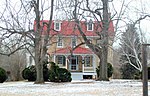
Glenwood, Howard County, Maryland, United States. It is a rectangular two-story building of stuccoed stone construction painted pastel yellow completed in 1833...
3 KB (232 words) - 21:45, 24 May 2022