
its antenna motor ended QuikSCAT's capabilities to determine useful surface wind information on 23 November 2009. The QuikSCAT geophysical data record...
26 KB (2,889 words) - 18:41, 4 July 2024
MIPAS MISR MODIS MOPITT MTSAT NMP NOAA-N' NPOESS OMI OCO PARASOL QuickBird QuikSCAT RADARSAT-1 SCIAMACHY SeaWiFS SORCE SPOT TES Terra TRMM ERS Nimbus program...
4 KB (260 words) - 21:25, 1 July 2024

Kumar (2014). "Cross Calibration of the OceanSAT -2 Scatterometer With QuikSCAT Scatterometer Using Natural Terrestrial Targets". Research Gate. Retrieved...
19 KB (1,470 words) - 19:02, 29 June 2024
TWTA instrument failure occurred on 28 February 2021. Spaceflight portal QuikSCAT Oceansat-1 Oceansat-2 "Special Section: SCATSAT-1". Nair, Avinash (27 May...
8 KB (651 words) - 22:06, 21 October 2023
reconnaissance aircraft flight into the storm found no circulation, while a QuikSCAT pass indicated an open wave. As a result, Chris dissipated while east of...
91 KB (9,054 words) - 21:36, 20 June 2024

McFadden (April 2005). "Hurricane Force Extratropical Cyclones Observed Using QuikSCAT Near Real Time Winds". Mariners Weather Log. 49 (1). Voluntary Observing...
87 KB (9,338 words) - 06:43, 6 July 2024

Archived from the original on 4 October 2008. Retrieved 10 August 2017. "QuikSCAT". Winds.jpl.nasa.gov. Archived from the original on 14 January 2013. Retrieved...
38 KB (1,190 words) - 04:45, 1 July 2024

removed from the center. Early on September 23, both satellite estimates and QuikScat data determined that the depression had strengthened into Subtropical Storm...
90 KB (7,591 words) - 07:27, 4 July 2024

Mission (precipitation radar, 1997-2015) JERS-1 (SAR, Japan, 1998-2001) QuikSCAT (scatterometer, United States, 1999-2008) Shuttle Imaging Radar on the...
10 KB (1,334 words) - 15:00, 22 December 2023

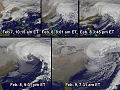
QuikSCAT image showing the speed of the Santa Ana winds (m/s)...
38 KB (4,442 words) - 22:20, 4 May 2024

swath 900 km wide (560 mi). The ISS-RapidScat program was initiated in response to the failure of the QuikSCAT satellite's antenna rotation mechanism in...
12 KB (1,133 words) - 07:07, 27 February 2023

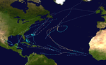
1, 2011. Retrieved May 6, 2009. Chavas, D.R.; Emanuel, K.A. (2010). "A QuikSCAT climatology of tropical cyclone size". Geophysical Research Letters. 37...
210 KB (20,549 words) - 10:43, 13 July 2024

QuikSCAT image of typical extratropical cyclones over the ocean. Note the maximum winds are on the outside of the occlusion....
58 KB (6,061 words) - 03:32, 20 June 2024

1999. It was followed up by three other EOS satellites: Terra, Aqua and QuikSCAT. To ensure a sustainable financing of operations, NSC started negotiating...
29 KB (3,009 words) - 23:25, 8 May 2024

Indian Ocean, Monsoon, and Somali Current using NASA's AIRS, MODIS, and QuikSCAT data" Archived 2008-09-17 at the Wayback Machine. NASA Goddard Earth Sciences...
8 KB (1,028 words) - 07:39, 15 August 2023
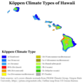
around the Hawaiian Islands measured by the Seawinds instrument aboard QuikSCAT during August 1999. Trade winds blow from right to left in the image. The...
29 KB (2,681 words) - 22:26, 11 March 2024

the GOES series from the 1970s onward. Polar orbiting satellites such as QuikScat and TRMM began to relay wind information near the ocean's surface starting...
30 KB (3,457 words) - 16:29, 2 July 2024
instrument on QuikSCAT (2001–2009) OSCAT-2 instrument on SCATSAT-1 (launched 2016) SCAT instrument on Oceansat-2 (2009–2014) ISS-RapidScat on the International...
11 KB (1,449 words) - 04:53, 8 June 2024
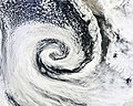
QuikSCAT image of typical extratropical cyclones over the ocean. Note the maximum winds on the poleward side of the occluded front....
34 KB (3,289 words) - 12:54, 22 June 2024
Earth-orbiting satellites such as TOPEX/Poseidon, and scatterometers on ADEOS I, QuikSCAT, and Jason-1. On the 35th anniversary of Seasat's launch, the Alaska Satellite...
11 KB (815 words) - 20:32, 6 June 2024
McFadden (April 2005). "Hurricane Force Extratropical Cyclones Observed Using QuikSCAT Near Real Time Winds". Mariners Weather Log. 49 (1). Retrieved 2009-10-26...
26 KB (2,892 words) - 13:47, 8 July 2024

space radio stations dedicated to the radiodetermination-satellite service QuikSCAT-Satellite, with Wind-profiling-radar OSTM-06-Satellite, with High-altimeter-radar...
8 KB (734 words) - 04:16, 24 March 2024
Niño links as detected by a decade of QuikSCAT, TRMM and TOPEX/Jason Observations From El Nino to Atlantic Nino: pathways as seen in the QuikScat winds...
14 KB (1,666 words) - 03:50, 4 January 2024
Cloud and Land Elevation Satellite (ICESat) Quick Scatterometer Mission (QuikSCAT) TIMED (Thermosphere Ionosphere Mesosphere Energetics and Dynamics) Solar...
5 KB (541 words) - 23:38, 27 April 2024

evident using visible satellite, shortwave infrared, microwave imagery or QuikSCAT/Windsat ambiguities 3 points A circulation has been evident for at least...
9 KB (664 words) - 01:04, 4 June 2023

NASA's MODIS and QuikSCAT satellite data from 2007 were compared to confirm the precision of different melt observations....
163 KB (16,913 words) - 02:07, 5 July 2024

circulation center. However, around 0900 UTC on August 26, satellite imagery and QuikSCAT data indicated that a closed low had formed. While situated about 430 mi...
15 KB (1,488 words) - 14:11, 23 February 2024

advent of new technologies. These technologies include satellite-derived Quikscat winds, satellite-derived temperature profile information, and Robert Hart's...
17 KB (1,706 words) - 03:43, 29 January 2024

carried out through this program include SeaWiFS (1997), Landsat 7 (1999), QuikSCAT (1999), Jason 1 (2001), GRACE (2002), Aqua (2002), Aura (2004) and Aquarius...
95 KB (8,967 words) - 19:14, 3 July 2024

QuikSCAT image from 2002 showing the speed of the Santa Ana winds (m/s)...
86 KB (7,362 words) - 07:24, 4 July 2024