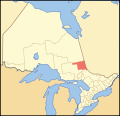
This is a list of secondary highways in Cochrane District, most of which serve as logging roads, mine and dam access roads, or provide access to isolated...
18 KB (1,354 words) - 10:20, 11 August 2022
is a list of secondary highways in Kenora District, most of which provide access to isolated and sparsely populated areas in the Kenora District of northwestern...
30 KB (2,153 words) - 02:37, 7 July 2023
This is a list of secondary highways in Timiskaming District, most of which serve as logging roads or provide access to the isolated and sparsely populated...
17 KB (982 words) - 16:49, 10 April 2023
This is a list of secondary highways in Thunder Bay District, most of which serve as logging roads or provide access to the isolated and sparsely populated...
30 KB (1,905 words) - 15:53, 3 September 2023
This is a list of secondary highways in Manitoulin District, which serve the isolated and sparsely populated areas in the Manitoulin District of Ontario...
11 KB (764 words) - 00:18, 19 June 2024
is a list of secondary highways in Rainy River District, most of which serve isolated and sparsely populated areas in the Rainy River District of northwestern...
8 KB (525 words) - 15:52, 3 September 2023
a list of secondary highways in Algoma District, most of which serve as logging roads or provide access to isolated and sparsely populated areas in the...
35 KB (2,703 words) - 03:04, 20 June 2024
This is a list of secondary highways in Parry Sound District, many of which provide access to isolated settlements and recreational properties within...
25 KB (1,585 words) - 21:30, 1 September 2022
a list of secondary highways in Sudbury District, most of which serve as logging roads or provide access to provincial parks and isolated areas in the...
7 KB (491 words) - 20:51, 31 March 2022
This is a list of secondary highways in Nipissing District, many of which serve as logging roads or provide access to Algonquin Park and sparsely populated...
13 KB (782 words) - 22:20, 31 March 2021

Highway 655 is a secondary highway in the Cochrane District in Northern Ontario. The route is 74.7 kilometres (46.4 mi) in length. It is heavily used by...
6 KB (453 words) - 20:32, 12 May 2021

Timiskaming District, just outside Timmins. The Sudbury District also has a number of secondary provincial highways, which are the analogue in a district to county...
12 KB (958 words) - 22:03, 7 May 2024
Provincial highways in Ontario include all roads maintained by the Ministry of Transportation as part of the Ontario Provincial Highway Network. Although...
118 KB (2,499 words) - 00:21, 19 June 2024
Sudbury districts. In 1921, Cochrane District was created from parts of this district and parts of Thunder Bay District. The division had a population of 32...
12 KB (509 words) - 04:01, 7 January 2024

Northeastern Ontario (category Geography of Northern Ontario)
consists of the districts of Algoma, Sudbury, Cochrane, Timiskaming, Nipissing and Manitoulin. For some purposes, Parry Sound District and Muskoka District Municipality...
10 KB (466 words) - 16:00, 18 September 2023
"Provincial Highways Distance Table". Provincial Highways Distance Table: King's Secondary Highways and Tertiary Roads. Ministry of Transportation of Ontario:...
131 KB (9,529 words) - 22:24, 9 June 2024
as part of the King's Highway, secondary highways, and tertiary roads. Components of the system—comprising 16,900 kilometres (10,500 mi) of roads and...
119 KB (11,363 words) - 08:06, 29 May 2024
terminus of Secondary Highway 650. The route winds north, crossing the railway line before ending at Highway 66, part of the Trans-Canada Highway, between...
6 KB (490 words) - 15:45, 22 May 2024

Highway 634, as noted by the Ministry of Transportation of Ontario. The entire route is located in Cochrane District. Ministry of Transportation of Ontario...
7 KB (643 words) - 17:05, 20 June 2024
8 km (6.1 mi), located entirely within Cochrane District. The highway begins at Highway 11 just northwest of Porquis Junction, travelling east and immediately...
9 KB (813 words) - 18:34, 25 April 2024
Arthur Wray (category All Wikipedia articles written in Canadian English)
impassable outside of the town. Fallow refused to give any priority to Cochrane and said the government does not clear secondary highways. He dismissed a...
6 KB (614 words) - 04:25, 20 January 2023

Ontario) DR = District Road (only in Muskoka; similar routes in unincorporated districts are usually provincial Secondary or Tertiary Highways) MR = Municipal...
9 KB (551 words) - 15:21, 23 June 2024
Remi Lake (category Lakes of Cochrane District)
is a lake in both the municipality of Moonbeam and geographic Gurney Township in Unorganized North Cochrane District, Cochrane District, in Northeastern...
5 KB (260 words) - 00:35, 6 December 2022

Smooth Rock Falls (category Municipalities in Cochrane District)
Rock Falls is an incorporated town in the Cochrane District in Northeastern Ontario, Canada, with a population of 1,330 at the 2016 census. The town lies...
11 KB (927 words) - 23:09, 7 January 2024
numerous highways to municipal government bodies, renumbered them, or upgraded them to 400-series highways. In 1997 and 1998, many sections of the provincial...
34 KB (3,672 words) - 21:30, 27 May 2024

and Cochrane district, connecting Highway 66 — part of the Trans-Canada Highway — in the south with Highway 101 in the north. It is the only highway to...
6 KB (503 words) - 20:33, 12 May 2021

400-series highways Former provincial highways in Ontario County roads in Ontario List of Ontario Tourist Routes Education in Ontario Primary education in Ontario...
65 KB (1,758 words) - 17:34, 23 May 2024
limit. Highway 144 was created by renumbering Highway 544 in April 1965. This was done in preparation for an extension of the short secondary highway from...
15 KB (1,237 words) - 16:28, 20 June 2024
Ontario (redirect from Transport in Ontario)
busiest highway in North America. Other provincial highways and regional roads inter-connect the remainder of the province, and the Trans-Canada Highway connects...
163 KB (13,511 words) - 23:11, 26 June 2024

Hearst, Ontario (category Municipalities in Cochrane District)
Hearst is a town in the district of Cochrane, Ontario, Canada. It is located on the Mattawishkwia River in Northern Ontario, approximately 92 kilometres...
16 KB (937 words) - 18:09, 28 May 2024