Surveying or land surveying is the technique, profession, art, and science of determining the terrestrial two-dimensional or three-dimensional positions...
57 KB (7,282 words) - 07:24, 12 March 2025
Look up survey in Wiktionary, the free dictionary. Survey may refer to: Survey (human research), including opinion polls Surveying, the technique and science...
968 bytes (163 words) - 20:13, 11 December 2024

benchmarks using a handheld GPS receiver. Broad arrow Geoid Levelling—a surveying technique that uses benchmarks Ordnance datum Spot height "Bench marks...
10 KB (1,053 words) - 15:42, 10 February 2025
Environmental surveying is the title of a profession within the wider field of surveying, the practitioners of which are known as environmental surveyors...
8 KB (1,027 words) - 10:20, 24 March 2025

In surveying, triangulation is the process of determining the location of a point by measuring only angles to it from known points at either end of a...
12 KB (1,606 words) - 00:32, 29 February 2024
Instruments used in surveying include: Alidade Alidade table Cosmolabe Dioptra Dumpy level Engineer's chain Geodimeter Graphometer Groma (surveying) Laser scanning...
2 KB (129 words) - 19:19, 4 October 2023

sometimes croma, or gruma in the literature of the republican times) was a surveying instrument used in the Roman Empire. The groma allowed projecting right...
8 KB (995 words) - 23:17, 21 February 2025

Geomatics (redirect from Surveying engineering)
navigation satellite system (GNSS) Surveying (including land, cadastral, aerial, mining and engineering surveying) Hydrography Navigation Location-based...
18 KB (1,720 words) - 18:19, 14 February 2025
Construction surveying or building surveying (otherwise known as "staking", "stake-out", "lay-out", or "setting-out") is to provide dimensional control...
17 KB (2,019 words) - 07:37, 30 January 2024
Civil engineering surveying, a survey of local topographic features for engineering purposes Cadastral surveying, the surveying of specific land parcels to...
718 bytes (118 words) - 05:50, 16 October 2018

Erie) that serves as a reference line for surveying a grid of property lots. The result of this surveying is the concession road and sideline system...
6 KB (724 words) - 18:13, 19 February 2025

In U.S. land surveying under the Public Land Survey System (PLSS), a section is an area nominally one square mile (2.6 square kilometers), containing 640...
13 KB (1,651 words) - 19:27, 20 March 2025

contribution to hydrographic surveying during much of the rest of the 20th century. So valuable was wire-drag surveying in the United States that for...
34 KB (4,119 words) - 22:55, 3 October 2024
Cadastral surveying is the sub-field of cadastre and surveying that specialises in the establishment and re-establishment of real property boundaries....
7 KB (966 words) - 12:41, 26 March 2025
Surveying in Oceania may refer to: Surveying in Australia Surveying in New Zealand This disambiguation page lists articles associated with the title Surveying...
146 bytes (46 words) - 07:01, 9 February 2019
Pacing is a reasonably easy and quick method of measuring distance in the field. It is used to measure a distance and is often used with a sighting or...
2 KB (247 words) - 03:59, 27 January 2025
method in the field of surveying to establish control networks. It is also used in geodesy. Traverse networks involve placing survey stations along a line...
4 KB (474 words) - 20:49, 14 May 2024
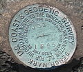
Benchmark (surveying), a surveying mark used as a reference point in measuring altitudes Boundary marker Milestone Triangulation station, a surveying mark used...
10 KB (1,244 words) - 18:30, 29 November 2023
Polish Mine Surveying Committee (PK-ISM) Institute of Mine Surveyors of South Africa (IMSSA) Surveying Land subsidence geological survey spatial sciences...
1 KB (83 words) - 22:10, 28 September 2023

land. In modern land law and surveying a gore is a strip of land, usually triangular in shape, as might be left between surveys that do not close. In some...
5 KB (369 words) - 15:03, 22 June 2024
Quantity surveyor (redirect from Quantity Surveying)
standard Quantity Surveying degree and develop Quantity Surveying skills through their own training programmes. The future of quantity surveying lies in embracing...
6 KB (668 words) - 17:15, 16 March 2025

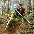
surveyor's tripod is a device used to support any one of a number of surveying instruments, such as theodolites, total stations, levels or transits....
4 KB (642 words) - 20:51, 20 December 2022

Domesday Book (redirect from Domesday survey)
English spelling of "Doomsday Book") is a manuscript record of the Great Survey of much of England and parts of Wales completed in 1086 at the behest of...
45 KB (5,446 words) - 13:19, 26 March 2025

In surveying, a pole is bar made of wood or metal and normally held vertical, upon which different instruments can be mounted: a prism, a GPS device,...
1 KB (114 words) - 23:25, 29 March 2024
Metrology and Surveying of Austria (German: Bundesamt für Eich- und Vermessungswesen, BEV) is the body responsible for official surveying, geo-information...
7 KB (250 words) - 21:22, 24 March 2025

Intergovernmental Committee on Surveying and Mapping (ICSM) ANZLIC Mapping Sciences Institute, Australia Surveying Surveying in New Zealand Surveyor General...
9 KB (866 words) - 11:07, 6 March 2024

Surveying in North America is heavily influenced by the United States Public lands survey system. It inherits the basis of its land tenure from the United...
7 KB (855 words) - 20:07, 21 February 2024
Survey of Pakistan (Urdu: مساحتِ پاکستان, romanized: masāhat-e-pākistān) is the sole national mapping and land surveying government agency of Pakistan...
5 KB (441 words) - 14:16, 12 March 2025

Geodesy (redirect from Geodetic surveying)
practical applications of geodesy on local and regional scales, including surveying. In German, geodesy can refer to either higher geodesy (höhere Geodäsie...
40 KB (4,385 words) - 18:37, 6 February 2025

The Survey of India is India's central engineering agency in charge of mapping and surveying. Set up in 1767 to help consolidate the territories of the...
14 KB (1,177 words) - 16:21, 1 April 2025