
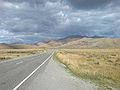
The Ōhau River is a river in the Mackenzie Basin of New Zealand's South Island. It is the primary outflow of Lake Ōhau, from which it flows in a roughly...
4 KB (249 words) - 21:12, 22 July 2024
Ōhau River may refer to two watercourses in New Zealand: Ōhau River (Canterbury) Ōhau River (Manawatū-Whanganui) This disambiguation page lists articles...
145 bytes (51 words) - 21:29, 5 March 2023
Island Ben Ohau Range Ōhau (skifield) Lake Ōhau Lake Ohau Alpine Village Ōhau River (Canterbury) Ōhau A power station Ōhau B power station Ōhau C power station...
707 bytes (119 words) - 03:26, 6 August 2024

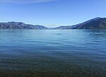
Lake Ōhau is a lake in the Mackenzie Basin in the South Island of New Zealand. The Hopkins and Dobson rivers fed into the northern end of Lake Ōhau. These...
31 KB (3,533 words) - 20:36, 22 July 2024

which meets the Ohau Canal from Lake Ōhau into Ōhau A station and Lake Ruataniwha. The Ohau Canal continues beyond Lake Ruataniwha to Ōhau B midway along...
10 KB (945 words) - 13:05, 26 July 2024

Lake Ōhau in the Mackenzie Country. Its headwaters, on the southern slopes of Mount Hopkins, form the northernmost point of Otago, and the river's braided...
5 KB (191 words) - 21:10, 22 July 2024
Ngatiawa River Ngunguru River Nina River Nokomai River North Barlow River North Mathias River North Ōhau River, Canterbury North Ōhau River, Wellington...
31 KB (2,843 words) - 05:08, 4 May 2024

joining with the Hopkins River, close to the latter's entry into the northern end of Lake Ōhau in the Mackenzie Country. The river flows over wide shingle...
4 KB (314 words) - 21:09, 22 July 2024
which meets the Ōhau Canal from Lake Ōhau into Ōhau A station and Lake Ruataniwha. The Ōhau Canal continues beyond Lake Ruataniwha to Ōhau B midway along...
12 KB (1,315 words) - 16:38, 18 December 2023

Pachystegia (redirect from Ōhau rock daisy)
Station and the Upper Awatere River valley. The most endangered is the Ōhau rock daisy, an undescribed species found only on Ōhau Point north of Kaikōura....
5 KB (516 words) - 02:27, 28 July 2024

-44; 170 and east of the Dobson river and Lake Ōhau. The Ben Ohau range is dominated at the southern end by Ben Ohau (1522m). Other mountains in the range...
2 KB (183 words) - 20:44, 22 July 2024

Lake Ruataniwha (category Lakes of the Canterbury Region)
bed of the Ōhau River. The lake functions as a surge reservoir for the power scheme. If, during excessive inflows into Lake Ōhau which Ōhau A is unable...
9 KB (1,152 words) - 20:36, 22 July 2024
The Twizel River is a river of the Mackenzie Basin, in the Canterbury region of New Zealand's South Island. It is part of the Waitaki River system. It...
2 KB (161 words) - 21:14, 22 July 2024
Mackenzie Basin (category Landforms of the Canterbury Region)
the Waitaki River. Prominent rivers crossing the Mackenzie Basin include the Ahuriri, the Hakataramea and the Tekapo Rivers. Lakes Ōhau, Pukaki, Alexandrina...
14 KB (1,507 words) - 20:38, 22 July 2024

Lake Pukaki (category Lakes of the Canterbury Region)
end, into the Pukaki River. The outflow has been dammed, and canals carry water from Lake Pukaki and Lake Ōhau through the Ōhau A power station to Lake...
15 KB (1,336 words) - 20:36, 22 July 2024

North East Island Farmer Rocks Moekawa / South West Island Princes Islands Ōhau / West Island The New Zealand Subantarctic Islands are designated as a World...
30 KB (1,787 words) - 19:18, 12 September 2024
Meridian Energy (section Project River Recovery)
at between $1.50 and $1.80 Hydro Wind Manapouri Benmore Aviemore Ohau A Ohau B Ohau C Waitaki Te Āpiti Te Uku West Wind White Hill Meridian Energy owns...
30 KB (2,399 words) - 02:05, 27 July 2024

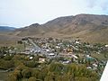
Twizel (category Populated places in the Canterbury Region)
Ōhau Lodge. This section is of an easy skill level, with little traffic. Points along the stage include the Pukaki and Ohau canals, views of Ben Ohau...
45 KB (4,339 words) - 06:15, 4 October 2024

the Canterbury and Otago regions of the South Island of New Zealand. It straddles the traditional border between the two regions, the Waitaki River, and...
14 KB (1,002 words) - 06:19, 4 October 2024
Dobson Mount Hutt Mount Lyford Mount Potts (heliskiing and snowcatting only) Ōhau Porters Ski Area Roundhill Tasman Glacier (Heliski) Temple Basin (club skifield)...
2 KB (125 words) - 07:27, 25 July 2024
Omarama (category Populated places in the Canterbury Region)
minutes drive) southwest of Twizel, 40 km (30 minutes drive) southeast of Lake Ōhau and 32 km (21 minutes drive) northeast of the Lindis Pass. Omarama is primarily...
20 KB (1,944 words) - 20:40, 11 August 2024

Manapouri Benmore Clyde Maraetai Roxburgh Tokaanu Rangipo Aviemore Ohau A Ohau B Ohau C Arapuni Tekapo B Ohakuri Waitaki Whakamaru Tararua West Wind Map...
65 KB (1,258 words) - 02:37, 6 October 2024

Benmore Dam (category Buildings and structures in the Canterbury Region)
the Twizel sub-station, with one circuit going via Ōhau C power station and one circuit going via Ōhau B power station. A single-circuit line to Islington...
9 KB (927 words) - 20:20, 22 July 2024

Lake Tekapo (category Lakes of the Canterbury Region)
in the South Island of New Zealand (the others are Lake Pukaki and Lake Ōhau). It covers an area of 83 km2 (32 sq mi) and is at an altitude of 710 m (2...
24 KB (2,186 words) - 00:07, 8 October 2024

Lake Pukaki Lake Ruataniwha, one of New Zealand's main rowing venues Lake Ōhau Glaciers: Tasman Glacier Hooker Glacier Skifields: Fox Peak Mt Dobson Round...
14 KB (1,008 words) - 06:34, 4 October 2024

The Huxley River (Māori: Tairau) is in the South Island of New Zealand. It feeds into the Hopkins River which in turn feeds into Lake Ōhau. The first...
2 KB (229 words) - 14:23, 19 September 2024
Benmore Power Station (1965), Aviemore Dam (1968), and later Tekapo B, and Ōhau A, B and C. In the North Island, the Tongariro Power Scheme was completed...
18 KB (2,103 words) - 15:25, 14 August 2024
Lake Benmore (category Lakes of the Canterbury Region)
mainly by the Tekapo, Pukaki and Twizel rivers, and the Ohau Canal; and the Ahuriri Arm, fed mainly by the Ahuriri River. Immediately downstream is Lake Aviemore...
7 KB (453 words) - 20:35, 22 July 2024
Beach Foxton North Foxton South Waitarere Waikawa Miranui Donnelly Park Ōhau-Manakau Kawiu South Makomako Kawiu North Levin Central Tararua Shannon Queenwood...
62 KB (4,617 words) - 09:01, 19 August 2024

Toa / Clarence River to Kāi Tahu. Kāi Tahu continued to push south, conquering Kaikōura. By the 1730s, Kāi Tahu had settled in Canterbury, including Banks...
106 KB (9,660 words) - 23:25, 27 September 2024