
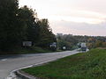
The A329 is an east–west road in Southern England that runs from Wentworth in Surrey to Thame in Oxfordshire. The A329 starts at the A30 in Surrey and...
3 KB (320 words) - 11:42, 15 July 2024
A329 may refer to: A329 road in Great Britain A329(M) motorway in Great Britain This disambiguation page lists articles associated with the title A329...
137 bytes (46 words) - 13:57, 27 December 2019

Streatley village. The Holies is also accessible (on foot only) from the A329 road south of Streatley, whilst Lough Down can be accessed from the ancient...
7 KB (590 words) - 17:21, 29 December 2023

The A329(M) is a motorway in Berkshire, England. It is 4 miles (6.4 km) long and runs from the west of Bracknell to the north west of Winnersh. It is one...
10 KB (930 words) - 13:54, 14 September 2024

roads in zone 3 in Great Britain starting west of the A3 and south of the A4 (roads beginning with 3). Wikimedia Commons has media related to A roads...
54 KB (56 words) - 23:53, 18 August 2024

independent school, Pangbourne College. Pangbourne is situated on the A329 road 6 miles (10 km) west of Reading, the nearest town, and 22 miles (35 km)...
11 KB (1,036 words) - 23:06, 25 September 2024

Cemetery Junction, Reading (category A4 road (England))
notorious bottleneck for traffic during rush hour, with the main A4 road meeting the A329 road from Wokingham. The junction is named after Reading Old Cemetery...
4 KB (317 words) - 15:27, 14 September 2023

List of A roads in zone 4 in Great Britain starting north of the A4 and south/west of the A5 (roads beginning with 4). Only roads that have individual...
70 KB (79 words) - 20:36, 17 September 2024

suburb. The railway line and station occupy a strip of land between the A329 road and the River Thames, with the up relief platform on an embankment above...
7 KB (641 words) - 21:14, 27 April 2024

Lower Basildon (section 6-12 Reading Road)
offers stopping trains between Didcot and London Paddington. The main A329 road connects the village with Goring and Reading. To the south-east of the...
6 KB (550 words) - 11:26, 23 April 2024
existing road, but the original retains the A road designation, for example A3(M), A329(M), A38(M), A48(M) and A627(M).[citation needed] B roads are numbered...
24 KB (2,997 words) - 14:42, 17 September 2024

Twyford Down, which generated a significant road protest. "Directions from A329 Reading Inner Distribution Road to A339 Basingstoke Ringway North". Google...
13 KB (747 words) - 19:52, 6 January 2024

Wallingford Road, was several hundred yards further up the main line towards Goring & Streatley, just east of the point where the A329 road crosses the...
9 KB (787 words) - 15:46, 29 May 2024

limited to navigation for leisure purposes, the gap accommodates the A329 road linking Reading and Oxford, along with the Great Western Main Line railway...
13 KB (1,859 words) - 12:19, 26 March 2024

the River Thame floodplain, about 250 feet (76 m) above sea level. The A329 road between Thame and Shillingford via Stadhampton passes through the village...
4 KB (305 words) - 21:24, 27 May 2024
The section from the B4009 underbridge west of Princes Risborough to the A329 level crossing west of Thame was subsequently converted into a footpath and...
12 KB (1,308 words) - 13:17, 5 September 2024

and High Wycombe. Beyond Stokenchurch the road is much quieter; when meeting the B4009 and A329 those roads have priority. Approaching Oxford, the A40...
50 KB (2,934 words) - 11:37, 2 September 2024

be reached on foot from Streatley, or by a track which comes off the A329 road to Wallingford. There was a flash lock recorded on the site in the 16th...
7 KB (709 words) - 20:05, 17 September 2024
part of the civil parish of Winkfield. The settlement lies near to the A329 road, and is situated approximately 1 mile (1.6 km) west of Ascot Racecourse...
2 KB (244 words) - 20:32, 6 July 2024
a major road in the south of England, portions of which are known as the Aldermaston Road, Tadley Hill, Basingstoke Road, and Tidmarsh Road. Starting...
2 KB (208 words) - 10:17, 21 March 2024
renumbered in 1935 – the section from Reading to Shillingford became part of the A329, Shillingford to Oxford became part of the A423 and Oxford to Birmingham...
6 KB (358 words) - 14:51, 14 September 2024

Bridge is Grade II* listed road bridge near Shillingford, Oxfordshire, carrying an unclassified road (formerly the A329 road) across the River Thames in...
12 KB (1,445 words) - 14:47, 16 April 2024
lies largely north of the A329 road and its borders begin immediately east of Bracknell town centre. The section between the A329 and the railway line, Bullbrook...
3 KB (256 words) - 18:14, 18 November 2023

south of the A329 road close to its junction with the A329(M) and near Great Hollands and Amen Corner. A new roundabout was built on the A329 for access...
6 KB (589 words) - 11:04, 10 July 2024

The A345 is a secondary A road in Wiltshire, England running from Salisbury to Marlborough and the A4. The road is a main south–north link across Salisbury...
4 KB (443 words) - 12:37, 11 January 2024

intersection with the A329 Cemetery Junction which links Wokingham with Pangbourne, passing the Royal Berkshire Hospital and the London Road Campus of the University...
57 KB (4,600 words) - 22:45, 25 October 2023

6 km) south-east of the town centre, to the east of the A322 road and south of the A329 road. It is part of the Harmans Water & Crown Wood ward. Facilities...
5 KB (473 words) - 20:40, 6 July 2024

Place' initiative. Most of the road is designated the A329. Reading West railway station is near the eastern end of Oxford Road. Tilehurst railway station...
8 KB (847 words) - 00:32, 3 June 2024

the construction of the A329(M). One of the main focal points of Winnersh is the Winnersh Crossroads where the Reading Road crosses King Street Lane...
9 KB (1,028 words) - 20:08, 13 September 2024
B roads are numbered routes in Great Britain of lesser importance than A roads. See the article Great Britain road numbering scheme for the rationale behind...
135 KB (82 words) - 16:10, 8 July 2024