
The A390 is a road in Cornwall and Devon, England. It runs from Tavistock to 5 miles (8.0 km) north west of the city of Truro. Starting in Tavistock, it...
4 KB (376 words) - 16:33, 23 March 2024
A390 may refer to: The A390 road, a main road in the United Kingdom The Lechner A-390, an Olympic sailboard class The RFA Wave Ruler (A390), a British...
255 bytes (69 words) - 13:48, 29 August 2014

roads in zone 3 in Great Britain starting west of the A3 and south of the A4 (roads beginning with 3). Wikimedia Commons has media related to A roads...
54 KB (56 words) - 15:45, 8 July 2024

England, United Kingdom. It is three miles (5 km) east of Truro on the A390 road. Tresillian means "a place of eels" in the Cornish language, according...
4 KB (425 words) - 22:41, 8 February 2024

The town is situated in the Fowey river valley, positioned between the A390 road from Tavistock to Truro and the upper tidal reaches of the river. Lostwithiel...
14 KB (1,383 words) - 22:43, 29 April 2024

Cornwall, England, about five miles (8.0 km) west of Liskeard along the A390 road. It consists of a small group of bungalows and houses. Hillball Wood is...
2 KB (104 words) - 09:21, 21 August 2022

is at an ancient crossing point of the River Fal and today is on the A390 road six miles (10 km) west of St Austell and eight miles (13 km) east of Truro...
15 KB (1,669 words) - 13:42, 13 July 2024

In July 2023, the construction of Fordh Langarth began. The road will link the A390 road through Langarth to the Royal Cornwall Hospital at Treliske....
5 KB (505 words) - 17:29, 7 February 2024

south of the A390 road. It was developed in the 1970s, with the construction of housing and an industrial estate to the north of the road. Since 1974,...
7 KB (816 words) - 09:24, 2 October 2023

in the Lyhner valley 2 miles (3.2 km) south-west of Callington off the A390 road, is also designated an SSSI for its biological interest. Cornwall portal...
5 KB (426 words) - 19:56, 27 January 2023

Hewas Water is a hamlet in mid Cornwall, England, UK. It is off the A390 road near Sticker and about 3 miles (5 km) west southwest of St Austell. It is...
696 bytes (75 words) - 23:11, 1 November 2022
Cornwall, England, UK. It is about two miles north of St Blazey on the A390 road. Cornwall portal Ordnance Survey: Landranger map sheet 200 Newquay & Bodmin...
669 bytes (78 words) - 10:39, 2 November 2022

near Nancor Farm; it was later set on a new shaft and erected beside the A390 road. In 1995 it was broken into four pieces but repaired in 1996. The fourth...
6 KB (802 words) - 19:53, 9 May 2023
station of Bere Alston. The most southerly road bridge across the Tamar in the Gunnislake area is the A390 road which makes the railway is the quickest way...
11 KB (958 words) - 19:45, 16 June 2024
West Taphouse is a hamlet in Cornwall, England. It is on the A390 road west of Middle Taphouse and East Taphouse. Cornwall portal Ordnance Survey get-a-map...
513 bytes (52 words) - 00:56, 21 March 2021

near Nancor Farm; it was later set on a new shaft and erected beside the A390 road. In 1995 it was broken into four pieces but repaired in 1996. The fourth...
84 KB (12,289 words) - 20:51, 8 June 2024

with the A390 and ends at Saltash when it meets the A38. The A388 at Polson near Lifton Polson Bridge Reader's Digest New Book of the Road. London: Reader's...
2 KB (132 words) - 20:15, 20 April 2024

The A39 is an A road in south west England. It runs south-west from Bath in Somerset through Wells, Glastonbury, Street and Bridgwater. It then follows...
8 KB (800 words) - 17:44, 26 January 2023

kilometres (1.9 mi) via the modern tarmac road to Tresillian Church (which replaced St Cohan's) and the A390 road, which connects Truro and St Austell. There...
7 KB (778 words) - 20:32, 9 May 2023

formerly served by the Probus and Ladock halt. It is also situated off the A390 road. Probus is served by local bus services between Truro and St Austell,...
10 KB (1,169 words) - 09:11, 9 October 2023

coast to Appledore on the north coast. The road starts in the centre of Plymouth, and forms Tavistock Road, the main route out of the city to the north...
3 KB (240 words) - 20:17, 20 April 2024
air. Broadcasting to Truro and mid-Cornwall, from a caravan next to the A390 road, Live 105 played a mixture of Dance and Rock, and was a first for radio...
64 KB (8,091 words) - 21:14, 8 June 2024
Buildings British Listed Buildings British Listed Buildings British Listed Buildings British Listed Buildings Wet Roads Devon British Listed Buildings...
13 KB (80 words) - 12:40, 9 April 2024

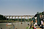
alongside the B3275, through Ladock to Tresillian, where it passes under the A390 road bridge, then immediately opens into a tidal estuary, and passes the village...
4 KB (361 words) - 18:43, 22 April 2024
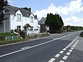
census was included in the civil parish of North Hill. Addington is on the A390 road from Liskeard to Callington and has its own post office and a fish and...
956 bytes (125 words) - 11:36, 25 April 2021

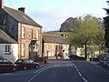
St Pinnock has always been in the Liskeard Registration District. The A390 road runs through the north of the parish. In the 1870s, St Pinnock was described...
10 KB (1,048 words) - 18:56, 14 August 2023

The road then follows the Semington bypass, opened in 2004, to Westbury, crossing the A361 between Trowbridge and Devizes. This section of the road has...
17 KB (1,766 words) - 10:00, 9 May 2024

The A345 is a secondary A road in Wiltshire, England running from Salisbury to Marlborough and the A4. The road is a main south–north link across Salisbury...
4 KB (443 words) - 12:37, 11 January 2024
The A381 road is a non-trunk 'A'-class road in Devon, England which serves as an important link between the towns of Teignmouth, Kingsteignton, Newton...
7 KB (672 words) - 11:42, 28 January 2023

park-and-ride scheme that serves the A390. The park-and-ride resulted in an estimated removal of 118,000 cars from the road during its first 9 months of operation...
4 KB (414 words) - 22:04, 5 October 2023