
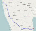
AH45 is a route of the National Highway Network of India, running 2,116 kilometres (1,315 mi) from in Kolkata to Krishnagiri. This route is composed of...
5 KB (305 words) - 17:31, 21 January 2024
Gwalior (AH47), Sagar, Nagpur (AH46), Hyderabad, Chikkaballapur and Bangalore (AH45, AH47), Madurai. The road briefly ends at Rameswaram before starting in Sri...
4 KB (290 words) - 10:45, 27 June 2023
Hubballi Haveri Ranebennur Harihar Davangere Chitradurga Tumkuru Bengaluru AH43 AH45 AH46 Economic and Social Commission for Asia and the Pacific, 2003 Asian...
3 KB (175 words) - 19:21, 28 June 2024

population is under 6 years of age. Gajuwaka is well connected by road. NH16 or AH45 passes through the Mandal. It also has major District roads and State Highways...
9 KB (498 words) - 23:10, 5 June 2024
National Highway 53 (India) Under old numbers, AH46 was part of old NH6 India. AH45 near Kharagpur, starting point. AH43 near Nagpur. AH47 near Dhule, end point...
3 KB (201 words) - 19:38, 28 June 2024

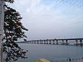
connecting the cities of Howrah and Chennai, a part of Asian Highway Network AH45. The district has a rail network of 406 km (252 mi). The entire rail network...
29 KB (2,297 words) - 18:46, 24 July 2024

mandal of Eluru revenue division. The nearest town is Tadepalligudem.The AH45 which runs from NH16 in Kolkata to NH48 in Bangalore passes by the village...
8 KB (673 words) - 00:13, 6 April 2024

of NH48 in red A stretch of NH 48 in 2016 Route information Part of AH43 AH45 AH47 Maintained by National Highways Authority of India Length 2,807 km (1...
12 KB (692 words) - 07:37, 28 April 2024
at Rajamahendravaram City on NH16 new alignment Route information Part of AH45 Length 1,711 km (1,063 mi) GQ: 1711 km (Chennai–Kolkata) Major junctions...
10 KB (547 words) - 06:47, 6 July 2024

under Phase 2A of Blue Line of Namma Metro General information Location AH45, Sector 6, Koramangala, Bengaluru, Karnataka 560034 Coordinates 12°54′59″N...
8 KB (257 words) - 02:42, 24 April 2024
4 (pre 2010) highlighted in solid blue colour Route information Part of AH45 AH47 Length 1,235 km (767 mi) Time period Pre 2010 Major junctions From Mumbai...
7 KB (609 words) - 06:01, 25 April 2024

under Phase 2A of Blue Line of Namma Metro General information Location AH45, Agara Village, 1st Sector, HSR Layout, Bengaluru, Karnataka 560034 Coordinates...
8 KB (264 words) - 02:42, 24 April 2024
National Highway 6 highlighted in solid blue color Route information Part of AH45 AH46 Length 1,949 km (1,211 mi) GQ: 117 km (73 mi) (Kolkata - Kharagpur)...
14 KB (971 words) - 18:08, 8 July 2024

IN AH44(A6) 107 km (67 miles) Dambulla, Sri Lanka Trincomalee, Sri Lanka AH45 2,030 km (1269 miles) Kolkata, India Krishnagiri, TN, IN (Via) Chennai, TN...
37 KB (2,161 words) - 23:56, 27 June 2024
AD44 — January 3, 2009 Kitt Peak Spacewatch · 670 m MPC · JPL 457593 2009 AH45 — January 15, 2009 Kitt Peak Spacewatch · 620 m MPC · JPL 457594 2009 AU47...
185 KB (301 words) - 18:49, 30 April 2024
10, 2009 Mount Lemmon Mount Lemmon Survey · 2.1 km MPC · JPL 547993 2010 AH45 — January 7, 2010 Mount Lemmon Mount Lemmon Survey · 800 m MPC · JPL 547994...
180 KB (301 words) - 18:57, 30 April 2024
2002 AO42 — January 9, 2002 Socorro LINEAR NYS 690 m MPC · JPL 194868 2002 AH45 — January 9, 2002 Socorro LINEAR NYS 1.6 km MPC · JPL 194869 2002 AH50 —...
177 KB (301 words) - 17:14, 30 November 2023
— December 13, 2010 Kitt Peak Spacewatch · 1.9 km MPC · JPL 695630 2016 AH45 — September 21, 2003 Kitt Peak Spacewatch · 1.9 km MPC · JPL 695631 2016...
178 KB (301 words) - 15:35, 7 June 2024
AE43 — January 4, 2001 Anderson Mesa LONEOS URS 7.5 km MPC · JPL 94186 2001 AH45 — January 15, 2001 Kleť Kleť Obs. · 7.9 km MPC · JPL 94187 2001 AF52 — January...
169 KB (301 words) - 17:29, 30 November 2023
2006 AL22 — January 5, 2006 Catalina CSS · 4.4 km MPC · JPL 248568 2006 AH45 — January 2, 2006 Mount Lemmon Mount Lemmon Survey · 3.8 km MPC · JPL 248569...
178 KB (301 words) - 11:26, 25 March 2024
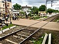
is a railway station, where passenger trains halt. The national highway AH45, state highway, main district road, and district road pass through the village...
10 KB (1,035 words) - 01:37, 6 April 2024
on all four sides. It is on the major road connecting Tanguturu (on NH5/AH45) to Kondapi. It is also connected directly to Ongole Via Nidamanuru & Kandukur...
7 KB (477 words) - 04:43, 6 April 2024
The following highways are numbered 45: AH45 Asian Highway 45 E45 European route E45 National Road 45 (Burma) Alberta Highway 45 Manitoba Highway 45 Ontario...
7 KB (483 words) - 23:14, 4 April 2024

BK7 22 January 1999 list (91330) 1999 HM2 20 April 1999 list (94186) 2001 AH45 15 January 2001 list (95072) 2002 AW66 15 January 2002 list (96355) 1997...
32 KB (458 words) - 01:22, 10 March 2023
2008 AG45 — January 10, 2008 Lulin LUSS · 2.7 km MPC · JPL 305315 2008 AH45 — January 10, 2008 Lulin LUSS · 1.3 km MPC · JPL 305316 2008 AR50 — January...
181 KB (301 words) - 16:59, 30 November 2023
5, 2013 Mount Lemmon Mount Lemmon Survey · 850 m MPC · JPL 491838 2013 AH45 — January 5, 2013 Mount Lemmon Mount Lemmon Survey · 3.7 km MPC · JPL 491839...
184 KB (301 words) - 16:30, 30 November 2023
16, 2010 Mount Lemmon Mount Lemmon Survey · 1.5 km MPC · JPL 376126 2011 AH45 — December 13, 2001 Socorro LINEAR · 1.8 km MPC · JPL 376127 2011 AJ45 —...
183 KB (301 words) - 16:49, 30 November 2023