
Stewart Fulton (section Climb of the Aiguille du Fou)
time, most significantly the first ascent of the south face of the Aiguille Du Fou (with John Harlin, Tom Frost and Gary Hemming) a smooth wall of sheer...
6 KB (787 words) - 22:29, 14 September 2022

The Aiguille du Midi (French pronunciation: [eɡɥij dy midi], "Needle at midday") is a 3,842-metre-tall (12,605 ft) mountain in the Mont Blanc massif within...
10 KB (1,106 words) - 14:58, 24 January 2024
of the group which put up the first ascent of the south face of the Aiguille du Fou (with John Harlin, Tom Frost and Stewart Fulton) a spire of sheer rock...
3 KB (333 words) - 00:59, 7 February 2022

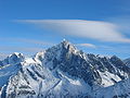
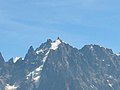
The Aiguille du Dru (also the Dru or the Drus; French, Les Drus) is a mountain in the Mont Blanc massif in the French Alps. It is situated to the east...
11 KB (1,265 words) - 15:20, 25 August 2023

Aiguille du Goûter (3,863 m) is a mountain in the Mont Blanc massif of Haute-Savoie, France. Wikimedia Commons has media related to Aiguille du Goûter...
952 bytes (29 words) - 05:56, 16 October 2021

form of a previously unseen lake emerged at the foot of the Dent du Géant, the Aiguilles Marbrées and the Col de Rochefort at an altitude of about 3400...
6 KB (622 words) - 12:59, 21 October 2022

The Aiguille du Tour (3,540 metres (11,614 ft)) is a mountain in the Mont Blanc massif, located on the border between Switzerland and France. The voie...
2 KB (110 words) - 02:02, 19 October 2021
successful. An attempt on the American Route on South Face of the Aiguille du Fou [fr] failed when a small piton being used for aid pulled near the summit...
9 KB (1,312 words) - 23:47, 3 August 2024
The Grand Couloir is a couloir on the Aiguille du Goûter. At 3,340 metres (10,960 ft) altitude this gully has to be traversed on foot, to reach the scramble...
7 KB (731 words) - 18:28, 8 January 2023

Mont Blanc du Tacul (4,248 m) is a mountain in the Mont Blanc massif of the French Alps situated midway between the Aiguille du Midi and Mont Blanc. The...
3 KB (151 words) - 05:34, 15 October 2021

eight-thousanders Gary Hemming (1934–1969) US, first ascent south face Aiguille du Fou Siegfried Herford (1891–1916) UK, first ascent Scafell Central Buttress...
73 KB (8,702 words) - 06:22, 10 August 2024

Mont Blanc Tunnel (redirect from Tunnel du Mont-Blanc)
highway tunnel. The tunnel passes almost exactly under the summit of the Aiguille du Midi. At this spot, it lies 2,480 metres (8,140 ft) beneath the surface...
15 KB (1,433 words) - 21:45, 5 August 2024
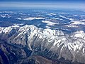
Mont Blanc massif (redirect from Massif du Mont-Blanc)
of slightly lower peaks, including the Aiguille d'Argentière, the Aiguille du Chardonnet and the Aiguille du Tour, before dropping down to the Col de...
150 KB (13,693 words) - 12:51, 27 May 2024

mountain in Western Europe. Between the peaks of the Aiguilles Rouges and the notable Aiguille du Midi, it borders both Switzerland and Italy. It is one...
24 KB (2,154 words) - 15:56, 3 August 2024
south face of the Aiguille du Fou and the American Direct on the Aiguille du Dru, flying to the Dru from the summit of the Aiguille de Blaitière by hang...
17 KB (2,048 words) - 03:31, 28 July 2024

The Aiguille du Chardonnet (3,824 m) is a mountain in the Mont Blanc massif in Haute-Savoie, France. It lies between the Glacier du Tour [fr] and the...
3 KB (297 words) - 15:23, 6 November 2023

The Aiguille du Grépon (literally the Needle of Grépon), informally known as The Grepon, is a mountain in the Mont Blanc Massif in Haute-Savoie, France...
5 KB (646 words) - 16:03, 6 May 2023

Pointe Kurz (redirect from Aiguilles Rouges du Dolent)
Argentière and L'A Neuve, west of La Fouly, the closest locality. The Pointe Kurz is the highest summit of the Aiguilles Rouges du Dolent, a small range situated...
2 KB (146 words) - 09:59, 23 June 2024

The Tour du Mont Blanc or TMB is one of the most popular long-distance walks in Europe. It circles the Mont Blanc massif, covering a distance of roughly...
7 KB (617 words) - 13:40, 8 July 2024

Nid d'Aigle station (redirect from Gare du Nid d'Aigle)
Gare du Nid d'Aigle (French: Eagle's Nest Station) is the terminus of the Tramway du Mont Blanc (TMB) from Saint-Gervais-les-Bains on the slopes of the...
1 KB (187 words) - 01:14, 14 July 2023

north-west slopes of the Aiguille de Bionnassay as well as from the western side of the Dôme du Goûter and the Aiguille du Goûter. It descends for approximately...
10 KB (1,203 words) - 19:43, 30 December 2023
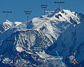
to Aiguille Verte. The Aiguille Verte from Montagne de la Flégère The Aiguille Verte (centre) and the Aiguille du Dru (right) from the Aiguilles Rouges...
8 KB (818 words) - 00:09, 13 June 2024

The Montenvers Railway or Chemin de fer du Montenvers is a rack railway line in the Haute-Savoie department of France. The line runs from a connection...
5 KB (368 words) - 18:52, 17 October 2021

British ascent of the South West Pillar (aka Bonatti Pillar) of the Aiguille du Dru in 1958, and the first ascent of the Central Pillar of Freney on...
17 KB (1,668 words) - 14:27, 6 August 2024

The Aiguilles du Diable (literally "Devil's Needles", German: Teufelsspitzen) are a group of five rock needles, all over 4,000 metres high, on the southeast...
2 KB (243 words) - 19:56, 8 May 2021
ascents per year. The first attempt of this route (from the Aiguille du Goûter up to the Col du Dôme, but not further), was completed on 17 September 1784...
10 KB (1,163 words) - 18:33, 24 October 2023

Gonella refuge. The next day, one proceeds through the Col des Aiguilles Grises and the Dôme du Goûter, concluding at L'arête des Bosses (Bosses ridge). The...
62 KB (6,320 words) - 03:44, 19 July 2024

used as a stopping place for the Tour du Mont Blanc, and is a stage of the Ultra-Trail du Mont-Blanc. La Fouly myswitzerland.com 45°56′N 7°05′E / 45...
961 bytes (116 words) - 04:32, 20 October 2021
Mont Blanc tramway (redirect from Tramway du Mont-Blanc)
782 ft). The initial intention was for the line to reach the much higher Aiguille du Goûter. Nevertheless, it remains one of the highest railways in Europe...
8 KB (714 words) - 02:01, 1 October 2023
Chamonix Aiguilles when viewed from Chamonix. "Topographic map of Aiguille du Plan". opentopomap.org. Retrieved 2023-05-22. The Aiguille du Plan on Summitpost...
2 KB (55 words) - 00:42, 23 May 2023