37°50′16.8″E / 13.1516000°N 37.838000°E / 13.1516000; 37.838000 The Angereb also known as the Bahr as-Salam is a river of Ethiopia and eastern Sudan...
2 KB (192 words) - 08:09, 12 April 2024
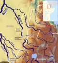
The Lesser Angereb is a river of northern Ethiopia. According to G.W.B. Huntingford, it rises north of the city of Gondar, and flows southeast of that...
1 KB (154 words) - 08:10, 12 April 2024

Agula'i River Genfel Sulluh Ch'eqofo River Balagas River Angereb River (or Greater Angereb River) Shinfa River Rahad River Dinder River Beles River Dabus...
6 KB (572 words) - 06:20, 29 December 2022

Zone of the Amhara Region, Gondar is north of Lake Tana on the Lesser Angereb River and southwest of the Simien Mountains. As of 2021[update], Gondar...
23 KB (1,909 words) - 13:20, 19 June 2024
reaches the Atbara in times of flood) Tekezé River (or Setit) Angereb River (or Greater Angereb River) Blue Nile Rahad River Dinder River White Nile Adar...
2 KB (167 words) - 16:45, 21 February 2023

include the Shinfa River which rises west of Lake Tana, and the Greater Angereb which has its source north of the city of Gondar. The earliest surviving...
8 KB (704 words) - 06:57, 30 July 2024

39722°E / 12.26944; 37.39722. Its tributaries include the Dmaza, the Lesser Angereb, and the Ahyamezoriya. The Magech is known for two bridges over it, which...
2 KB (193 words) - 08:13, 12 April 2024
Samuel southwest of Gondar, or the church of "Tzemba" located on the Lesser Angereb Wolleka Ba'ata Located three kilometers north of Gondar Wrangeb Giyorgis...
8 KB (198 words) - 09:24, 13 August 2023

Chuahit, Gorgora and Koladiba. Rivers within this woreda include the Lesser Angereb and Derma, which flow south into Lake Tana, and the Atbarah. A survey of...
7 KB (674 words) - 17:21, 14 April 2023
38 127 Angereb 12°36′47″N 37°29′10″E / 12.613°N 37.486°E / 12.613; 37.486 (Angereb Reservoir) drinking water irrigation 1986 Lesser Angereb Nile 0...
24 KB (1,616 words) - 12:52, 10 August 2024
location is about 10 kilometers East from Gondar City center, across the Angereb river and Megech River. Gultush topography is mountainous in a way that...
1 KB (132 words) - 22:15, 22 December 2023