Antelope Hills is a census-designated place in Natrona County, Wyoming, United States. It is part of the Casper, Wyoming Metropolitan Statistical Area...
6 KB (473 words) - 05:45, 7 July 2023
Bennett, Colorado Antelope Hills, Wyoming, Natrona County, Wyoming One of a list of mountain ranges named Antelope Antelope Hill, Arizona Angora, Nebraska...
454 bytes (84 words) - 17:42, 9 February 2023
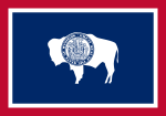
Wyoming (/waɪˈoʊmɪŋ/ wye-OH-ming) is a landlocked state in the Mountain West subregion of the Western United States. It borders Montana to the north and...
115 KB (9,048 words) - 04:08, 11 July 2024

Mark Gordon (redirect from Mark Gordon (Wyoming politician))
sponsors Wyoming Women's Antelope Hunt - Wyoming Women's Antelope Hunt". Retrieved February 16, 2019. Powell, Tori B. (November 25, 2020). "Wyoming Governor...
29 KB (1,668 words) - 15:08, 10 July 2024
The Bridger Antelope Trap is an archaeological site in Uinta County, Wyoming, associated with local Indigenous hunting practices. As an important example...
3 KB (303 words) - 21:29, 5 August 2023

Rolling Hills is a town in Converse County, Wyoming, United States, four miles north of Glenrock. It is a planned community (Zip code: 82637) incorporated...
10 KB (870 words) - 17:31, 30 April 2024

• help) Template:Attached KML/Wyoming Highway 316 KML is from Wikidata Wyoming State Routes 300-399 WYO 316 - I-25 BUS/US 87 BUS to Antelope Gap Road...
4 KB (264 words) - 10:05, 5 January 2023

Edgerton Evansville Midwest Mills Alcova Antelope Hills Bessemer Bend Brookhurst Casper Mountain Hartrandt Homa Hills Meadow Acres Mountain View Powder River...
20 KB (1,735 words) - 15:01, 26 April 2024

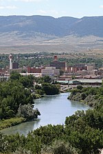
(/dʒɪˈlɛt/, jih-LET) is a city in and the county seat of Campbell County, Wyoming, United States. The town was founded in 1891 as a major railway town on...
53 KB (4,392 words) - 04:07, 28 May 2024

divide near South Pass Wyoming, on the southern end of the Wind River Range. It flows ENE along the north side of the Antelope Hills, then ESE, through Fremont...
8 KB (646 words) - 06:53, 19 February 2022

Battle of Little Robe Creek (redirect from Battle of Antelope Hills)
The Battle of Little Robe Creek, also known as the Battle of Antelope Hills and the Battle of the South Canadian, took place on May 12, 1858. It was a...
35 KB (4,548 words) - 23:36, 30 June 2024

across the Continental Divide, in the Rocky Mountains in southwestern Wyoming. It lies in a broad high region, 35 miles (56 km) wide, between the nearly...
17 KB (1,716 words) - 01:15, 14 September 2023

renewable coming for Wyoming?". Casper Star-Tribune Online. Retrieved January 28, 2020. Wyoming News Exchange (December 11, 2019). "Antelope migration hindered...
23 KB (1,918 words) - 19:27, 13 May 2024

mountain ranges of Utah. Abajo Mountains Antelope Range (Iron County, Utah) Antelope Range (Juab County, Utah) Antelope Range (Sevier County, Utah) Aquarius...
14 KB (1,330 words) - 18:00, 5 December 2023

west) the Ferris Mountains, Green Mountains, Crooks Mountain and the Antelope Hills. There are a few breaks in this range of mountains, i.e., Muddy Gap...
5 KB (553 words) - 19:47, 16 June 2022

The Antelope Island bison herd is a semi–free-ranging population of American bison (Bison bison, buffalo) in Antelope Island State Park in Great Salt...
31 KB (3,718 words) - 20:12, 29 June 2024

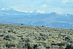
sagebrush steppe located in the south-central portion of the U.S. state of Wyoming, comprising approximately 9,320 square miles (24,100 square kilometers)...
24 KB (2,785 words) - 13:35, 24 October 2023
Casper, Wyoming, Natrona County, Wyoming, the Metropolitan Areas of Wyoming, and the Laramie Mountain Range. Natrona County, Wyoming Wyoming statistical...
7 KB (192 words) - 04:53, 2 June 2024

Sandhills (Nebraska) (redirect from Nebraska Sand Hills)
Nebraska Sand Hills - Virtual Field Trips Dunes were mobile 1,000 years ago Amphibians and Reptiles of the Sand Hills Mammals of the Sand Hills The Nebraska...
24 KB (2,331 words) - 12:38, 18 June 2024
Ghost Towns of Wyoming. Pruett. ISBN 0871085119. "7 Wyoming Ghost Towns You Need to Explore". travelwyoming.com. Hafnor, John. Black Hills Believables:...
8 KB (238 words) - 21:53, 3 June 2024
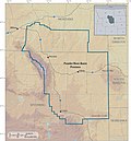
Powder River Basin (category Geology of Wyoming)
Basin is a geologic structural basin in southeast Montana and northeast Wyoming, about 120 miles (190 km) east to west and 200 miles (320 km) north to...
29 KB (3,329 words) - 07:58, 19 October 2023

American bison (redirect from Wyoming state mammal)
Portuguese bufalo (water buffalo), which comes from Latin bufalus (an antelope, gazelle, or wild ox), from Greek boubalos. From the same Greek word boubalos...
98 KB (11,396 words) - 18:44, 10 June 2024

Cheyenne River (category Rivers of Wyoming)
remainder is in Wyoming. Formed by the confluence of Antelope Creek and Dry Fork Creek in Wyoming, it rises in northeastern Wyoming in the Thunder Basin...
10 KB (873 words) - 14:45, 28 March 2024

Pepperdine University Quartz Hill Rose Hills Rowland Heights San Pasqual South Monrovia Island South San Gabriel South San Jose Hills South Whittier Stevenson...
121 KB (7,327 words) - 05:20, 10 July 2024

The Emigrant Trail in Wyoming, which is the path followed by Western pioneers using the Oregon, California, and Mormon Trails (collectively referred to...
25 KB (3,220 words) - 17:36, 22 September 2023
The United States contains a number of mountain ranges named Antelope (or similar): This set index article includes a list of mountains that share the...
5 KB (30 words) - 23:14, 16 September 2022

original on 2009-04-17. Retrieved 2009-04-21. "Wyodak Resources Development Home Page". Wyodak website. Black Hills Corporation. Retrieved 2009-04-21....
10 KB (336 words) - 00:54, 9 May 2023

wildrye, bottlebrush squirreltail, and cheatgrass. Alluvial fans and hills support Wyoming big sagebrush, spiny hopsage, rabbitbrush, Thurber needlegrass,...
26 KB (2,970 words) - 12:15, 8 May 2022
River Indian Reservation, in the west-central portion of the U.S. state of Wyoming, is shared by two Native American tribes, the Eastern Shoshone (Shoshoni:...
62 KB (7,079 words) - 08:38, 22 May 2024

Tongue River (Montana) (redirect from Tongue River (Wyoming))
states of Wyoming and Montana. The Tongue rises in Wyoming in the Big Horn Mountains, flows generally northeast through northern Wyoming and southeastern...
68 KB (9,073 words) - 07:53, 22 April 2024