The Aripuanã National Forest (Portuguese: Floresta Nacional do Aripuanã) is a national forest in the state of Amazonas, Brazil. It supports sustainable...
7 KB (677 words) - 13:26, 3 May 2023
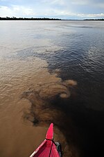
Aripuanã River (Portuguese: Rio Aripuanã) is a river in the Mato Grosso and Amazonas states in north-western Brazil. It is a tributary of the Madeira River...
8 KB (480 words) - 14:35, 12 March 2024
Manicorezinho and Itapinima. The town of Foz do Aripuanã was elevated to the status of a city, named Novo Aripuanã. The first prefect of the municipality, Wilson...
7 KB (588 words) - 20:31, 19 August 2024
990 acres). It adjoins the Aripuanã Sustainable Development Reserve to the west, which lies on either side of the Aripuanã River. To the south, the border...
3 KB (247 words) - 01:57, 4 July 2021

The Arauá River, a tributary of the Aripuanã, also runs north through the reserve. The Aripuanã National Forest is to the south of the reserve. The AM-360/AM-174...
7 KB (839 words) - 19:37, 25 December 2023
Novo Aripuanã (28.68%) in Amazonas. It is north of the BR-230 Trans-Amazonian Highway in the Apuí – Jacareacanga section. The Urupadi National Forest and...
5 KB (417 words) - 07:43, 31 July 2023

Amazon rainforest (redirect from Amazonian forest)
Environment and Sustainable Development in 2009, along the Aripuanã River, in the Aripuanã Sustainable Development Reserve. Also, some community-based...
112 KB (10,712 words) - 12:37, 21 September 2024
Bararati and Aripuanã sustainable development reserves; Guariba Extractive Reserve; and Sucunduri, Aripuanã, Apuí and Manicoré state forests. The management...
4 KB (352 words) - 15:47, 22 September 2024

underparts are whiter than the male's. The Aripuana antwren was first described from the area between the rios Aripuanã and Machado (the interfluvium) in Rondônia...
8 KB (969 words) - 12:15, 14 August 2024

According to the National System of Nature Conservation Units, a national forest of Brazil is an area with forest cover of predominantly native species...
10 KB (78 words) - 20:08, 10 March 2024
993 hectares (375,580 acres), Aripuanã National Forest with 751,295 hectares (1,856,490 acres) and Urupadi National Forest with 537,228 hectares (1,327...
5 KB (456 words) - 22:15, 18 November 2016
993 hectares (375,580 acres), Aripuanã National Forest with 751,295 hectares (1,856,490 acres) and Urupadi National Forest with 537,228 hectares (1,327...
4 KB (405 words) - 13:51, 3 May 2023

municipality contains about 17% of the 751,302 hectares (1,856,510 acres) Aripuanã National Forest, a sustainable development unit created at the same time. The city...
6 KB (411 words) - 20:29, 19 August 2024
the state of Amazonas, Brazil. The Manicoré State Forest is in the Novo Aripuanã municipality of Amazonas. It has an area of 83,381 hectares (206,040 acres)...
4 KB (364 words) - 03:16, 29 June 2022
Manicoré Environmental Protection Area (APA) to the west and by the Aripuanã National Forest to the south and east. Both of these units were created at the...
6 KB (634 words) - 12:02, 23 April 2018
Reserve Aripuanã Sustainable Development Reserve Guariba Extractive Reserve Manicoré State Forest Aripuanã State Forest Sucunduri State Forest Apuí State...
4 KB (372 words) - 21:39, 13 January 2021
Manicoré State Forest. To the north it adjoins the Campos Amazônicos National Park. To the east it adjoins the Aripuanã State Forest. The Guariba River...
5 KB (476 words) - 21:12, 13 January 2021
Sucunduri State Park, Sucunduri State Forest and Aripuanã Sustainable Development Reserve in Amazonas. The Aripuanã River defines the western boundary and...
5 KB (509 words) - 17:15, 22 September 2024

várzea forest in the Monte Alegre Várzea ecoregion along Madeira. There is white sand flooded igapó forest along the clearwater Tapajós and Aripuanã rivers...
12 KB (1,357 words) - 15:06, 28 August 2023
Aripuanã and then to the conservation units via the Aripuanã River. The mosaic contains the Guariba and Sucunduri State Parks; Bararati and Aripuanã sustainable...
5 KB (445 words) - 11:56, 31 May 2022

Roosevelt, sometimes Rio Teodoro) is a Brazilian river, a tributary of the Aripuanã River about 760 km (470 mi) in length. The Roosevelt River begins in the...
13 KB (1,182 words) - 17:43, 23 September 2024
Extractivist Reserve Aripuanã Forest State Park Manicoré Forest State Park Aripuanã Reserva de Desenvolmento Sustentável Campos Amazonicos National Park Rio Flor...
13 KB (1,401 words) - 17:05, 3 December 2023
Bararati and Aripuanã sustainable development reserves; Guariba Extractive Reserve; and Sucunduri, Aripuanã, Apuí and Manicoré state forests. The Southern...
4 KB (398 words) - 03:16, 29 June 2022

2006, extends along the north bank of the river opposite the town of Novo Aripuanã. At its mouth is Ilha Tupinambaranas, an extensive marshy region formed...
23 KB (1,868 words) - 18:42, 18 September 2024
Bararati and Aripuanã sustainable development reserves; Guariba Extractive Reserve; and Sucunduri, Aripuanã, Apuí and Manicoré state forests. The management...
6 KB (554 words) - 12:02, 31 May 2022

Mato Grosso, Brazil. The Campos Amazônicos National Park covers parts of the municipalities of Novo Aripuanã (66.69%), Manicoré (14.73%) and Humaitá (5...
11 KB (1,036 words) - 16:09, 22 September 2024

Forest originated with the 1934 Forest Code. It is equivalent to a national forest, but is administered at the state level. It is an area with forest...
8 KB (439 words) - 15:42, 29 March 2021
or below. The proximity to the forest usually avoids extremes of heat and makes the city wet. According to the National Institute of Meteorology (INMET)...
85 KB (8,138 words) - 09:15, 23 September 2024

had been pre-arranged by Rondon to meet them at the confluence with the Aripuana River, where they had hoped to emerge from the tributary. Medical attention...
13 KB (1,457 words) - 14:39, 16 July 2024

Linhas Aereas), Parintins (Julio Belem), Coari, Lábrea, Manicoré, Novo Aripuanã, Borba, Itacoatiara, Presidente Figueiredo, São Gabriel da Cachoeira, Cucuí...
61 KB (6,476 words) - 12:35, 4 September 2024