Brisbane–Woodford Road is the official name for a continuous 60.5-kilometre (37.6 mi) road route in the Moreton Bay local government area of Queensland...
19 KB (1,038 words) - 16:40, 25 July 2024
entering Strathpine and meeting Brisbane–Woodford Road (Gympie Road) (State Route 58) at a T-junction, where it ends. The road is four lanes for its entire...
28 KB (1,649 words) - 17:25, 5 April 2024
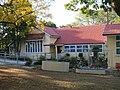
State School is a heritage-listed state school at 42 Dayboro Road (Brisbane Woodford Road), Petrie, City of Moreton Bay, Queensland, Australia. It was...
40 KB (5,410 words) - 01:16, 5 August 2023

Woodford Correctional Centre is an Australian prison facility located on Neurum Road, Woodford, City of Moreton Bay, Queensland, Australia, approximately...
5 KB (475 words) - 21:18, 29 April 2024
D'Aguilar Highway (redirect from Caboolture Connection Road)
roads, from east to west, intersect with the D'Aguilar Highway: Beerburrum Road Caboolture Connection Road Brisbane–Woodford Road Kilcoy–Beerwah Road...
22 KB (1,099 words) - 16:52, 25 July 2024
The road commences in the Brisbane local government area (LGA) but all other intersections are within the Moreton Bay LGA. Clontarf–Anzac Avenue Road is...
13 KB (1,117 words) - 17:59, 25 July 2024

D'Aguilar Highway between Wamuran and Woodford. It is also the northern endpoint of Brisbane–Woodford Road (Mount Mee Road), which leads south through Delaneys...
6 KB (435 words) - 16:52, 25 July 2024

south-east by the South Pine River and Four Mile Creek. Brisbane–Woodford Road, concurrent with Gympie Road enters the suburb from the south (Strathpine) and...
23 KB (1,995 words) - 09:23, 21 September 2024

Ipswich Road is major road in the City of Brisbane, Queensland, Australia. The road has been an important transport route since the 19th century when...
11 KB (856 words) - 12:28, 15 July 2024
Warwick–Killarney Road Details of above roads not described in another article are shown below. Ipswich–Cunningham Highway Connection Road (Brisbane Road / Warwick...
22 KB (1,702 words) - 04:45, 19 October 2024
Connection Road Brisbane Valley Highway Haigslea–Amberley Road Rosewood–Marburg Road Laidley–Plainland Road Forest Hill–Fernvale Road Gatton–Esk Road Gatton–Helidon...
23 KB (1,837 words) - 00:40, 22 January 2024

of Caboolture, Kilcoy, Woodford and Moore. Dalla (also known as Dalambara and Dallambara) is a language of the Upper Brisbane River catchment, notably...
34 KB (3,014 words) - 01:21, 22 September 2024
Connection Road Maroochydore Road Nambour–Bli Bli Road Yandina–Coolum Road Eumundi–Noosa Road Eumundi–Kenilworth Road Cooroy Connection Road Pomona Connection...
40 KB (3,168 words) - 15:45, 4 April 2024
northwest as Brisbane Road (State Route 15) before entering Gympie, turning north at an intersection with Red Hill Road and changing to Crescent Road. At an...
14 KB (1,138 words) - 03:15, 17 August 2024
and in regional Queensland are mostly numbered separately from those of Brisbane. This came into effect in the mid to late 1990s, and some remnants of the...
81 KB (600 words) - 20:26, 24 January 2024
D'Aguilar Highway in Woodford. It runs north-east and north through Stanmore and Cedarton, passing the exit to Commissioners Flat Road to the south-east...
11 KB (820 words) - 17:21, 25 July 2024
state-controlled roads: Gladstone–Benaraby Road Boyne Island Road Gladstone Port Access Road Gladstone–Mount Larcom Road Boyne Island Road is a state-controlled...
3 KB (257 words) - 00:03, 5 March 2024

Bruce Highway (category WikiProject Australian Roads articles with a junction list using templates)
major highway in Queensland, Australia. Commencing in the state capital, Brisbane, it passes through areas close to the eastern coast on its way to Cairns...
103 KB (5,367 words) - 07:03, 20 October 2024

Marlborough–Sarina Road is a state-controlled district road (number 512) rated as a local road of regional significance (LRRS). It runs from the Bruce...
20 KB (1,472 words) - 13:06, 6 October 2024

Burnett Highway (redirect from Murgon–Barambah Road)
Kilkivan–Tansey Road Murgon–Gayndah Road Gayndah–Mount Perry Road Mundubbera–Durong Road Eidsvold–Theodore Road Wuruma Dam Road Monto–Mount Perry Road Gladstone–Monto...
15 KB (910 words) - 06:03, 27 April 2024
Birkdale Road: Brisbane–Redland Road Intersecting with Brisbane–Redland Road and Birkdale Road: Capalaba–Victoria Point Road Birkdale Road is a state-controlled...
15 KB (1,201 words) - 16:48, 25 July 2024
22A: Kingaroy–Cooyar Road Oakey–Cooyar Road Pechey–Maclagan Road Esk–Hampton Road Murphys Creek Road Toowoomba Connection Road (former Warrego Highway)...
12 KB (1,002 words) - 01:05, 22 January 2024

state-controlled roads, from south to north, intersect with the Brisbane Valley Highway: Forest Hill–Fernvale Road Wivenhoe–Somerset Road Coominya Connection Road Gatton–Esk...
13 KB (759 words) - 12:20, 15 July 2024
state-controlled roads intersect with section 25A: Camp Cable Road Beaudesert–Boonah Road Camp Cable Road is a state-controlled district road (number 2071)...
6 KB (496 words) - 02:20, 5 March 2024

Flinders Highway, Queensland (redirect from Julia Creek–Kynuna Road)
Road Burdekin Falls Dam Road Aramac–Torrens Creek Road Hughenden–Muttaburra Road Richmond–Winton Road Julia Creek–Kynuna Road Julia Creek–Kynuna Road...
19 KB (1,267 words) - 00:30, 5 May 2024

Birdsville Track (category WikiProject Australian Roads articles with a junction list using templates)
stock route was at least 1,000 km shorter than the alternative path to Brisbane. By 1916 enough bores had been sunk into the Great Artesian Basin along...
10 KB (856 words) - 12:52, 22 June 2024
Roma–Condamine Road is a continuous 115-kilometre (71 mi) road route in the Maranoa and Western Downs local government areas of Queensland, Australia...
12 KB (1,032 words) - 03:48, 17 August 2024
Roma–Taroom Road is a continuous 149-kilometre (93 mi) road route in the Maranoa, Western Downs and Banana local government areas of Queensland, Australia...
10 KB (780 words) - 03:35, 17 August 2024
Cooroy–Noosa Road is a continuous 12.5-kilometre (7.8 mi) road-route in the Noosa local government area of Queensland, Australia. It is signed as 'State...
10 KB (751 words) - 13:50, 12 August 2024
Bundaberg–Bargara Road is a state-controlled district road (number 174) in the Bundaberg region of Queensland, Australia. It is rated as a local road of regional...
11 KB (758 words) - 16:40, 25 July 2024