
Kanata to Bronson Avenue in the Glebe. The road is named for John Carling, founder of Carling Brewery and Conservative MP and Senator, Postmaster General and...
6 KB (664 words) - 18:37, 25 January 2024

Dow's Lake station (redirect from Carling O-Train Station)
Lake (formerly known as Carling) is an O-Train station on the Trillium Line, one block west of the intersection of Carling Avenue and Preston Street in...
3 KB (178 words) - 00:57, 29 July 2024
National Defence Headquarters Carling, or NDHQ Carling (originally Carling Campus), is a 148.79-hectare (367.7-acre) site containing federal government...
12 KB (973 words) - 17:09, 19 March 2024

Street South, Carling Avenue and Dow's Lake. This area includes the Glebe Annex, an area west of Bronson Avenue, north of Carling Avenue, east of LeBreton...
18 KB (2,030 words) - 03:27, 18 July 2024

the Ottawa River in Ottawa, Ontario, Canada. It runs from Carling Avenue near Connaught Avenue, to Booth Street at the Canadian War Museum and National...
16 KB (1,705 words) - 17:17, 21 July 2024
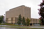
The Sir John Carling Building was located along Carling Avenue at the Central Experimental Farm, in Ottawa, Ontario, Canada. Until 2010, it was the headquarters...
5 KB (403 words) - 21:01, 4 May 2024

Little Italy, Ottawa (redirect from Preston Avenue)
Albert Street to the north, Carling Avenue to the south, the O-Train Trillium Line to the west, and approximately Bronson Avenue to the east, while the neighbourhood's...
5 KB (433 words) - 18:45, 11 February 2024

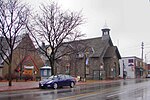
to Carling Avenue contains a mix of homes and a number of public institutions. This includes Our Lady Of Fatima Catholic Church, Woodroffe Avenue United...
5 KB (729 words) - 22:15, 23 June 2023

Ottawa Hospital. The Civic Campus opened in 1924 and is located at 1053 Carling Avenue in Ottawa, Ontario, Canada. The hospital was championed largely by Harold...
7 KB (711 words) - 03:03, 14 July 2024
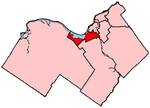
wards, the part of Dalhousie Ward north of Carling Avenue, the part of Capital Ward north of Carling Avenue and Linden Terrace, and the parts of Victoria...
22 KB (419 words) - 23:27, 9 January 2024

Lincoln Fields is a station on Ottawa's transitway located at Carling Avenue and the Kichi Zibi Mikan. It is adjacent to the now-shuttered Lincoln Fields...
7 KB (395 words) - 01:42, 29 July 2024
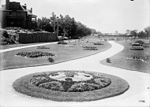
park was completed in 1907. In the 1960s, the city proposed extending Carling Avenue through the park to the canal. This caused an outcry in the community...
1 KB (167 words) - 17:26, 30 November 2019

have been consolidating at National Defence Headquarters, Carling Campus on Carling Avenue. During the Cold War, the threat of nuclear attack on the National...
4 KB (494 words) - 09:39, 13 February 2024

triangular in shape, and its boundaries can broadly be described as Carling Avenue to the northeast, Moodie Drive to the west, and Corkstown Road to the...
5 KB (666 words) - 12:07, 1 August 2024

Pasture and between Carling Avenue and Highway 417. OC Transpo Route 14 runs along Parkdale Avenue from Carling Avenue to Gladstone Avenue where the route...
2 KB (215 words) - 22:23, 23 June 2023
from Highway 7 and Highway 15 (Richmond Road) to Carling Avenue; phase three, from Carling Avenue to O'Connor Street; and, phase four, from O'Connor...
63 KB (5,146 words) - 13:26, 6 August 2024
also been shifted east, from Maitland and Sherwood Avenues to Golden Avenue and then along Carling Avenue to the 417 Highway. Consequently the McKellar Park...
19 KB (805 words) - 17:16, 7 July 2024

Ottawa west of Parkdale Avenue, the part of Dalhousie ward south of Carling Avenue, the part of Capital ward south of Carling Avenue and Linden Terrace, and...
28 KB (1,333 words) - 10:33, 28 July 2024

the south end of Preston Street, just south of Carling Avenue, and just to the west of Bronson Avenue. At the south end of the lake is Carleton University...
6 KB (647 words) - 22:37, 10 May 2024

John Carling, PC KCMG (January 23, 1828 – November 6, 1911) was a Canadian politician and prominent businessman who was associated with the Carling Brewery...
9 KB (738 words) - 23:11, 1 May 2024

bounded on the west by Woodroffe Avenue north by Carling Avenue, south by The Queensway and on the east by Maitland Avenue. The population at the 2011 census...
5 KB (324 words) - 04:51, 26 January 2023
Carling, Carlings, carling, or carlings in Wiktionary, the free dictionary. Carling is a Canadian brewery. Carling may also refer to: Carling Avenue,...
1 KB (171 words) - 06:07, 8 July 2024
are the Transitway to the north, Tweedsmuir Avenue to the east, Carling Avenue to the south and Denbury Avenue to the west. This area excludes the neighbourhood...
11 KB (965 words) - 10:29, 24 February 2024
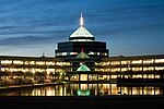
tower in Ottawa, Ontario, Canada. It is located at the intersection of Carling Avenue and Preston Street in Little Italy. When the structure topped out in...
6 KB (365 words) - 18:39, 10 January 2024

Heights neighbourhood of Ottawa, Ontario, Canada. It was located between Carling Avenue and Richmond Road just west of Lincoln Fields station. In October 2019...
6 KB (448 words) - 13:39, 14 December 2023

Baseline Road to the south, and Merivale and Fisher Roads to the west, and Carling Avenue to the north. The Victorian era was a time of great interest in the...
16 KB (1,624 words) - 15:03, 30 July 2024
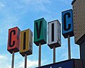
line Carling Avenue along the area's southern edge. The 1960 Googie-inspired Civic Pharmacy Building sign at the corner of Carling and Holland Avenues is...
8 KB (575 words) - 17:25, 18 January 2024
in Ottawa, Ontario, Canada. It is located between Carling Avenue and Richmond Road, Churchill Avenue and Denbury Ave. It is a mixed-income neighbourhood...
2 KB (247 words) - 22:24, 9 January 2024
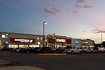
The Fairlawn Centre (formerly Fairlawn Plaza) is a strip mall along Carling Avenue in Ottawa, Ontario, Canada. The mall opened in 1961 when the plaza's...
2 KB (217 words) - 10:25, 23 August 2022
east–west LRT Confederation Line. Long-term plans had included lines on Carling Avenue from the existing Dow's Lake station westward to Bayshore and Bells...
43 KB (4,370 words) - 10:15, 17 July 2024