
Cheung Sha Wan Road (Chinese: 長沙灣道; Jyutping: coeng4 saa1 waan4 dou6) is a main thoroughfare in Kowloon, Hong Kong going in a south-north direction from...
5 KB (433 words) - 15:53, 15 July 2024

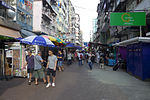
Cheung Sha Wan (長沙灣; Chèuhngsāwàahn; 'Long Sandy Bay') is an area between Lai Chi Kok and Sham Shui Po in New Kowloon, Hong Kong. It is mainly residential...
13 KB (1,344 words) - 12:46, 23 June 2024

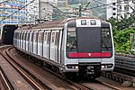
Cheung Sha Wan (Chinese: 長沙灣) is an underground station located underneath Cheung Sha Wan Road in Sham Shui Po District on the Tsuen Wan line of Hong Kong...
5 KB (174 words) - 17:45, 10 July 2024

The following is an overview of Public housing estates in Cheung Sha Wan, Hong Kong, including Home Ownership Scheme (HOS), Green Form Subsidised Home...
18 KB (1,309 words) - 11:49, 16 February 2024
Cheung Sha Wan Estate (Chinese: 長沙灣邨) is a public housing estate in Cheung Sha Wan, Kowloon, Hong Kong, built on the site of the former Cheung Sha Wan...
6 KB (439 words) - 12:57, 17 August 2021

Cheung Sha Wan Plaza (Chinese: 長沙灣廣場; Cantonese Yale: chēuhng sā wāhn gwóng chēuhng, Jyutping: coeng4 saa1 waan1 gwong2 coeng4) is shopping centre and...
2 KB (114 words) - 01:23, 19 March 2024
Bay), Lai Wan (now Mei Foo) was Lai Chi Kok, Lai Chi Kok was Cheung Sha Wan, Cheung Sha Wan was So Uk. These stations were all renamed in English and Chinese...
25 KB (2,237 words) - 04:24, 26 April 2024

Lai Chi Kok station (category Cheung Sha Wan)
茘枝角) is a rapid transit station on the Tsuen Wan line of the Hong Kong MTR system, between Cheung Sha Wan and Mei Foo stations. It was opened on 17 May...
7 KB (363 words) - 17:41, 10 July 2024

based on the area of Cheung Sha Wan and Sham Shui Po bounded by Pratas Street, Cheung Sha Wan Road, Yen Chow Street and Tai Po Road. "Recommended District...
13 KB (144 words) - 01:59, 11 April 2023

Shek Wan (to the northeast). The most notable feature of the area is the Cheung Sha Beach, the longest beach in Hong Kong. The South Lantau Road, passing...
4 KB (411 words) - 18:31, 2 July 2022

northwestern part of the Kowloon Peninsula, north of Tai Kok Tsui, east of Cheung Sha Wan and south of Shek Kip Mei (石硤尾). It is located in and is the namesake...
16 KB (1,822 words) - 12:46, 23 June 2024

Sham Shui Po station (category Tsuen Wan line)
Kong. The station is located under Cheung Sha Wan Road between Cheung Sha Wan and Prince Edward stations on the Tsuen Wan line. Sham Shui Po's colour is dark...
5 KB (153 words) - 14:13, 16 July 2024

Un Chau Estate (category Cheung Sha Wan)
reclaimed land of Cheung Sha Wan, Kowloon, Hong Kong, located between Un Chau Street [zh] and Cheung Sha Wan Road, next to MTR Cheung Sha Wan station. It consists...
6 KB (478 words) - 21:31, 17 July 2024
Road Baptist University Road Beacon Hill Road Boundary Street Broadcast Drive Broadway Castle Peak Road Chester Road Cheung Sha Wan Road Ching Cheung...
29 KB (3,313 words) - 14:56, 5 June 2024

Tonkin Street (category Cheung Sha Wan)
Shui Po and Cheung Sha Wan of New Kowloon in Hong Kong. It runs northeast to southwest and crosses many major roads in the Cheung Sha Wan area. After...
5 KB (547 words) - 22:11, 12 July 2024

Bay – 6 beach road, Repulse Bay Sai Kung – 66 Man Nin Street Sha Tin – 14-16 Man Lai Road, Tai Wai Sham Shui Po – 330 Cheung Sha Wan Road Sham Tseng –...
14 KB (1,796 words) - 01:03, 28 June 2024
Apliu Street (category Roads in New Kowloon)
Shui Po area of Kowloon, Hong Kong. Apliu Street runs parallel to Cheung Sha Wan Road between Yen Chow Street and Nam Cheong Street. An easy way to reach...
4 KB (312 words) - 03:59, 23 May 2024

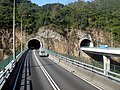
tunnels were officially opened on 21 March 2008. The tunnels connect Cheung Sha Wan through Eagle's Nest hill to Tai Wai, and are linked by a shared toll...
7 KB (573 words) - 02:53, 15 October 2022
Sham Shui Po District administers: Cheung Sha Wan – Between Tonkin Street and Kom Tsun Street / Butterfly Valley Road. Western Part of Kowloon Tong – West...
11 KB (891 words) - 08:44, 6 July 2024

road starts off in Sha Tin at an intersection with Tai Po Road – Sha Tin, then heads southwest towards Cheung Sha Wan through the Tai Wai Tunnel, Sha...
12 KB (673 words) - 01:01, 18 December 2023
Beaches of Hong Kong (section Cheung Sha Beaches)
Chung Wan (涌灣) South Crooked Harbour, North District Cheung Sha Wan (長沙灣) Northeast Ping Chau Crescent Bay (娥眉灣) Crescent Island, Mirs Bay Lo Kei Wan (籮箕灣)...
22 KB (2,924 words) - 20:00, 19 April 2024
Ching Cheung along a four-lane expressway to Kwai Chung and downhill into Tsuen Wan. The stretch within Tsuen Wan is also commonly called "main road" (大馬路)...
8 KB (607 words) - 02:53, 5 May 2024

Hoi Lai Estate (category Cheung Sha Wan)
is a public housing estate in Cheung Sha Wan, Kowloon, Hong Kong, built on the reclaimed land of south Cheung Sha Wan, near Lai Chi Kok station and four...
6 KB (336 words) - 13:06, 13 March 2023

maa4 waan1 bun3 dou2) is where Chi Ma Wan, as well as Cheung Sha Wan, Tai Long Wan, Yi Long Wan and Mong Tung Wan are located. The Peninsula is located...
5 KB (581 words) - 09:25, 9 March 2024

ending northward at Austin Road. When Sha Tsui Wan was reclaimed in the late 1800s, Salisbury Road was extended east, and Nathan Road was extended south to...
10 KB (973 words) - 18:16, 13 May 2024

Route 8 (Hong Kong) (category Infobox road maps for Wikidata migration)
carriageway motorway that links Lantau Island, Tsing Yi Island, Cheung Sha Wan in West Kowloon, and Sha Tin in the southeast New Territories of Hong Kong. It is...
11 KB (640 words) - 10:14, 5 October 2023
Shing Mun Tunnels (category Sha Tin District)
Tsuen Wan end of the tunnel. The tunnels lead to Cheung Pei Shan Road and connect Wo Yi Hop Interchange in Tsuen Wan, and Shing Mun Tunnel Road in the...
5 KB (325 words) - 10:24, 9 June 2024

neighbourhood in Kowloon, Hong Kong, east of Kwai Chung and west of Cheung Sha Wan. Mei Foo Sun Chuen is the largest housing estate in the area and also...
8 KB (614 words) - 12:46, 23 June 2024
Estate Cheung Pei Shan Road Cheung Po Tsai Cheung Sha Wan Cheung Sha Wan Road Cheung Shue Tau Cheung Tsing Bridge Cheung Tsing Highway Cheung Tsing Tunnel...
62 KB (6,716 words) - 18:46, 12 July 2024

Lai Tsui Court (category Cheung Sha Wan)
Lai Chi Kok Road and Tonkin Street in Cheung Sha Wan of Sham Shui Po District. It was formerly the site of the demolished Cheung Sha Wan Estate and just...
3 KB (230 words) - 00:32, 3 July 2023