
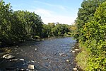
The Chicopee River is an 18.0-mile-long (29.0 km) tributary of the Connecticut River in the Pioneer Valley, Massachusetts, known for fast-moving water...
8 KB (821 words) - 13:28, 24 May 2023

Chicopee (/ˈtʃɪkəpi/ CHIK-ə-pee) is a city located on the Connecticut River in Hampden County, Massachusetts, United States. At the 2020 census, the city...
60 KB (6,660 words) - 02:06, 23 April 2024
Massachusetts Chicopee River, Massachusetts Chicopee Valley Aqueduct Chicopee Falls Dam Chicopee, Missouri USS Chicopee (1863), a Civil War era vessel Chicopee class...
649 bytes (99 words) - 01:17, 7 September 2018

Connecticut River at two of its major tributaries—the Chicopee River to the east and Westfield River to the west—and just north of Enfield Falls, the river's first...
75 KB (7,144 words) - 17:13, 15 August 2024
Red Bridge Hydro (redirect from Chicopee River Reservoir)
(shortened to "Red Bridge") is a hydroelectric power plant located on the Chicopee River in the towns of Wilbraham, Ludlow, Palmer, and Belchertown, Massachusetts...
5 KB (561 words) - 00:11, 2 May 2024

poplar trees located along the Chicopee River made excellent canoes, and two have been found carved out along the Chicopee River over the years. The Nipmuc...
24 KB (2,810 words) - 14:31, 30 June 2024

named for the confluence of the Ware and Quaboag rivers, which form the Chicopee River. Three Rivers is located at 42°10′45″N 72°21′50″W / 42.17917°N...
7 KB (545 words) - 05:16, 21 June 2024

Ludlow, Massachusetts (category Massachusetts populated places on the Connecticut River)
Statistical Area. Located just northeast of Springfield across the Chicopee River, it is one of the city's suburbs. It has a sizable and visible Portuguese...
19 KB (2,155 words) - 13:27, 17 August 2024

The Chicopee Falls Dam is a masonry stone dam that parallels Route 33 (Bridge Street) in Chicopee, Massachusetts. It is part of the Chicopee River Watershed...
2 KB (175 words) - 02:54, 3 September 2023

Quaboag. The Quaboag flows northwest to the Chicopee River, a west-flowing tributary of the Connecticut River. The northwestern portion of Monson drains...
17 KB (1,983 words) - 14:50, 2 May 2024

of Chicopee. The City of Chicopee features the confluence of the fast-moving Chicopee River and the meandering Connecticut River. The Chicopee River, although...
70 KB (8,695 words) - 22:43, 6 April 2024

She was the second U.S. Navy ship named for the Chicopee River located in Massachusetts. Chicopee was laid down as Esso Trenton on 14 May 1941 under...
8 KB (648 words) - 20:08, 19 October 2023

Springfield, Massachusetts (category Massachusetts populated places on the Connecticut River)
Connecticut River near its confluence with three rivers: the western Westfield River, the eastern Chicopee River, and the eastern Mill River. At the 2020...
192 KB (17,525 words) - 12:53, 20 August 2024
Bumps River Bungay River Burnshirt River Canoe River Castle Neck River Cedar Swamp River Centerville River Charles River Chickley River Chicopee River Childs...
20 KB (1,631 words) - 16:33, 4 August 2024

the largest dams in the Eastern U.S. The Winsor Dam is part of the Chicopee River Watershed. The Winsor Dam was named for Frank E. Winsor, its chief engineer...
2 KB (151 words) - 22:38, 6 December 2023

Springfield, across the Chicopee River from Ludlow. At the end of this route, the road now known as Old Boston Road, Stony Hill Road and River Road was used. The...
5 KB (647 words) - 19:10, 19 October 2021
in Chicopee to the center of Holyoke, a distance of about 4.46 miles (7.18 km). It runs near the Connecticut River throughout its journey in Chicopee, crosses...
10 KB (749 words) - 01:20, 3 July 2024

Massachusetts. Located in the northeast corner of Springfield, next to the Chicopee River, Indian Orchard is the city's fifth largest neighborhood. Indian Orchard...
6 KB (534 words) - 02:15, 10 August 2023

arrival of jute mills on the Chicopee River. The district is roughly bounded by Winsor, Sewall and State Sts. and the Chicopee River. It was listed on the National...
4 KB (365 words) - 17:35, 22 June 2024
Commonwealth. The Westfield River is the Connecticut River's longest tributary in Massachusetts, although the Chicopee River's basin is much larger, and...
13 KB (1,105 words) - 19:21, 29 July 2024

The Ware River flows through the center of the village, running southwest to join the Quaboag River in Palmer, forming the Chicopee River. Massachusetts...
8 KB (659 words) - 06:02, 14 July 2023

of the Chicopee River Watershed. Constructed in 1890, it has withstood the floods that have taken out most of the other dams on the Quaboag River. In 2005...
2 KB (235 words) - 14:24, 9 July 2021

Ware River flows southwest through the middle of the state, joins the Quaboag River at Three Rivers, Massachusetts, to form the Chicopee River on its...
8 KB (902 words) - 22:38, 27 February 2023

meeting in Palmer to form the Chicopee River (along with the Quaboag River), which flows into the Connecticut River. The lands of Ware are hilly between...
19 KB (2,067 words) - 12:10, 19 August 2024

joining the Ware River and Swift River in Three Rivers, to form the Chicopee River. This river is therefore part of the Chicopee River Watershed. Numerous...
5 KB (501 words) - 22:09, 28 June 2022

water to Wilbraham, South Hadley fire district #1, and Chicopee. It is part of the Chicopee River Watershed. In 1947, the Massachusetts Legislature authorized...
2 KB (152 words) - 15:12, 11 January 2021

Falls reservoir is located within the Upper Ware River Watershed and is part of the Chicopee River Watershed. Access to the site is available from Route...
4 KB (407 words) - 17:29, 21 February 2023

Interstate 291 (Massachusetts) (category Chicopee, Massachusetts)
links I-91 in downtown Springfield with I-90 (Massachusetts Turnpike) in Chicopee. I-291 is roughly a northeast–southwest highway. It merges with I-91 at...
11 KB (864 words) - 01:05, 6 July 2024

The Conant Brook Dam is located within the Chicopee River watershed and is part of the Connecticut River basin. Access to the site is available from...
4 KB (466 words) - 21:11, 1 November 2023

widespread flooding. Flash flooding on the Chicopee River washed away the Chicopee Falls Bridge, while the Connecticut River flooded most of the Willimansett section...
58 KB (6,297 words) - 19:37, 17 August 2024