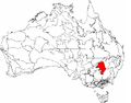
Cobar Peneplain, an interim Australian bioregion, is located in New South Wales, and comprises 7,385,346 hectares (18,249,590 acres). The bioregion has...
4 KB (152 words) - 09:08, 24 March 2024

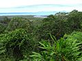
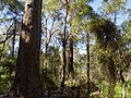
Pulletop Nature Reserve is a protected nature reserve, located in the Cobar Peneplain region of New South Wales, in eastern Australia. The 145 ha (360-acre)...
8 KB (624 words) - 17:00, 9 July 2024
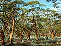
Myall Woodland in the Darling Riverine Plains, Brigalow Belt South, Cobar Peneplain, Murray-Darling Depression, Riverina and NSW South Western Slopes bioregions...
8 KB (439 words) - 11:53, 27 September 2023
Wales. Sydney: Govt. Printer. Office of Environment and Heritage. "Cobar Peneplain - regional history". www.environment.nsw.gov.au. Retrieved 24 September...
27 KB (3,108 words) - 00:37, 6 October 2024
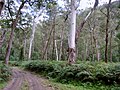
Box Woodland in the Darling Riverine Plains, Brigalow Belt South, Cobar Peneplain and Mulga Lands Bioregions EEC 5 October 2012 Dry Rainforest of the...
28 KB (268 words) - 21:38, 12 October 2024

Central Kimberley Central Mackay Coast Central Ranges Channel Country Cobar Peneplain Coolgardie Coral Sea Cumberland Plain Daly Basin Dampierland Darling...
23 KB (2,112 words) - 21:18, 13 July 2024

ecoregion as defined by WWF includes the Darling Riverine Plains, Cobar Peneplain, and Riverina IBRA regions, along with the southern portion of the...
9 KB (907 words) - 04:33, 19 September 2024

Nymagee (category Cobar Shire)
has also been designated as an IBRA biogeographic subregion of the Cobar Peneplain biogeographic region. Nymagee was originally a copper mining town and...
5 KB (464 words) - 21:59, 9 October 2024
Belt South (part) Broken Hill Complex (part) Channel Country (part) Cobar Peneplain Darling Riverine Plains (part) Flinders Lofty Block (part) Mulga Lands...
27 KB (1,851 words) - 19:39, 5 June 2024

Central Kimberley Central Mackay Coast Central Ranges Channel Country Cobar Peneplain Coolgardie Coral Sea Cumberland Plain Daly Basin Dampierland Darling...
24 KB (2,464 words) - 11:13, 30 August 2024

Queensland tropical rain forests Coolgardie (COO) Coolgardie woodlands Cobar Peneplain (COP) Southeast Australia temperate savanna Coral Sea (COS) Cape York...
13 KB (734 words) - 11:35, 12 August 2024
Central Kimberley Central Mackay Coast Central Ranges Channel Country Cobar Peneplain Coolgardie Coral Sea Cumberland Plain Daly Basin Dampierland Darling...
12 KB (1,137 words) - 23:22, 5 September 2024

Mount Hope, New South Wales (category Cobar Shire)
country on the boundaries between three major biophysical regions: the Cobar Peneplain, the Darling Depression and the Southern Riverine Plain. The area protects...
27 KB (3,419 words) - 11:56, 21 October 2024

Central Kimberley Central Mackay Coast Central Ranges Channel Country Cobar Peneplain Coolgardie Coral Sea Cumberland Plain Daly Basin Dampierland Darling...
13 KB (1,396 words) - 23:06, 16 October 2024

Central Kimberley Central Mackay Coast Central Ranges Channel Country Cobar Peneplain Coolgardie Coral Sea Cumberland Plain Daly Basin Dampierland Darling...
9 KB (903 words) - 23:14, 12 April 2024

Western Slopes: Darling Riverine Plains Brigalow Belt South Sydney Basin Cobar Peneplain South Western Slopes South Eastern Highlands Riverina South Eastern...
15 KB (1,317 words) - 09:19, 16 September 2024

Central Kimberley Central Mackay Coast Central Ranges Channel Country Cobar Peneplain Coolgardie Coral Sea Cumberland Plain Daly Basin Dampierland Darling...
5 KB (425 words) - 14:55, 22 May 2024

occurs in New South Wales in the Riverina, Darling Riverine Plains, Cobar Peneplain and New England Tablelands bioregions. The type locality is Girilambone...
2 KB (105 words) - 13:01, 1 September 2023
Central Kimberley Central Mackay Coast Central Ranges Channel Country Cobar Peneplain Coolgardie Coral Sea Cumberland Plain Daly Basin Dampierland Darling...
33 KB (3,915 words) - 12:41, 11 September 2024

acres) Central Depression CHC13 580,685 hectares (1,434,900 acres) Cobar Peneplain COP 7,385,346 hectares (18,249,590 acres) NSW Boorindal Plains COP1...
83 KB (346 words) - 21:59, 23 April 2024
the aborigines of New South Wales". Science of Man. 6 (3): 46–48. "Cobar Peneplain - regional history Aboriginal occupation". Office of Environment &...
12 KB (1,089 words) - 18:49, 20 September 2024

Central Kimberley Central Mackay Coast Central Ranges Channel Country Cobar Peneplain Coolgardie Coral Sea Cumberland Plain Daly Basin Dampierland Darling...
20 KB (2,257 words) - 04:11, 13 July 2024

Central Kimberley Central Mackay Coast Central Ranges Channel Country Cobar Peneplain Coolgardie Coral Sea Cumberland Plain Daly Basin Dampierland Darling...
17 KB (1,808 words) - 02:58, 10 August 2024
Central Kimberley Central Mackay Coast Central Ranges Channel Country Cobar Peneplain Coolgardie Coral Sea Cumberland Plain Daly Basin Dampierland Darling...
7 KB (651 words) - 03:02, 14 August 2023

Central Kimberley Central Mackay Coast Central Ranges Channel Country Cobar Peneplain Coolgardie Coral Sea Cumberland Plain Daly Basin Dampierland Darling...
4 KB (440 words) - 12:44, 6 June 2024

Regionalisation of Australia Region, in some of the sub-regions of the Cobar Peneplain Interim Biogeographic Regionalisation of Australia Region, and in sub-regions...
9 KB (819 words) - 16:15, 8 April 2023
Central Kimberley Central Mackay Coast Central Ranges Channel Country Cobar Peneplain Coolgardie Coral Sea Cumberland Plain Daly Basin Dampierland Darling...
41 KB (4,733 words) - 02:47, 18 October 2024

Rankins Springs is within the Lachlan Plains subregion of the extensive Cobar Peneplain Bioregion (comprising 9.2 percent of New South Wales). Rankins Springs...
24 KB (2,995 words) - 13:20, 9 July 2024

Central Kimberley Central Mackay Coast Central Ranges Channel Country Cobar Peneplain Coolgardie Coral Sea Cumberland Plain Daly Basin Dampierland Darling...
6 KB (450 words) - 04:43, 23 May 2024

Central Kimberley Central Mackay Coast Central Ranges Channel Country Cobar Peneplain Coolgardie Coral Sea Cumberland Plain Daly Basin Dampierland Darling...
5 KB (441 words) - 20:33, 5 September 2024