
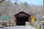
Route 337 is a state highway in southern Connecticut running for 4.91 miles (7.90 km) from US 1 in New Haven to Route 142 in East Haven. The road serves...
4 KB (326 words) - 02:44, 2 March 2023
numbered 337: Nova Scotia Route 337 Prince Edward Island Route 337 Quebec Route 337 Japan National Route 337 Arkansas Highway 337 Connecticut Route 337 Georgia...
2 KB (133 words) - 23:22, 4 April 2024

became Route 337 in 1987. The entire route is in New Haven County. Connecticut State Highway Log Archived 2015-09-05 at the Wayback Machine Connecticut Public...
4 KB (352 words) - 03:49, 26 April 2024
along the Connecticut shoreline, usually with less traffic. The six-lane highway is reduced to four lanes in Branford, interchanges with Route 9 at exit 69...
55 KB (4,675 words) - 00:40, 5 August 2024

U.S. Route 1 (US 1) in the U.S. state of Connecticut is a major east–west U.S. Route along Long Island Sound. It has been replaced by Interstate 95 (I-95)...
22 KB (640 words) - 01:02, 5 June 2024

New England road marking system (redirect from Route 116 (Connecticut 1920s))
by Connecticut Route 9, U.S. Route 44, Connecticut Route 189, Connecticut Route 10, Massachusetts Route 10, New Hampshire Route 10, and U.S. Route 302...
158 KB (6,445 words) - 17:10, 1 February 2024

Route 100 is a state highway in Connecticut that connects the town center of East Haven with the Foxon community in the northern part of town. Route 100...
4 KB (333 words) - 08:45, 25 February 2023

Route 122 is a primary, minor arterial highway in the United States. It begins at Interstate 95 in West Haven, Connecticut. It runs north of West Haven...
5 KB (512 words) - 19:19, 31 May 2024
maintained. Interstate highways and U.S. highways in the state are not Connecticut state routes, however they are maintained by the state. All state highways are...
84 KB (1,553 words) - 04:13, 1 January 2024

neighborhood. Here, I-95 has an interchange with the northern terminus of Route 337, which provides access to Tweed New Haven Airport. Past this interchange...
52 KB (4,477 words) - 11:56, 22 July 2024

Route 341 is a state highway in western Connecticut, running from the New York state line in Kent to Washington. Route 341 begins at an intersection with...
4 KB (239 words) - 02:44, 2 March 2023

Route 334 is a Connecticut state highway in the Naugatuck River valley, running from Seymour to Ansonia. Route 334 begins at an intersection with Route...
3 KB (231 words) - 12:50, 24 March 2024

Frederic. The Reluctant Republic, New York: John Day, 1941. p. 337 "Fast Facts". Connecticut River Joint Commissions. Archived from the original on August...
75 KB (7,144 words) - 17:13, 15 August 2024

Mascot is "Eagle". Ranked No. 337 out of 500 top schools in the nation in 2014. Major roads: CT Route 69 and CT Route 322, both roads intersect with...
19 KB (1,780 words) - 21:22, 28 April 2024

(/ˈɡrɛnɪtʃ/ GREH-nitch) is a town in southwestern Fairfield County, Connecticut, United States. At the 2020 census, it had a population of 63,518. Greenwich...
71 KB (4,675 words) - 23:43, 26 July 2024
1817 and 1826. The town is served by Connecticut Route 4, U.S. Route 7, and Connecticut Routes 43, 125 and 128. Route 4 leads east 13 miles (21 km) to Torrington...
24 KB (1,703 words) - 07:58, 19 May 2024

Historic District – Roughly bounded by Strong Road, U.S. Route 5, Interstate 291, and the Connecticut River, added in 1986 According to the United States Census...
23 KB (1,487 words) - 22:11, 5 August 2024

Lyme is a town in New London County, Connecticut, United States. The town is part of the Southeastern Connecticut Planning Region. The population was 18...
41 KB (3,800 words) - 02:28, 5 July 2024

Connecticut, United States. It borders the city of Bridgeport and towns of Trumbull, Easton, Weston, and Westport along the Gold Coast of Connecticut...
63 KB (4,971 words) - 15:20, 10 August 2024

Pan-American Highway (redirect from Pan-American Highway (route))
Pan-American Highway in Tres Rios, Costa Rica, right before the toll plaza (about 337 more km / 209 more mi to go until the Panamanian border). Pan-American Highway...
71 KB (8,735 words) - 15:22, 14 August 2024
census-designated place (CDP) within the town of North Canaan in Litchfield County, Connecticut, United States. Formerly known as Canaan Depot, the village is more commonly...
9 KB (749 words) - 03:17, 11 July 2024
List of highways numbered 9A (redirect from Route 9A)
Route 9A can refer to the following highways: Connecticut Route 9A (former) Delaware Route 9A Florida State Road 9A (Jacksonville) Florida State Road 9A...
1,000 bytes (94 words) - 15:51, 26 June 2024
List of highways numbered 66 (redirect from State Route 66)
Route 66 Arizona State Route 66* Arkansas Highway 66 California State Route 66* County Route 66 (California)* Colorado State Highway 66 Connecticut Route...
7 KB (539 words) - 22:51, 7 August 2024

A reference route is an unsigned highway assigned by the New York State Department of Transportation (NYSDOT) to roads that possess a signed name (mainly...
124 KB (1,299 words) - 17:28, 25 July 2024

near the Canadian border. At 337 miles (542 km), it is the state's longest north–south route and the third longest state route overall, after NY 5 and NY 17...
86 KB (7,307 words) - 00:38, 9 July 2024
List of highways numbered 2A (redirect from Route 2A)
(India) U.S. Route 2A New England Route 2A (former) Connecticut Route 2A Massachusetts Route 2A Nevada State Route 2A New York State Route 2A (mid-1920s–1927)...
927 bytes (105 words) - 15:54, 26 June 2024

enrolled at the University of Connecticut, where he majored in sport management and played shortstop and pitcher for the Connecticut Huskies baseball team. As...
19 KB (1,680 words) - 19:37, 4 August 2024

Shetucket River (category Rivers of Windham County, Connecticut)
tributary of the Thames River, 20.4 miles (32.8 km) long, in eastern Connecticut in the United States. It is formed at Willimantic by the junction of...
8 KB (452 words) - 20:11, 27 April 2023

New York State Thruway (redirect from New York reference route 982L)
state of New York that connect the state to four neighboring states (Connecticut, Massachusetts, New Jersey, and Pennsylvania) as well as the Canadian...
114 KB (8,774 words) - 00:52, 15 August 2024

USS Seawolf (SSN-575) (category Ships built in Groton, Connecticut)
the Electric Boat division of General Dynamics Corporation in Groton, Connecticut. She was launched on 21 July 1955 sponsored by Mary Elizabeth (Thomas)...
23 KB (2,569 words) - 13:23, 23 July 2024