
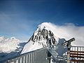
The Crap Masegn is a mountain of the Glarus Alps, located near Flims in the canton of Graubünden, Switzerland. It lies south of the Vorab. Territorially...
2 KB (162 words) - 17:20, 16 April 2022

several modernised chairlifts. A more recent aerial cable car was built to Crap Masegn, from where another gondola lift leads to the glacier at Vorab, which...
3 KB (394 words) - 01:01, 2 May 2022
Jakobshorn Chur - Känzeli (opened 2006) Naraus - Cassonsgrat Laax - Crap Sogn Gion - Crap Masegn Disentis - Caischavedra Arosa - Weisshorn Arosa - Lenzerheide...
8 KB (622 words) - 21:59, 8 August 2024

Retrieved 9 August 2018. Die Wetterstation liegt in etwa 2500 m Höhe am Crap Masegn. "Vorbericht der Schweizerischen Sicherheitsuntersuchungsstelle SUST"...
27 KB (3,111 words) - 11:00, 3 October 2024

of Ladir and the exclave alpine settlement of Dadens da Ladir on the Crap Masegn mountain. The municipality does actually not reach the plain in the valley...
7 KB (731 words) - 22:59, 22 March 2024
09°20′35″E / 47.24944°N 9.34306°E / 47.24944; 9.34306 Unnamed summit on Crap Masegn 2472 60 2472 Cable car Graubünden 46°50′33″N 09°10′48″E / 46.84250°N...
14 KB (299 words) - 17:25, 15 March 2023

cable cars and upland areas taken out in preparation for the storm. Crap Masegn, Graubünden, with a peak of 165 km/h (103 mph) in the Alps, though even...
27 KB (2,833 words) - 22:46, 10 March 2024