
Eagle Pass is a city in and the county seat of Maverick County in the U.S. state of Texas. Its population was 28,130 as of the 2020 census. Eagle Pass...
27 KB (2,459 words) - 19:26, 1 September 2024

Operation Lone Star (redirect from Standoff at Eagle Pass)
cities. In January 2024, Texas officials seized control of Shelby Park in Eagle Pass, which was frequently used by United States Border Patrol to process new...
76 KB (6,267 words) - 03:39, 7 September 2024
Eagle Pass may refer to: Eagle Pass (Coconino County, Arizona), Coconino County, Arizona Eagle Pass (Graham County, Arizona), Graham County, Arizona Eagle...
1 KB (163 words) - 13:17, 18 September 2022

Maverick County, Texas (redirect from Eagle Pass, TX μSA)
is Eagle Pass. The county was created in 1856 and organized in 1871. It is named for Samuel Maverick, cattleman and state legislator. The Eagle Pass, TX...
31 KB (3,031 words) - 18:03, 29 June 2024
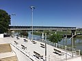
the Rio Grande River in downtown Eagle Pass, Texas, U.S. The park is owned and maintained by the City of Eagle Pass. It was created using Federal Emergency...
3 KB (314 words) - 13:08, 15 February 2024

cities of Eagle Pass, Texas, and Piedras Negras, Coahuila. The bridge is also known as "Eagle Pass Bridge 1" and "Puente Piedras Negras-Eagle Pass". The road...
6 KB (268 words) - 02:34, 11 May 2024
Eagle Pass Independent School District is a public school district based in Eagle Pass, Texas (USA). The district's boundaries parallel that of Maverick...
3 KB (220 words) - 15:50, 23 April 2023

Eagle Pass (elevation 550 metres or 1,804 feet) is a mountain pass through the Gold Range of the Monashee Mountains in British Columbia, Canada. It divides...
2 KB (139 words) - 05:46, 25 July 2024

coordinates) Eagle Pass Army Airfield is a former World War II military airfield complex. It is located 10.6 miles (17.1 km) north of Eagle Pass, Texas. It...
15 KB (1,620 words) - 20:12, 28 August 2024
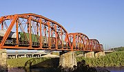
Union Pacific International Railroad Bridge (redirect from Eagle Pass Union Pacific International Railroad Bridge)
international bridge that crosses the U.S.-Mexico border between the cities of Eagle Pass, Texas, and Piedras Negras, Coahuila. The U.S. portion is owned and operated...
2 KB (134 words) - 07:37, 13 November 2023
Fort Duncan (section Camp at Eagle Pass)
the first U.S. settlement on the Rio Grande near the current town of Eagle Pass, Texas. A line of seven army posts was established in 1848–49 after the...
11 KB (1,129 words) - 21:24, 25 April 2024

Eagle Pass Municipal Airport is a former airport, located in Eagle Pass, Texas. Airport operations ended around 1998, being transferred to the Maverick...
6 KB (596 words) - 15:34, 13 January 2024

The Eagle Pass Camino Real Port of Entry (sometimes called "Eagle Pass II") is located on the United States–Mexico border at the Camino Real International...
2 KB (90 words) - 19:26, 27 January 2024

The Eagle Pass Port of Entry on the United States–Mexico border was established around 1896. The first carriage bridge connecting Eagle Pass, Texas, with...
2 KB (167 words) - 19:23, 27 January 2024
700 m2) manufacturing plant in the Eagle Pass Industrial Park in the state of Texas. Mossberg greatly enlarged the Eagle Pass production facility in 2013 to...
11 KB (1,105 words) - 06:24, 6 March 2024

Coahuila on the Mexico–United States border, across the Rio Grande from Eagle Pass in the U.S. state of Texas. In the 2015 census the city had a population...
37 KB (3,578 words) - 23:44, 12 August 2024

For the military use of the airport, see Eagle Pass Army Airfield Maverick County Memorial International Airport (IATA: EGP, FAA LID: 5T9) is a county-owned...
2 KB (155 words) - 15:34, 13 January 2024

Kickapoo Traditional Tribe of Texas (redirect from Lucky Eagle Casino and Hotel)
The Kickapoo Traditional Tribe of Texas, based in Eagle Pass, is a federally recognized tribe that uses revenue from its gaming and business operations...
10 KB (639 words) - 07:20, 29 April 2024

US 57 begins at the Eagle Pass – Piedras Negras International Bridge in Eagle Pass. The highway travels eastward through Eagle Pass on Garrison Street. On...
8 KB (603 words) - 14:16, 18 February 2024
Eagle Pass. The Eagle River originates in the mountains west of Revelstoke and flows west and southwest, entering Shuswap Lake at Sicamous. The Eagle...
1,008 bytes (109 words) - 16:36, 28 March 2024
23833°W / 30.13778; -103.23833 US 277 north (Eagle Pass/Carrizo Springs) – 30 miles east-southeast of Eagle Pass – 28°37′33″N 100°03′33″W / 28.62583°N 100...
23 KB (3,187 words) - 05:40, 28 June 2024
KINL is a radio station based in Eagle Pass, Texas. The station broadcasts at 92.7 MHz with an ERP of 20,000 watts. KINL signed on November 2, 1971 as...
2 KB (179 words) - 06:46, 7 September 2024

U.S. Route 277 (redirect from U.S. Route 277 Business (Eagle Pass, Texas))
of Laredo. The highway runs in an east-west direction, until reaching Eagle Pass. From here to Del Rio, the highway parallels the Rio Grande at the U.S...
31 KB (1,259 words) - 12:05, 24 April 2024

Colorado State Highway Department from 1930 to 1945. Vail Pass lies on the boundary between Eagle and Summit counties, between Vail on the west and Copper...
6 KB (506 words) - 21:50, 22 June 2023
(disambiguation) Eagle Pass (disambiguation) Eagle River (disambiguation) Eagle Nebula Eagle (crater), landing spot on Mars of the rover Opportunity The Eagle (1918...
9 KB (1,164 words) - 02:22, 23 August 2024
Eagle Pass (el. 7,464 ft/2,275 m) is a high mountain pass in Lake County, Montana in the United States. It is called nšt̓ew̓s sx̣ʷcusi in Salish, or "Standing...
1 KB (103 words) - 09:02, 21 October 2020

overlays with 682 (1953) 830: Uvalde, New Braunfels, Kerrville, Boerne, Eagle Pass and southwest Texas (July 30, 1997) 832: Houston area, overlays with 281...
6 KB (394 words) - 03:25, 3 October 2023

Cost, Cotulla, Crystal City, D'Hanis, Del Rio, Devine, Dilley, Doss, Eagle Pass, Ecleto, El Indio, Falls City, Fischer, Floresville, Fowlerton, Fredericksburg...
7 KB (436 words) - 22:40, 28 May 2024
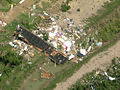
struck the border cities of Piedras Negras, Coahuila (rated F4), and Eagle Pass, Texas (rated EF3), along the United States-Mexican border on April 24...
87 KB (3,600 words) - 20:41, 7 September 2024
States-Mexico border cities of Eagle Pass, Texas, and Piedras Negras, Coahuila. The bridge is also known as "Eagle Pass-Piedras Negras International Bridge...
6 KB (276 words) - 19:21, 27 January 2024