
New York City's borough of Staten Island. Precise parameters vary, but the most commonly used definition of the East Shore is that it stretches from the...
5 KB (638 words) - 05:36, 9 February 2023

The South Shore is a geographical term applied to the area in the New York City borough of Staten Island, south and east of the island's ridge of hills...
6 KB (665 words) - 13:59, 26 May 2024
West Shore refers to the section of the New York City borough of Staten Island that borders the Arthur Kill, between the Staten Island Expressway and...
6 KB (666 words) - 20:09, 21 January 2024

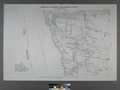
Staten Island (/ˈstætən/ STAT-ən) is the southernmost borough of New York City, coextensive with Richmond County and situated at the southernmost point...
160 KB (16,767 words) - 06:16, 27 September 2024
the city of New Haven, Connecticut East Shore, Staten Island, a region in the New York City borough of Staten Island This disambiguation page lists articles...
286 bytes (76 words) - 20:15, 10 March 2015
Shore Acres is a small neighborhood of Staten Island, one of the five boroughs of New York City. It is situated along the Upper New York Bay, just north...
2 KB (238 words) - 00:09, 13 July 2023

The Staten Island Railway (SIR) is a railroad line in the New York City borough of Staten Island. It is owned by the Staten Island Rapid Transit Operating...
98 KB (8,799 words) - 13:35, 12 September 2024
Staten Island, New York, on the island's South Shore. It is located to the north of Woodrow, to the west of Arden Heights, and to the south and east of...
23 KB (2,449 words) - 14:29, 30 June 2024

The East Shore Seawall, also known as Staten Island Multi-Use Elevated Promenade, is a 5.2-mile (8.4 km) long combined seawall and esplanade proposed...
10 KB (817 words) - 16:39, 2 April 2024

New Dorp (/ˈnjuːdɔːrp/ NEW-dorp) is a neighborhood on the South Shore of Staten Island, New York City, United States. New Dorp is bounded by Mill Road...
32 KB (3,520 words) - 06:21, 19 August 2024
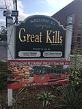
borough of Staten Island in New York City. It is located on the island's South Shore, and according to many local geographers, it is the South Shore's northernmost...
37 KB (3,746 words) - 10:50, 19 June 2024
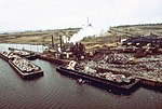
Fresh Kills Landfill (redirect from Staten Island Transfer Station)
Landfill was a landfill covering 2,200 acres (890 ha) in the borough of Staten Island in New York City, United States. The name comes from the landfill's...
28 KB (3,279 words) - 13:50, 24 September 2024

neighborhood of Staten Island, one of the five boroughs of New York City. It is bounded by Westerleigh in the West, West Brighton in the East, Port Richmond...
4 KB (494 words) - 08:27, 16 June 2024
tall hill formed of serpentine rock on Staten Island, New York. It is the second highest natural point on the island and in the five boroughs of New York...
25 KB (2,933 words) - 12:24, 26 June 2024
fall within Mid-Island as their ZIP Code is 10314. Like all of Staten Island except for the North Shore, farms dominated the Mid-Island region until the...
6 KB (571 words) - 15:59, 16 January 2024

Annadale is a middle-class neighborhood on the South Shore of the borough of Staten Island in New York City. The community received its present name circa...
3 KB (382 words) - 12:36, 11 April 2023

neighborhood, centered around the street of the same name, on the East Shore of Staten Island, one of the five boroughs of New York City. It is represented...
3 KB (442 words) - 12:40, 19 November 2022

Tottenville is a neighborhood on the South Shore of Staten Island, New York City. It is the southernmost neighborhood and settlement in both New York City...
35 KB (3,749 words) - 17:40, 29 July 2024

The Staten Island Ferry is a fare-free passenger ferry route operated by the New York City Department of Transportation. The ferry's single route runs...
154 KB (16,415 words) - 05:09, 9 August 2024

the North Shore of Staten Island in New York City, United States. It is an older waterfront neighborhood, facing Upper New York Bay on the east. It is bordered...
19 KB (2,314 words) - 16:50, 4 July 2024
on Staten Island's northeastern shore, bounded to the south by Victory Boulevard, to the west by Sailors' Snug Harbor, and to the north and east by the...
89 KB (9,476 words) - 13:38, 31 July 2024
on Staten Island, New York City, measuring approximately 8.0 miles (12.87 km). It stretches from the West Shore community of Travis to the upper East Shore...
9 KB (837 words) - 00:46, 4 September 2024

neighborhood of Staten Island, New York City, situated in the central area of North Shore. The neighborhood is bordered by New Brighton to the east, Port Richmond...
16 KB (1,700 words) - 01:10, 2 April 2024

Huguenot is a neighborhood on the South Shore of Staten Island, New York City. Originally named "Bloomingview", it was later named for the Huguenots, led...
6 KB (497 words) - 01:59, 26 May 2024

in Staten Island, New York, United States. Some of them are the direct descendants of streetcar lines (see list of streetcar lines in Staten Island). Many...
70 KB (2,196 words) - 19:19, 15 September 2024
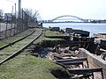
North Shore Branch is a partially abandoned branch of the Staten Island Railway in New York City, which operated along Staten Island's North Shore from...
53 KB (5,352 words) - 02:47, 8 September 2024
City's borough of Staten Island. It is located on the island's South Shore, with Tottenville to the south, Pleasant Plains to the East, Rossville to the...
12 KB (1,526 words) - 13:00, 21 February 2023

The Staten Island Tunnel is an abandoned, incomplete railway and subway tunnel in Staten Island, New York City. It was intended to connect railways on...
57 KB (5,988 words) - 23:14, 6 May 2024

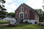
Woodrow is a neighborhood located on the South Shore of Staten Island, New York, United States. The neighborhood is represented in the New York State Senate...
4 KB (516 words) - 14:31, 26 February 2023

the North Shore of Staten Island, a borough of New York City. Port Richmond is bounded by Kill van Kull on the north, Clove Road on the east, Forest Avenue...
46 KB (5,769 words) - 13:50, 23 May 2024