
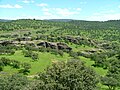
‹ The template Infobox settlement is being considered for merging. › East Sonora is a census-designated place (CDP) in Tuolumne County, California, United...
11 KB (949 words) - 05:03, 10 July 2023

Sonora (Spanish pronunciation: [soˈnoɾa] ), officially Estado Libre y Soberano de Sonora (English: Free and Sovereign State of Sonora), is one of the...
164 KB (19,709 words) - 23:54, 10 July 2024

Sonora is the county seat of Tuolumne County, California, United States. Founded during the California Gold Rush by Mexican miners from Sonora (after which...
26 KB (2,112 words) - 15:10, 16 July 2024

Tuolumne County, California (redirect from Sonora, California micropolitan area)
55,620. The county seat and only incorporated city is Sonora. Tuolumne County comprises the Sonora, CA Micropolitan Statistical Area. The county is in the...
50 KB (2,127 words) - 15:22, 16 July 2024

Pacific Crest Trail. The pass connects the communities of Sonora to the west and Bridgeport to the east. Like Ebbetts Pass to the north and Tioga Pass to the...
11 KB (789 words) - 09:38, 2 July 2024

Confidence East Sonora Groveland-Big Oak Flat Jamestown Mi-Wuk Village Moccasin Mono Vista Phoenix Lake-Cedar Ridge Pine Mountain Lake Sonora Soulsbyville...
12 KB (640 words) - 05:15, 12 July 2024

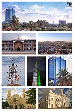
the capital city is Hermosillo. Sonora is located in Northwest Mexico, bordered by the states of Chihuahua to the east, Baja California to the northwest...
45 KB (5,840 words) - 16:34, 19 June 2024

Sonoran Desert (redirect from Sonora desert)
(Spanish: Desierto de Sonora) is a hot desert in North America and ecoregion that covers the northwestern Mexican states of Sonora, Baja California, and...
29 KB (2,352 words) - 03:21, 24 June 2024

Sonora Island is one of the outer islands (without ferry service) of the Discovery Islands of British Columbia, Canada. It is located at the eastern end...
5 KB (408 words) - 18:39, 28 January 2023
its surrounding municipality of the same name, in the Mexican state of Sonora. An approximate population for Yécora is 3171. In 1673, the Jesuit missionary...
10 KB (345 words) - 17:21, 24 May 2024
Tepache is a small town in Tepache Municipality in the east of the Mexican state of Sonora. Its location by GPS coordinates is at: Longitude (dec): -109...
7 KB (702 words) - 07:46, 8 July 2024
is a Mexican town in Naco Municipality located in the northeast part of Sonora state on the border with the United States. It is directly across from the...
26 KB (2,518 words) - 14:59, 9 July 2024

The seventh federal electoral district of Sonora (Distrito electoral federal 07 de Sonora) is one of the 300 electoral districts into which Mexico is...
11 KB (559 words) - 22:55, 19 July 2024

of Sonora. SR 49 splits from SR 108 and enters downtown Sonora as Stockton Street, turning north onto Washington Street before leaving the Sonora city...
36 KB (2,930 words) - 12:41, 26 April 2024

Puerto Peñasco (redirect from Puerto Penasco, Sonora)
in Puerto Peñasco Municipality in the northwest of the Mexican state of Sonora, 100 kilometres (62 mi) from the border with the U.S. state of Arizona....
38 KB (3,339 words) - 21:23, 27 June 2024

breeds from south east Utah and south west Colorado through mountains of west Texas, Arizona and New Mexico (less north east) to east Sonora, Chihuahua, and...
29 KB (3,548 words) - 15:32, 17 February 2024
and Sonora Road, east of Springdale. The upper reaches of Beaver Lake on the White River lie less than two miles to the east and south. "Sonora, Arkansas"...
3 KB (84 words) - 20:57, 8 July 2024

California State Route 108 (redirect from Long Barn to Sonora Road)
that runs from the Central Valley and across the Sierra Nevada via the Sonora Pass. It generally runs northeast from downtown Modesto near the SR 99/SR...
14 KB (1,103 words) - 00:22, 17 December 2023

Interstate 205 through Manteca. In east Manteca the freeway ends at SR 99 and becomes a highway which continues to head east through Escalon, Oakdale and other...
22 KB (1,550 words) - 08:30, 24 May 2024

Desierto de Sonora, just east-southeast of Sonoyta. Its population was 1,188 in the 2010 census. Neighboring municipalities are Caborca to the east and Puerto...
8 KB (287 words) - 04:47, 26 September 2023
County 93622 East Sonora 1 Tuolumne County East Stockton 1 San Joaquin County 95205 East Tulare 1 Tulare County 93274 East Tustin 1 Orange...
24 KB (77 words) - 02:32, 9 April 2024

Susan Roces (redirect from Jesusa Sonora)
Jesusa Purificacion Levy Sonora-Poe (July 28, 1941 – May 20, 2022), known professionally as Susan Roces (Tagalog pronunciation: [ˈɾɔsɛs]), was a Filipino...
29 KB (1,677 words) - 05:19, 5 July 2024
Hermosillo (redirect from Hermosillo, Sonora)
del Pitic), is a city in the center of the northwestern Mexican state of Sonora. It is the municipal seat of the Hermosillo municipality, the state's capital...
69 KB (7,457 words) - 16:16, 24 June 2024
Bacanora is a small town in Bacanora Municipality in the east of the Mexican state of Sonora. It is located at the geographical coordinates of 28°59′N...
4 KB (428 words) - 20:05, 30 April 2024

Moctezuma is a municipio (municipality) of the Mexican state of Sonora, located in the state's central region. It is also the name of its largest settlement...
4 KB (411 words) - 18:20, 1 May 2024
Ogden's Landing. Gridiron lay along the east bank of the river 47 miles (76 km) below what is now the Sonora/Mexico—Arizona/U.S. border. Steamboat transport...
3 KB (236 words) - 08:18, 26 November 2021
converted a tin beer distribution warehouse into a rustic 99-seat theater in East Sonora where their first performance was an adaptation of Dracula in February...
4 KB (446 words) - 04:19, 2 November 2022

Sierra Madre Occidental in eastern Sonora. It borders the municipalities of Huásabas to the north, Bacadéhuachi to the east, Divisaderos to the south, and...
14 KB (741 words) - 04:48, 17 June 2024

Álamos (redirect from Álamos, Sonora)
(Spanish: ['alamos] ) is a town in Álamos Municipality in the Mexican state of Sonora, in northwestern Mexico. Historically an important center of silver mining...
19 KB (1,604 words) - 16:57, 15 May 2024
March and returns at 2 am MDT to 1 am MST on the first Sunday in November. Sonora in Mexico and most of Arizona in the United States do not observe daylight...
10 KB (1,024 words) - 18:46, 27 June 2024