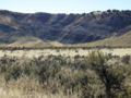
Fremont Wash sometimes called Fremont Canyon in its upper reach, is a stream and a valley in the north end of Parowan Valley, in Iron County, Utah. Its...
3 KB (376 words) - 06:20, 15 March 2023
Fremont Canyon is a stream and a deep valley or canyon that runs from its mouth at its confluence with Coyote Creek at the head of Fremont Wash in Iron...
746 bytes (109 words) - 21:07, 29 July 2017
Fremont Canyon may refer to: A tributary of Santiago Creek in Orange County, California Fremont Canyon (Utah), and the upper part of Fremont Wash in Iron...
825 bytes (88 words) - 22:26, 21 April 2021

Pass to a crossing just below the Lower Narrows of the river. John C. Frémont intercepted this route to the river, riding east southeast from Lake Elizabeth...
18 KB (1,817 words) - 19:32, 26 June 2024

John Charles Frémont (January 21, 1813 – July 13, 1890) was an American explorer, military officer, and politician. He was a United States senator from...
152 KB (17,435 words) - 00:45, 3 October 2024
Utah. It lies south of Nevershine Hollow and north of the canyon of Fremont Wash. It reaches an elevation of 6,552 feet (1,997 meters). Beaver Ridge is...
1 KB (180 words) - 13:18, 23 January 2023

Mescal Creek Le Montaine Creek Kelso Wash Mojave River Manix Wash Daggett Wash Wild Wash Buckthorn Wash Fremont Wash West Fork Mojave River Grass Valley...
69 KB (5,982 words) - 14:57, 24 June 2024

terrain in Nevershine Hollow and over Beaver Ridge into the canyon of Fremont Wash, rejoining the original road above Muley Point. This road became a winter...
24 KB (2,194 words) - 00:17, 17 July 2024
meters). It overlooks the northern end of the Parowan Valley, where Fremont Wash enters it. U.S. Geological Survey Geographic Names Information System:...
418 bytes (64 words) - 13:19, 23 January 2023
terrain in Nevershine Hollow and over Beaver Ridge into the canyon of Fremont Wash that rejoined the original road above Muley Point. U.S. Geological Survey...
1 KB (194 words) - 13:19, 23 January 2023
Its lowest point is at 5,695 feet (1,736 m) in the Little Salt Lake. Fremont Wash, Red Creek, Parowan Creek and other tributaries all drain into the Little...
2 KB (116 words) - 16:58, 18 December 2023

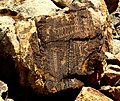
of Thompson Springs. It contains art from three different cultures: the Fremont, the Ute, and the Barrier Canyon Style. It has been listed on the National...
4 KB (261 words) - 18:13, 6 July 2024
Lake originally was a seasonal, shallow, brackish sink fed by springs, Fremont Wash and streams emerging from the Hurricane Cliffs in the Parowan Valley...
3 KB (282 words) - 10:46, 2 April 2023
terrain in Nevershine Hollow and over Beaver Ridge into the canyon of Fremont Wash that rejoined the original road above Muley Point. U.S. Geological Survey...
1 KB (187 words) - 22:39, 26 July 2024
terrain in Nevershine Hollow and over Beaver Ridge into the canyon of Fremont Wash to Muley Point.: 2, 4 U.S. Geological Survey Geographic Names Information...
1 KB (198 words) - 13:19, 23 January 2023
route between the Virgin River at Halfway Wash to Resting Springs, following the cutoff discovered by John Frémont on his return from California in 1844....
30 KB (2,642 words) - 19:38, 11 March 2024
List of rivers of Utah (redirect from Miry Wash)
Montezuma Creek McElmo Creek Escalante River Coyote Gulch Dirty Devil River Fremont River Sulphur Creek Sand Creek Muddy Creek Green River San Rafael River...
5 KB (416 words) - 17:34, 2 June 2024

Buckhorn Draw Pictograph Panel (redirect from Buckhorn Wash Rock Art Sites)
Style panel, there are a few later petroglyphs of Fremont culture origin as well. In many cases the Fremont painted figures on top of the older Barrier Canyon...
2 KB (156 words) - 18:53, 10 October 2023

The Courthouse Wash Pictographs are a series of large pictographs created over a long period of time, located on a sheltered sandstone wall at the mouth...
4 KB (350 words) - 04:37, 6 August 2023

in Grand Wash produced uranium ore. By 1920 no more than ten families at one time were sustained by the fertile flood plain of the Fremont River and...
41 KB (4,265 words) - 11:28, 2 October 2024
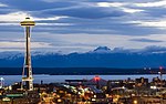
Seattle (redirect from Seattle, Wash.)
the 4th district consists of the northwestern neighborhoods of Ballard, Fremont, Magnolia, and Queen Anne; and the 8th district includes Downtown Seattle...
236 KB (20,246 words) - 21:51, 10 September 2024
American School (economics) (redirect from Blain wash)
the careers of Major Stephen Harriman Long and Major General John C. Frémont), almost always under the direction of an officer from the Army Corps of...
51 KB (6,082 words) - 16:44, 21 September 2024

accompanied by a video directed by Jules Renault of 360 Creative and produced by Frémont & Co. The clip tells the story of a love affair played out by actors, with...
14 KB (1,112 words) - 22:34, 2 August 2024

Cle Conejos Cost Crow Cust Delta Den Dolores Doug Eagle Elbert El Paso Fremont Garfield Gil Grand Gunnison Hins Huerfano Jacks Jef Kiowa Kit Carson Lake...
16 KB (299 words) - 00:58, 1 August 2024

beautiful pictographs were left in Thompson Canyon. Subsequent Anasazi, Fremont, and Ute tribes have also left their mark upon the area. The site of this...
13 KB (1,373 words) - 18:46, 24 December 2023

Puget Sound (redirect from Puget Sound, Wash.)
Washington Ship Canal Works Ballard Locks Carl S. English Jr. Botanical Gardens Fremont Cut Montlake Cut Landforms Lake Washington Portage Bay Lake Union Salmon...
53 KB (4,951 words) - 22:09, 26 September 2024
Morrison Formation (redirect from Salt Wash Member)
Morrison in eastern Colorado. It appears analogous to the Tidwell and Salt Wash Members. This reclassification is supported by more detailed examination...
35 KB (3,496 words) - 22:01, 16 July 2024

in 1848. The name of the trail comes from the publication of John C. Frémont’s Report of his 1844 journey (which crossed into Mexico) for the U.S. Topographical...
32 KB (3,688 words) - 05:13, 28 September 2024

southern Swell is drained mainly by Muddy Creek, which eventually joins the Fremont River to become Dirty Devil River northeast of Hanksville, Utah. The Dirty...
12 KB (1,207 words) - 16:40, 30 July 2024

The culture received its name from the Fremont River, where the first Fremont sites were discovered. The Fremont River in Utah flows from the Johnson Valley...
27 KB (2,691 words) - 01:17, 1 May 2024