
made its way into the English language by the same route, from the German Geotop.) The concept of a biotope was first advocated by Ernst Haeckel (1834–1919)...
14 KB (1,688 words) - 05:14, 22 March 2024

marking a property boundary, and so forth. It is a loanword from German (Geotop) in the study of ecology and might be the model for many other similar words...
2 KB (235 words) - 20:37, 6 November 2022

Bayerisches Landesamt für Umwelt, Geotop Ossersattel (retrieved 11 December 2017) Bayerisches Landesamt für Umwelt, Geotop Kleiner Osser (retrieved 11 December...
8 KB (810 words) - 17:59, 11 September 2023

Henning Zellmer (2008). 12. Internationale Jahrestagung der Fachsektion GeoTop der Deutschen Gesellschaft für Geowissenschaften: 30. April bis 4. Mai 2008...
38 KB (4,183 words) - 17:37, 5 April 2024

binge-drinkers. Since 2006 the Externsteine site has been a Nationaler Geotop [de] (national geotope).: 27 H. Beck, J. Udolph, "Externsteine: Namenkundliches"...
30 KB (3,925 words) - 10:17, 26 May 2024

für Umwelt retrieved 16 January 2009 Bayerisches Landesamt für Umwelt, Geotop Buchberger Leite NE von Buchberg (retrieved 1 November 2017). Bavarias schönste...
3 KB (366 words) - 20:14, 3 July 2023

interuniversitaire québécois de formation avancée et de recherche en sciences du globe (GÉOTOP) (Quebec Inter-institution Network for Advanced Education and Research in...
24 KB (2,721 words) - 22:02, 4 September 2023
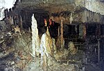
Kempe: Welt voller Geheimnisse – Höhlen. pp. 102. Siehe auch: Literatur. "Geotop: König-Otto-Tropfsteinhöhle bei St. Colomann (Schauhöhle)". "Millionth visitor...
19 KB (2,439 words) - 18:15, 2 December 2023
Academy of Sciences "Passing of paleontologist Hans J. Hofmann (1936-2010)". GEOTOP. 2010. Archived from the original on 16 November 2019. Retrieved 19 January...
4 KB (330 words) - 10:55, 19 March 2023

(comprehensive description of the spring) Gewässerkunde Fichtelgebirge: Seehausbrunnen Geotop: Weissmainquelle (retrieved 26 August 2013; pdf; 192 kB)...
3 KB (311 words) - 14:00, 12 May 2021
Bayern 1:25.000, Kartenblat 5933 Weismain "Bayerisches Landesamt für Umwelt, Geotop Bayerisches Landesamt für Umwelt, Bärental NE von Wunkendorf". Böhm (2000)...
13 KB (1,354 words) - 04:21, 17 June 2024
Röhling, H. Zellmer (Hrsg.): GeoTop 2008 „Landschaft lesen lernen“ – 12. Internationale Jahrestagung der Fachsektion GeoTop der Deutschen Gesellschaft für...
47 KB (5,766 words) - 09:26, 7 July 2024

Retrieved 2018-01-14.[permanent dead link] Bayerisches Landesamt für Umwelt, Geotop Gipfelklippe des Großen Falkenstein SE von Zwieslerwaldhaus (retrieved 18...
6 KB (457 words) - 06:41, 26 June 2024

cz (in Czech). Retrieved 2023-01-09. Bayerisches Landesamt für Umwelt, Geotop Gipfelklippen am Dreisesselberg (retrieved 10 December 2017). Bayerns schönste...
7 KB (694 words) - 14:32, 9 January 2023

Wanderführer in die Unterwelt der Fränkischen Schweiz mit neuen Touren, S. 61–63. Geotop: Sophienhöhle bei Rabenstein (Schauhöhle). (PDF; 284 kB) retrieved 26 August...
40 KB (5,478 words) - 22:30, 18 January 2024

devoted to topological aspects of knotted fields. He is a founding member of GEOTOP-A, an international web-seminar series that was launched in 2018 to promote...
19 KB (2,080 words) - 05:27, 13 July 2024
Atlas") by the Bavarian State Government Bayerisches Landesamt für Umwelt, Geotop Gipfelklippen des Großen Rachel (retrieved 18 October 2017). Wikimedia Commons...
5 KB (534 words) - 20:45, 16 April 2022

have been erected here. Bayerisches Landesamt für Denkmalpflege: Entry Geotop: Felsen an der Burgruine Altenstein (retrieved 14 October 2013; pdf; 279 kB)...
5 KB (527 words) - 00:25, 30 October 2022

German) Geotop: Ehrenbuergfelsen am Walberla-Berg (Katasternummer 474R037), (retrieved 22 March 2020). Bayerisches Landesamt für Umwelt, Geotop Steinerne...
20 KB (2,311 words) - 09:15, 28 February 2024

John Davey Grand Prix Pages "Hortulus Monheimensis". 27 September 2009. Geotop 176Q009 Gailachquelle in Muehlheim (in German) Official Monheim website...
14 KB (1,802 words) - 23:05, 25 March 2023
construction of the Hindenburgdamm. In 2006, the Kliff was declared a Nationaler Geotop [de] (national geotope).: 258 In the past there have been several attempts...
10 KB (1,132 words) - 13:27, 26 December 2022

Regierungsbezirk Karlsruhe. Karlsruhe, 2000. pages 125 ff. (pdf; 5.6 MB) LGRB: Geotop-Steckbrief Aufg. Steinbruch Waldeneck (Peter'scher Bruch) im Iburg-Wald...
6 KB (586 words) - 18:53, 28 December 2023
1997–1999) of The Centre de recherche en géochimie et géodynamique, or GEOTOP. He served twice as Chairman of the Department of Earth Sciences at UQAM...
6 KB (685 words) - 21:32, 13 May 2023
standard and was calibrated by measurements at three selected laboratories (GEOTOP-UQAM in Montreal, Canada; USGS in Reston, USA; MPI-BGC in Jena, Germany)...
83 KB (7,253 words) - 14:23, 12 July 2024

Kommission ISBN 978-3-9816597-7-1. Retrieved 19 March 2019. Nationaler Geotop – List of the most notable geological localities in Germany. (in German)...
30 KB (3,310 words) - 09:02, 14 July 2024

Rock Garden – Wonsees". schlosser.bayern.de. Retrieved 17 September 2022. "Geotop: Felsengarten Sanspareil" (PDF). umwelt.bayern.de. Retrieved 16 September...
38 KB (4,534 words) - 18:55, 4 February 2024

2 m), 400 m south-southeast of Obergröningen Map services of the Federal Agency for Nature Conservation Geotop-Kataster des Landes Baden-Württemberg....
5 KB (520 words) - 12:54, 13 July 2020

slide. On 12 May 2006, this area was included to the list of National Geotops. Other major landslides occurred, also after previous heavy rainfall, on...
27 KB (3,340 words) - 10:53, 10 October 2022

Commission de toponymie du Québec. Open Street Map - Accessed February 5, 2019 "geotop.ca" (PDF). Archived from the original (PDF) on 2016-03-03. Retrieved 2019-12-28...
8 KB (798 words) - 23:55, 15 December 2021