
maintenance of the river. The river opens out into a transitory lake called Kentmere Tarn just south of the confluence with Hall Gill. The lake has at times in...
29 KB (3,981 words) - 16:48, 23 August 2024

on the western side of Harter Fell beneath the Nan Bield Pass. After Kentmere Tarn was drained to provide agricultural land in the 1840s, water supply...
25 KB (3,487 words) - 22:13, 28 November 2023
Hall Tarn, south-east of Torver Kentmere Reservoir Knipe Tarn, south-east of Bowness-on-Windermere Lanty's Tarn, west of Patterdale Launchy Tarn, on Dale...
33 KB (1,299 words) - 16:28, 17 February 2023
minor road to the settlement of Kentmere, and in then joined by Hall Gill. It broadens out as it flows through Kentmere Tarn, which was drained in the early...
59 KB (7,784 words) - 17:24, 26 June 2024

Sallows (category Kentmere)
the valleys of Kentmere and Troutbeck. It is the highest point in the upland area to the south of Garburn Pass, variously termed Kentmere Park and Applethwaite...
4 KB (511 words) - 20:59, 23 April 2023

west by Kentmere Pike and Shipman Knotts, one arm of the Kentmere Horseshoe, and to the east by Sleddale Fell and its summits of Grey Crag and Tarn Crag;...
10 KB (1,046 words) - 14:00, 10 June 2024
Harter Fell (Mardale) (category Kentmere)
ridge passes over The Knowe and then Brown Howe, before connecting to Kentmere Pike. The eastern branch includes the rocky top of Little Harter Fell (2...
6 KB (771 words) - 18:10, 14 July 2024

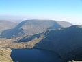
Kentmere, Nan Bield provides the obvious route, although a pathless climb up to the top of Lingmell End is possible. Blea water is the deepest tarn but...
4 KB (466 words) - 19:19, 25 December 2023
Street High Tove Hindscarth Holme Fell Hopegill Head Ill Bell Illgill Head Kentmere Pike Kidsty Pike Kirk Fell Knott Knott Rigg Knott, The Lank Rigg Latrigg...
23 KB (2,842 words) - 18:49, 25 May 2024

Green Quarter Fell (category Kentmere)
Kentmere, reaching the summit of Hollow Moor at 1,394 feet (425 m) and a nameless summit at 1,370 feet (420 m) and making a detour to admire the tarn...
1 KB (132 words) - 09:50, 12 June 2023

Yoke (Lake District) (category Kentmere)
the Kentmere Horseshoe, a 19-kilometre (12-mile) walk with 1,100 metres (3,600 foot) of ascent that starts and finishes in the village of Kentmere and...
4 KB (453 words) - 04:17, 9 September 2023

satellites of Wether Hill. To the south of High Street is the valley of Kentmere, with ridges on either flank that make a horseshoe walk. On the western...
9 KB (1,097 words) - 15:34, 8 November 2023

760 m (2,493 ft) Ill Bell, 757 m (2,484 ft) The Knott, 739 m (2,425 ft) Kentmere Pike, 730 m (2,395 ft) Froswick, 720 m (2,362 ft) Branstree, 713 m (2,339 ft)...
66 KB (2,878 words) - 15:00, 12 April 2024
been seen since 2016. High Street can also be climbed from Patterdale, Kentmere and Troutbeck. The full south-to-north traverse of the High Street ridge...
7 KB (701 words) - 08:28, 25 June 2024

List of hill passes of the Lake District (redirect from Floutern Tarn Pass)
from Braithwaite. Styhead Tarn is at 440 metres (1,440 ft) and a short ascent reaches Sty Head Only the Windy Gap to Styhead Tarn section is called Aaron...
46 KB (2,578 words) - 13:59, 8 January 2024

Shipman Knotts (category Kentmere)
north-east of Kentmere village. Although not one of the best-known Lake District fells (and strictly speaking it is just the southern shoulder of Kentmere Pike)...
4 KB (524 words) - 20:34, 30 March 2024
Reservoir- Devon Jumbles Reservoir - Lancashire Kennick Reservoir- Devon Kentmere Reservoir - Cumbria Kielder Water - Northumberland Killington Reservoir...
19 KB (1,587 words) - 08:29, 30 July 2024

cul-de-sac minor road, as is Longsleddale and the valleys at Haweswater and Kentmere. There are networks of minor roads in the lower-lying southern part of...
96 KB (9,775 words) - 22:09, 3 September 2024

Keisley, Kelbarrow, Keld Kelleth, Kells, Kelsick, Kelton Head, Kendal Kentmere, Kentrigg, Kents Bank, Kershopefoot Keswick Killington, Kilnhill, Kingmoor...
21 KB (1,274 words) - 09:30, 14 March 2024

- Central Fells Cumbria 732 15 2,402 49 89 90 NY288090 N,B,Sy 101 148 Kentmere Pike High Street 34C Lake District - Far Eastern Fells Cumbria 730 39 2...
96 KB (1,917 words) - 14:24, 21 August 2024

Cumbria Coastal Way Cumbria Way Dales Way Pennine Way Meres Buttermere Kentmere Thirlmere Windermere Millom Folk Museum Museum of Lakeland Life & Industry...
74 KB (6,139 words) - 11:11, 9 September 2024
Reservoir west of the town of Ulverston Haweswater Reservoir Hayeswater Kentmere Reservoir Killington Reservoir Meadley Reservoir, by Flat Fell, Ennerdale...
31 KB (2,826 words) - 19:55, 29 July 2024
Kerry 731 96 2,398 315 50C 78 V858854 Sim,Hew,Dil,A,VL,sHu 210 England 80 Kentmere Pike Cumbria 730 39 2,395 128 34C 90 NY465077 Sim,Hew,N,W,B,Sy,Fel 211...
91 KB (1,572 words) - 17:48, 27 January 2024

[56.459267691468;-3.9586516570585 NN794314] Sim 1521 2325 England 80 159 Kentmere Pike 730 39 2,395 128 34C 90 [54.461844852948;-2.8268332101509 NY465077]...
77 KB (1,721 words) - 22:05, 28 September 2023
Sy 116 Low White Stones 34B: LD C&W 731 4 2,398 13 89 90 NY282100 B 117 Kentmere Pike 34C: LD E Wainwright 730 39 2,395 128 90 NY465077 Sim,Hew,N,W,B,Sy...
71 KB (1,095 words) - 18:03, 27 January 2024

Walking the Lake District Fells - Mardale and the Far East: High Street and Kentmere. Cicerone Press. pp. 266–274. ISBN 978-1-78362-813-1. Retrieved 8 February...
3 KB (266 words) - 13:15, 9 May 2023

landscape" The best-known Neolithic site in the West Cumbrian Plain is Ehenside Tarn near Beckermet, with roughout (unfinished) and polished axes, plain bowl...
205 KB (27,907 words) - 16:11, 1 September 2024
HST-5 Harter Fell 778 149 NY459093 HST-6 Ill Bell 757 124 NY436077 HST-7 Kentmere Pike 730 39 NY465077 HST-8 Froswick 720 75 NY435085 HST-9 Branstree 713...
27 KB (182 words) - 11:14, 11 November 2023

the Duddon Basin, the Scafell Caldera, the Haweswater Caldera and the Kentmere succession. These are all followed by volcaniclastic sandstone of the Seathwaite...
42 KB (5,024 words) - 00:00, 18 December 2023