
Kentucky Route 313 (KY 313) is a 33.8-mile-long (54.4 km) state highway in the U.S. state of Kentucky. The highway connects rural areas of Hardin and...
11 KB (663 words) - 16:59, 24 April 2024

highway that runs from Kentucky Route 32 just east of Elliottville to Kentucky Route 7 at Green via Ault and Gimlet. Kentucky Route 505 (KY 505) is a 18...
113 KB (5,096 words) - 23:22, 14 May 2024

systems. Kentucky Route 600 is a 2.728-mile-long (4.390 km) state highway in Muhlenberg County that runs from Kentucky Route 831 to Kentucky Route 171 northwest...
109 KB (6,845 words) - 04:26, 3 May 2024

have portions within the State Primary and State Secondary systems. Kentucky Route 200 is a 18.041-mile-long (29.034 km) rural secondary highway that traverses...
91 KB (9,054 words) - 18:30, 9 May 2024

Radcliff and to the northwest by Meade County. Kentucky Route 144 is the city's Main Street, and Kentucky Route 313 (Joe Prather Highway) runs through the northern...
9 KB (766 words) - 14:10, 2 June 2024

terminus at KY 313 south of Hog Wallow. KML file (edit • help) Template:Attached KML/Kentucky Route 334 KML is not from Wikidata Kentucky Route 334 is a 21...
95 KB (9,567 words) - 02:37, 9 July 2024

Kentucky Route 79 (KY 79) is a 102-mile-long (164 km) north–south state highway that traverses five counties in west-central Kentucky. It can be seen...
16 KB (910 words) - 23:09, 10 February 2024
Road 313 (former) Kentucky Route 313 Louisiana Highway 313 Maryland Route 313 Maryland Route 313A Minnesota State Highway 313 Mississippi Highway 313 Montana...
3 KB (190 words) - 22:57, 4 April 2024

and KY 313 (By Pass Road). Previously, KY 448 began at Kentucky Route 144 northwest of Buck Grove. However, in August 2016, Kentucky Route 313 was extended...
4 KB (336 words) - 17:51, 16 February 2024
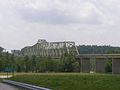
Matthew E. Welsh Bridge (category Buildings and structures in Meade County, Kentucky)
River. The bridge connects Kentucky Route 313 and Indiana State Road 135, as well as the communities of Brandenburg, Kentucky and Mauckport, Indiana. It...
4 KB (204 words) - 07:06, 27 May 2024

Kentucky Route 3521 (KY 3521) is a 1.255-mile-long (2.020 km) rural secondary highway in southern Allen County. The highway begins at the Kentucky–Tennessee...
58 KB (4,880 words) - 19:22, 5 September 2024

Kentucky Route 80 (KY 80) is a 483.55-mile-long (778.20 km) state highway in the southern part of the U.S. state of Kentucky. The route originates on...
64 KB (1,742 words) - 04:20, 25 July 2024

county maintenance through a December 12, 2012, official order. Kentucky Route 1651 is a 10.313-mile-long (16.597 km) rural secondary highway in southern and...
53 KB (5,054 words) - 21:54, 20 January 2024

Kentucky Route 3160 (KY 3160) was a 3.212-mile-long (5.169 km) four-lane divided east–west state highway located entirely in Barren County in the south-central...
4 KB (315 words) - 17:27, 4 November 2023

Route 22, whose continuation into Kentucky Bend at one time was signed as Kentucky State Route 313. According to the U.S. Census Bureau, the Kentucky...
14 KB (1,128 words) - 21:07, 7 September 2024
Kentucky are maintained by the Kentucky Transportation Cabinet, which classifies routes as either primary or secondary. Some routes, such as Kentucky...
31 KB (125 words) - 16:22, 18 May 2024

U.S. Route 31W (US 31W) is the westernmost of two parallel routes for U.S. Route 31 from Nashville, Tennessee to Louisville, Kentucky. Tennessee State...
32 KB (1,478 words) - 06:46, 25 February 2024
Joe Prather (category People from Hardin County, Kentucky)
Prather. In results, Prather had lost by ten points. A portion of Kentucky Route 313 is named the Joe Prather Highway in his honor. The Political Graveyard:...
3 KB (237 words) - 06:01, 29 August 2024

U.S. Route 68 (US 68) is a United States highway that runs for 560 miles (900 km) from northwest Ohio to Western Kentucky. The highway's western terminus...
71 KB (1,848 words) - 21:59, 31 August 2024

Kentucky Route 251 (KY 251) is an 11-mile-long (18 km) state highway in the U.S. state of Kentucky, split into two sections. The highway connects Elizabethtown...
6 KB (423 words) - 17:54, 16 February 2024

U.S. Route 60 (US 60) is a major U.S. Highway in the American state of Kentucky. In the early days of the U.S. Highway System, US 60 was originally to...
75 KB (1,843 words) - 22:34, 30 August 2024

Kentucky Route 55 (KY 55) is a 140.858-mile-long (226.689 km) state highway in the U.S. Commonwealth of Kentucky. The route originates at a junction with...
26 KB (1,411 words) - 19:03, 26 October 2023

County, Kentucky, United States. The population was 365 at the 2010 census. It is located at the junction of U.S. Route 421 and Kentucky Route 80, along...
12 KB (1,202 words) - 00:57, 21 August 2024
Kentucky Route 228 (KY 228) is a 23.8-mile-long (38.3 km) state highway in the U.S. state of Kentucky. The highway connects mostly rural areas of Meade...
4 KB (277 words) - 14:22, 30 July 2023

Kentucky Route 434 (KY 434) is a 13.237-mile-long (21.303 km) state highway in the U.S. state of Kentucky. The highway connects mostly rural areas of...
5 KB (342 words) - 17:55, 16 February 2024

Route 62 (US 62) in Kentucky runs for a total of 391.207 miles (629.587 km) across 20 counties in western, north-central, and northeastern Kentucky....
53 KB (1,263 words) - 16:20, 23 July 2024

Interstate 71 (redirect from Interstate 71 (Kentucky))
course, with some east–west sections, and is mainly a regional route serving Kentucky and Ohio. It links I-80 and I-90 to I-70 and ultimately (via I-65)...
46 KB (1,996 words) - 22:04, 21 August 2024

Kentucky Route 536 (KY 536) is a state highway that connects Rabbit Hash to Alexandria via Florence and Independence in Northern Kentucky, United States...
7 KB (432 words) - 06:26, 3 May 2023

community in Monroe County, Kentucky, United States. It is concentrated around the intersection of Kentucky Route 63 and Kentucky Route 870, northwest of Tompkinsville...
6 KB (405 words) - 13:25, 27 July 2023

Kentucky Route 361 (KY 361) is a 16.463-mile-long (26.495 km) state highway in Hardin County, Kentucky, that runs from U.S. Route 31W in Elizabethtown...
4 KB (108 words) - 15:31, 26 April 2024