
Map from 1886 showing Nepal Mandala between Gorkha in the west, Khatang in the east and Muckwanee in the south....
11 KB (1,121 words) - 07:00, 27 July 2024
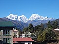
Karyolung From the left: Numbur, Khatang, Karyolung Highest point Elevation 6,511 metres (21,362 ft) Prominence 831 metres (2,726 ft) Coordinates 27°44′00...
3 KB (247 words) - 20:31, 15 March 2023