
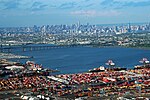
40°38′38″N 74°07′12″W / 40.644°N 74.120°W / 40.644; -74.120 The Kill Van Kull is a tidal strait between Staten Island, New York, and Bayonne, New Jersey...
8 KB (706 words) - 06:59, 26 May 2024
River. Arthur Kill and Kill Van Kull, both separating Staten Island, New York from New Jersey Batten Kill, Vermont and New York Bronx Kill between the Bronx...
3 KB (319 words) - 02:27, 6 November 2023
west lies Kill van Kull, the strait leading to Newark Bay, fed by the Passaic River and Hackensack River, and the northern entrance of Arthur Kill.[citation...
76 KB (7,135 words) - 02:31, 21 August 2024

goods typically arrive on container ships through The Narrows and the Kill Van Kull before entering Newark Bay, a shallow body of water that has been dredged...
16 KB (1,610 words) - 20:23, 13 April 2024

Bayonne is situated on a peninsula between Newark Bay to the west, the Kill Van Kull to the south, and New York Bay to the east. As of the 2020 United States...
173 KB (18,072 words) - 01:02, 16 August 2024
The Bayonne Bridge is an arch bridge that spans the Kill Van Kull between Staten Island, New York and Bayonne, New Jersey. It carries New York State Route 440...
80 KB (7,152 words) - 13:38, 19 August 2024

Stannards Brook Tibbetts Brook Inter-state Arthur Kill Kill Van Kull Long Island Sound New York Bronx Kill Buttermilk Channel East River Grass Hassock Channel...
29 KB (2,054 words) - 02:39, 8 May 2024
Newark Bay is connected to Upper New York Bay by the Kill Van Kull and to Raritan Bay by the Arthur Kill. The names of the channels reflect the period of...
24 KB (2,274 words) - 21:51, 4 August 2024

separated from the adjacent state of New Jersey by the Arthur Kill and the Kill Van Kull and from the rest of New York by New York Bay. With a population...
160 KB (16,766 words) - 02:07, 21 August 2024
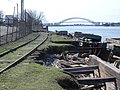
which will run on the North Shore Branch right-of-way, adjacent to the Kill van Kull. $5 million was allocated in the 2015–2019 Capital Program for environmental...
22 KB (2,532 words) - 19:04, 6 March 2024

between it and the Upper New York Bay. The sister channel of Arthur Kill, Kill van Kull, refers to the waterway that flows from the col or ridge or passage...
13 KB (1,228 words) - 16:31, 25 July 2024

and runs for 0.75 miles (1.21 km) along the shore the Kill van Kull. Once known as Kill van Kull Park, it is named for Dennis P. Collins, who served at...
8 KB (691 words) - 20:38, 10 February 2024
City Subway) Jan De Bakkers Kill Kaaterskill Creek Kaaterskill Falls Katsbaan, New York Kaikout Kill Keyser Kill Kill Van Kull Kinderhook (town), New York...
12 KB (1,145 words) - 06:21, 26 July 2024

residential harbor front area along the Kill Van Kull west of St. George. New Brighton is bounded by Kill Van Kull on the north, Jersey Street on the east...
55 KB (6,412 words) - 13:40, 23 May 2024

List of bridges, tunnels, and cuts in Hudson County, New Jersey (section Kill van Kull and Newark Bay)
has extensive waterfront along the Hudson River, Upper New York Bay, Kill van Kull, Newark Bay and the Hackensack and Passaic Rivers. The main part of...
24 KB (542 words) - 12:17, 16 May 2024
tip of Staten Island in New York City, along the waterfront where the Kill Van Kull enters Upper New York Bay. It is the most densely developed neighborhood...
89 KB (9,476 words) - 13:38, 31 July 2024

connected to Lower New York Bay by the Narrows, to Newark Bay by the Kill Van Kull, and to Long Island Sound by the East River, which, despite its name...
35 KB (3,863 words) - 13:48, 16 August 2024
(15.7 km2) and was bounded by Upper New York Bay on the east and the Kill Van Kull on the north. The town dates from the late 17th century. It was originally...
3 KB (241 words) - 00:38, 21 May 2023

Passaic River. The Passaic River drains at Newark Bay and via Arthur Kill and Kill van Kull to the Atlantic Ocean. The northern part of the Saddle River watershed...
4 KB (402 words) - 04:44, 14 April 2024

Staten Island, a borough of New York City. Port Richmond is bounded by Kill van Kull on the north, Clove Road on the east, Forest Avenue on the south, and...
46 KB (5,769 words) - 13:50, 23 May 2024
(near the modern Ballpark Station), the line ran on the shore of the Kill Van Kull from New Brighton to West Brighton. The line ran on land between St...
53 KB (5,322 words) - 22:59, 19 July 2024

States. It is located on Newark Bay near the entrances the Kill van Kull in the east and Arthur Kill in the west. It is bordered by Arlington to the east,...
5 KB (535 words) - 10:57, 12 November 2023

the Claremont, the Port Jersey, the Kill Van Kull, the Newark Bay, the Port Newark, the Elizabeth, and the Arthur Kill. Anchorages are known as Stapleton...
4 KB (378 words) - 14:59, 24 October 2023

Brighton to the east, Port Richmond to the west, the waters of the Kill Van Kull to the north, and the communities of Sunnyside and Castleton Corners...
16 KB (1,700 words) - 01:10, 2 April 2024

navigable channel, the moveable bridge allowed marine traffic from Kill Van Kull to access the Port of Newark. At the turn of the twentieth century,...
17 KB (1,526 words) - 01:38, 28 May 2024

India Company. Their ship, the Halve Maen (Half Moon), ventured in the Kill van Kull and Newark Bay and anchored at Weehawken Cove during 1609, while exploring...
24 KB (2,657 words) - 22:25, 3 May 2024
Col, Achter Kull, Archer Col, Achter Kull. The name Achter Kol is largely extinct, though it is likely to have evolved into Arthur Kill, the name of...
51 KB (4,965 words) - 00:41, 23 May 2024

Constable Hook (section Van Buskirk family)
Constable Hook is a cape located on the north side of the outlet of Kill van Kull into Upper New York Bay in Bayonne, New Jersey. The cape has long been...
11 KB (1,358 words) - 13:20, 6 September 2023
Hassock (Jamaica Bay) Isle of Meadows (Arthur Kill) Prall's Island (Arthur Kill) Shooters Island (Kill van Kull), shared with New Jersey Hoffman Island (Lower...
4 KB (296 words) - 14:33, 3 February 2024

U.S. state of New Jersey. The point is located on the north side of Kill van Kull at Newark Bay. It is the section of the city closest to the Bayonne...
8 KB (604 words) - 00:13, 24 July 2023