
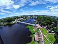
Kishoreganj District (Bengali: কিশোরগঞ্জ জেলা) is a district in Dhaka Division, Bangladesh. Earlier it was a mahakuma (sub-division) under Mymensingh...
29 KB (2,994 words) - 13:17, 23 March 2025
Population and Housing Census 2011 Zila Report – Kishoreganj" (PDF). Bangladesh Bureau of Statistics. "Community Tables: Kishoreganj district" (PDF). Bangladesh...
5 KB (158 words) - 17:36, 16 March 2025

Census 2011 Zila Report – Kishoreganj" (PDF). Bangladesh Bureau of Statistics. Population and Housing Census 2022 - District Report: Kishoreganj (PDF). District...
7 KB (548 words) - 19:09, 2 April 2025

Kishoreganj (Bengali: কিশোরগঞ্জ) is an upazila of Nilphamari District in the Division of Rangpur, Bangladesh. The upazila was named after Prince Kishore...
7 KB (493 words) - 19:04, 14 December 2024

Katiadi Upazila (category Kishoreganj District)
ISBN 978-984-475-263-4. "Bangladesh Population and Housing Census 2011 Zila Report – Kishoreganj" (PDF). Bangladesh Bureau of Statistics. Archived (PDF) from the...
7 KB (483 words) - 17:53, 15 April 2025

into districts or zilas (Bengali: জেলা). The headquarters of a district is called the district seat (Bengali: জেলা সদর, romanized: zila sadar). There are...
24 KB (1,542 words) - 10:06, 4 April 2025

Narsingdi District (redirect from Narsingdi zila)
district is famous for its textile craft industry. Narsingdi is bordered by Kishoreganj in the north and north-east, Brahmanbaria in the east and south-east...
11 KB (784 words) - 17:35, 14 April 2025
Bhairab Upazila (category Upazilas of Kishoreganj District)
Housing Census 2011 Zila Report – Kishoreganj" (PDF). bbs.gov.bd. Bangladesh Bureau of Statistics. "Community Tables: Kishoreganj district" (PDF). bbs...
11 KB (945 words) - 18:18, 10 February 2025

Itna Upazila (category Upazilas of Kishoreganj District)
Housing Census 2011 Zila Report – Kishoreganj" (PDF). bbs.gov.bd. Bangladesh Bureau of Statistics. "Community Tables: Kishoreganj district" (PDF). bbs...
10 KB (921 words) - 15:32, 23 October 2024

Austagram Upazila (category Upazilas of Kishoreganj District)
Housing Census 2011 Zila Report – Kishoreganj" (PDF). bbs.gov.bd. Bangladesh Bureau of Statistics. "Community Tables: Kishoreganj district" (PDF). bbs...
6 KB (368 words) - 15:31, 23 October 2024

Kuliarchar Upazila (category Upazilas of Kishoreganj District)
Housing Census 2011 Zila Report – Kishoreganj" (PDF). bbs.gov.bd. Bangladesh Bureau of Statistics. "Community Tables: Kishoreganj district" (PDF). bbs...
7 KB (405 words) - 15:30, 23 October 2024

Mymensingh District (redirect from Mymensingh zila)
south by Gazipur District, in the east by the districts of Netrokona and Kishoreganj, and in the west by the districts of Sherpur, Jamalpur and Tangail. Mymensingh...
29 KB (2,655 words) - 19:50, 31 March 2025

Nikli Upazila (category Upazilas of Kishoreganj District)
Housing Census 2011 Zila Report – Kishoreganj" (PDF). bbs.gov.bd. Bangladesh Bureau of Statistics. "Community Tables: Kishoreganj district" (PDF). bbs...
5 KB (348 words) - 15:33, 23 October 2024

Brahmanbaria District (redirect from Brahmanbaria zila)
topographically part of the Gangetic Plain. It is bounded by the districts of Kishoreganj and Habiganj to the north, Narsingdi District and Narayanganj to the...
25 KB (1,865 words) - 14:59, 17 March 2025

Mirganj Union Shaulmari Union Simulbari Union Kishoreganj Thana, now an upazila, was formed in 1921. Kishoreganj was part of Dimla thana of Nilphamari Mohokuma...
5 KB (501 words) - 10:29, 29 March 2025

Netrokona District (redirect from Netrakona zila)
Hills in Meghalaya, India in the north, Sunamganj District in the east, Kishoreganj District in the south and Mymensingh District in the west. Netrokona...
16 KB (1,415 words) - 19:37, 31 March 2025

Tarail Upazila (category Upazilas of Kishoreganj District)
Housing Census 2011 Zila Report – Kishoreganj" (PDF). bbs.gov.bd. Bangladesh Bureau of Statistics. "Community Tables: Kishoreganj district" (PDF). bbs...
6 KB (368 words) - 15:32, 23 October 2024

Bajitpur Upazila (category Upazilas of Kishoreganj District)
Bajitpur is an upazila of Kishoreganj District in Bangladesh. Bajitpur was created by Baizid Kha. Formerly Bhairab and Kuliarchar were included in this...
12 KB (1,198 words) - 05:40, 5 December 2024
Netrokona Sadar and Atpara upazilas on the north, Tarail Upazila of Kishoreganj district on the south, Madan upazila on the east, Ishwarganj, Gauripur...
8 KB (507 words) - 12:18, 19 April 2025

Dimla, western part by Nilphamari Sadar Upazila and southern part by Kishoreganj Upazila. According to the 2011 Census of Bangladesh, Jaldhaka Upazila...
6 KB (453 words) - 12:39, 23 October 2024

Hossainpur Upazila (category Upazilas of Kishoreganj District)
Housing Census 2011 Zila Report – Kishoreganj" (PDF). bbs.gov.bd. Bangladesh Bureau of Statistics. "Community Tables: Kishoreganj district" (PDF). bbs...
12 KB (1,190 words) - 20:46, 23 February 2025

Nilphamari District (redirect from Nilphamari zila)
Maynamotir Garh Chilahati Land Port Parallel Watering System Bahagili Bridge Kishoreganj Nilsagar a famous historical dighi (big pond) that stands at Dhobadanga...
20 KB (1,740 words) - 14:58, 23 March 2025

Tangail District (redirect from Tangail zila)
District (Bengali: টাঙ্গাইল জেলা, romanized: Ṭāṅgāil Jēlā) is a district (zila) in the central region of Bangladesh. In 1969, Tangail mahakuma was separated...
24 KB (1,951 words) - 06:22, 6 April 2025

the north, Nandail in the east, Hossainpur and Pakundia upazilas of Kishoreganj district, Kapasia and Sreepur upazilas of Gazipur district on the south...
9 KB (655 words) - 16:38, 12 April 2025

lies the Aditmari Upazila of Lalmonirhat District and to its west is Kishoreganj Upazila of Nilphamari District. Like much of the Rangpur region, Gangachara...
13 KB (1,337 words) - 11:04, 20 January 2025
is bounded by Debiganj and Domar upazilas on the north, Jaldhaka and Kishoreganj upazilas on the east, Saidpur Upazila to the south and Khansama Upazila...
7 KB (502 words) - 12:38, 23 October 2024

8917°E / 25.7778; 88.8917. The upazila is bounded by Nilphamari Sadar and Kishoreganj upazilas on the north-east, Badarganj and Parbatipur upazilas on the...
8 KB (550 words) - 15:18, 14 March 2025

Population and Housing Census 2011 Zila Report – Kishoreganj" (PDF). Bangladesh Bureau of Statistics. "Community Tables: Kishoreganj district" (PDF). Bangladesh...
12 KB (1,068 words) - 11:26, 16 February 2025

Karimganj Upazila (category Upazilas of Kishoreganj District)
Housing Census 2011 Zila Report – Kishoreganj" (PDF). bbs.gov.bd. Bangladesh Bureau of Statistics. "Community Tables: Kishoreganj district" (PDF). bbs...
10 KB (936 words) - 15:32, 23 October 2024

Mithamain Upazila (category Upazilas of Kishoreganj District)
Population and Housing Census 2011 Zila Report – Kishoreganj" (PDF). Bangladesh Bureau of Statistics. "Community Tables: Kishoreganj district" (PDF). Bangladesh...
8 KB (662 words) - 13:23, 23 March 2025