non-Aboriginal identity, 345 Aboriginal identity) — Osoyoos Indian Band, Okanagan people, Osoyoos Cumberland House Cree Nation 20, Saskatchewan: 595 Sucker...
22 KB (1,951 words) - 18:48, 26 June 2024
Alberta, Canada; and Montana, US Frozen Lake Lake Koocanusa Alden Lake Osoyoos Lake Ross Lake in Washington, US, and British Columbia, Canada Turtle Lake...
44 KB (1,615 words) - 11:03, 5 September 2024
Memphremagog in Quebec and Vermont Lake Ontario in Ontario and New York Osoyoos Lake in British Columbia and Washington Rainy Lake in Ontario and Minnesota...
40 KB (864 words) - 14:59, 13 June 2024
Nitinat Lake Nuttlude Lake Lake O'Hara Lake Oesa Okanagan Lake Opabin Lake Osoyoos Lake Oshinow Lake Otter Lake, British Columbia Owikeno Lake Paterson Lake...
11 KB (837 words) - 21:29, 31 July 2024
length of British Columbia, connecting the Canada–United States border near Osoyoos in the south to the British Columbia–Yukon boundary in the north at Watson...
32 KB (1,683 words) - 15:54, 25 July 2024

The results Regional District of Okanagan-Similkameen Electoral Area A (Osoyoos Rural) were as follows: The results Regional District of Okanagan-Similkameen...
109 KB (1,724 words) - 18:41, 25 August 2024
province. The Crowsnest Highway (Highway 3) runs from Hope, then through Osoyoos, Castlegar, Cranbrook, right to Crowsnest Pass on the BC/Alberta border...
94 KB (1,333 words) - 10:43, 20 August 2024
Falls – Okanagan Falls Review 100 Mile House – 100 Mile House Free Press Osoyoos – Times Chronicle, Desert Connections Parksville/Qualicum Beach – The Morning...
49 KB (2,643 words) - 17:23, 13 October 2024

British Columbia/ Montana Lake of the Woods Ontario / Manitoba/ Minnesota Osoyoos Lake British Columbia/ Washington Rainy Lake Minnesota/ Ontario Ross...
10 KB (26 words) - 07:43, 23 July 2024
Okanagan Falls 1T0: Oliver 1V0: Osoyoos 1X0: Peachland 1Y0: Rock Creek 1Z0: Summerland 2B0: Westbridge 2V0: Osoyoos 3H0: Grand Forks V0J Bulkley Valley...
56 KB (220 words) - 17:15, 3 October 2024
119°40′15.74″W / 49.0002111°N 119.6710389°W / 49.0002111; -119.6710389 Osoyoos Highway 97 Oroville ORO US 97 Year-round (24-hour service) 49°0′0.36″N...
115 KB (1,288 words) - 11:47, 9 October 2024

Canada. However, it and the neighbouring Columbia Plateau ecoregion near Osoyoos are semi-arid ecoregions and are not true deserts. Vegetative cover in...
9 KB (814 words) - 05:04, 9 February 2024
then subsequently through various smaller lakes, including Namakan Lake, Lac la Croix, and Sea Gull Lake. The border then crosses the Height of Land Portage...
82 KB (8,891 words) - 19:38, 15 October 2024
School District 53 Okanagan Similkameen Oliver Okanagan/Mainline Oliver, Osoyoos, Okanagan Falls, Keremeos School District 54 Bulkley Valley Smithers Northwest...
16 KB (218 words) - 18:28, 7 June 2024
Mountains, Omineca Country Ominicetla River Ootsa Lake Opitsaht Osilinka River Osoyoos: From suius in the Okanagan language, meaning "Narrowing of the waters";...
91 KB (10,413 words) - 21:35, 31 August 2024
22 (21). Archived from the original (PDF) on March 4, 2016. "Route 40 Osoyoos/Penticton". www.bctransit.com. "Route 50 Penticton/Princeton". www.bctransit...
21 KB (1,894 words) - 03:20, 10 September 2023
Exit 336 provides an important turnoff to Logan Lake on Highway 97D and Lac le Jeune. Shortly after the junction, the highway descends into the city...
37 KB (2,910 words) - 15:54, 25 July 2024
CBCY-TV-3 4 Moyie CBC CBUBT-14 6 Nelson CBC CBUCT 9 New Denver CBC CBUCT-6 17 Osoyoos CBC CBUT-42 6 Pemberton CBC CBUPT 4 Penticton CBC CBUT-40 17 Phoenix CBC...
19 KB (3,567 words) - 00:00, 20 July 2024
1985. ^a . This station was initially called Delmar. The Dewdney Trail to Osoyoos passed through the area. A wagon road later followed the east shore of...
30 KB (2,238 words) - 20:17, 9 May 2024

Oliver with Penticton. (In 1944, the Osoyoos Subdivision was extended another 10 miles to connect Oliver with Osoyoos.) In the late 1930s until into the...
21 KB (2,983 words) - 22:28, 19 May 2024

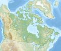
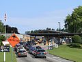
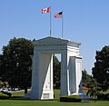
in British Columbia, Canada, located on the west side of Osoyoos Lake in the town of Osoyoos, which is on the Canada-United States border at the southern...
7 KB (576 words) - 05:05, 14 September 2022
Jun 1961. p. A1. "Merritt Herald". arch.tnrl.ca. 13 Sep 1961. p. A14. "Osoyoos Times". www.timeschronicle.ca. 27 Feb 2018. "Creston Valley Advance". www...
62 KB (3,714 words) - 20:30, 28 September 2024

2016-03-03. "Klua Lakes Protected Area". BC Parks. Retrieved 2016-03-03. "Lac du Bois Grasslands Protected Area". BC Parks. Retrieved 2016-03-04. "Lower...
234 KB (615 words) - 16:50, 23 July 2024
Nk'mip Desert Cultural Centre Osoyoos Okanagan-Similkameen Natural history of the Okanagan Desert and culture of the Osoyoos Indian Band North Island Wildlife...
22 KB (42 words) - 13:40, 15 August 2024
North Vancouver (city) ? 2014 Oliver Chronicle BC Oliver ? 2020 Osoyoos Times BC Osoyoos 1947 2020 Oceanside Star BC Parksville ? 2015 Penticton Western...
78 KB (43 words) - 22:00, 16 September 2024
Squamish) East Kelowna (within the City of Kelowna) East Osoyoos (within the Town of Osoyoos) East Sooke East Trail East Wellington Eastburn (within the...
110 KB (5,935 words) - 10:07, 24 December 2023
Municipal elections were held in the Canadian province of British Columbia on October 20, 2018. Races were held in all municipalities and regional district...
97 KB (518 words) - 18:29, 25 August 2024

Canadian populations above the national average. Rural region surrounding Osoyoos. Rural region surrounding Oliver. Rural region including Clearwater, Vavenby...
193 KB (12,388 words) - 21:21, 2 October 2024
territories". Indigenous leaders, including Chief Clarence Louie of the Osoyoos Indian Band, as well as the prime minister and provincial officials condemned...
127 KB (12,042 words) - 13:57, 15 October 2024
105.86 170 Highway 3 east (Crowsnest Highway) – Princeton, Penticton, Osoyoos Highway 5 north (Coquihalla Highway) – Merritt, Kelowna, Kamloops Hwy 1...
71 KB (3,894 words) - 02:36, 14 September 2024