
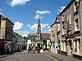
Leigh-on-Mendip or Leigh upon Mendip (on Ordnance Survey maps) is a small village on the Mendip Hills in Somerset, England. It lies roughly equidistant...
9 KB (825 words) - 11:14, 11 August 2024
Worcestershire Leigh-on-Mendip, Somerset (also known as Leigh upon Mendip) Leigh Delamere, Wiltshire Leigh Green, Kent Leigh Park, Hampshire Leigh Sinton, Worcestershire...
2 KB (213 words) - 22:59, 26 September 2023

The Mendip Hills (commonly called the Mendips) is a range of limestone hills to the south of Bristol and Bath in Somerset, England. Running from Weston-super-Mare...
68 KB (6,696 words) - 04:06, 23 August 2024
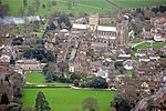
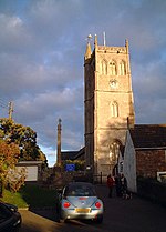
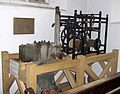
The Church of St Giles in Leigh-on-Mendip, Somerset, England, dates from around 1350, and was rebuilt around 1500. It is a Grade 1 listed building, with...
3 KB (289 words) - 00:06, 9 December 2023

Hornblotton – Horrington – Huxham Green Kilmersdon Lamyatt – Leigh-on-Mendip – Leighton – Litton – Lydford-on-Fosse Maesbury – Meare – Mells Nettlebridge – North...
74 KB (2,290 words) - 21:55, 21 December 2023
Langford Budville, Langport, Langridge, Laverton, Leighland Chapel, Leigh-on-Mendip, Lilstock, Limington, Littleton, Litton, Locking, Long Ashton, Long...
18 KB (1,121 words) - 09:09, 21 October 2021
Langford Budville CE Primary School, Langford Budville Leigh-on-Mendip School, Leigh-on-Mendip Long Sutton CE Primary School, Long Sutton Lovington CE...
19 KB (1,762 words) - 16:09, 22 August 2024
Axbridge (category Mendip Hills)
Axbridge is a town in Somerset, England, on the River Axe, near the southern edge of the Mendip Hills. Its population according to the 2011 census was...
17 KB (1,832 words) - 17:30, 11 August 2024

Bristol on the A39 very close to the A37. The village is in a valley on the Mendip Hills, is the source of the River Chew and is therefore on the edge...
21 KB (2,717 words) - 21:13, 26 September 2024
List of civil parishes in Somerset (section Mendip)
Retrieved 1 January 2014. "Leigh-on-Mendip Parish". Neighbourhood Statistics. Office for National Statistics. Archived from the original on 2 January 2014. Retrieved...
229 KB (4,312 words) - 02:08, 9 September 2024

The caves of the Mendip Hills are formed by the particular geology of the Mendip Hills: large areas of limestone worn away by water makes it a national...
16 KB (1,100 words) - 22:27, 23 August 2024
Wells, Somerset (category Towns in Mendip District)
is a cathedral city and civil parish in Somerset, located on the southern edge of the Mendip Hills, 21 miles (34 km) south-east of Weston-super-Mare, 22 mi...
81 KB (7,827 words) - 14:52, 5 October 2024
Cheddar, Somerset (category Mendip Hills)
parish in the English county of Somerset. It is situated on the southern edge of the Mendip Hills, 9 miles (14 km) north-west of Wells, 11 miles (18 km)...
64 KB (6,046 words) - 17:02, 4 October 2024
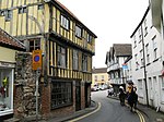
Shepton Mallet (category Towns in Mendip District)
It had an estimated population of 10,810 in 2019. Mendip District Council was based there. The Mendip Hills lie to the north and the River Sheppey runs...
101 KB (10,734 words) - 14:22, 21 September 2024

Gough's Cave (category Caves of the Mendip Hills)
Gough's Cave (/ɡɒf/ GOF) is located in Cheddar Gorge on the Mendip Hills, in Cheddar, Somerset, England. The cave is 115 m (377 ft) deep and is 3.405 km...
17 KB (1,804 words) - 23:56, 6 September 2023

Winscombe (category Mendip Hills)
England, close to the settlements of Axbridge and Cheddar, on the western edge of the Mendip Hills, 7 miles (11 km) southeast of Weston-super-Mare and...
10 KB (1,045 words) - 22:03, 25 September 2024

Cheddar Gorge (category Mendip Hills)
Cheddar Gorge Cheddar Gorge is a limestone gorge in the Mendip Hills, near the village of Cheddar, Somerset, England. The gorge is the site of the Cheddar...
33 KB (3,168 words) - 21:12, 26 September 2024

Wookey Hole Caves (category Caves of the Mendip Hills)
cave and tourist attraction in the village of Wookey Hole on the southern edge of the Mendip Hills near Wells in Somerset, England. The River Axe flows...
55 KB (6,575 words) - 04:18, 16 August 2024
Swildon's Hole (category Caves of the Mendip Hills)
Somerset. At 9,144 metres (30,000 ft) in length, it is the longest cave on the Mendip Hills. It has been found to be connected to Priddy Green Sink and forms...
8 KB (847 words) - 11:51, 23 August 2023
Black Down, Somerset (category Mendip Hills)
Black Down is the highest hill in the Mendip Hills, Somerset, in south-western England. Black Down lies just a few miles eastward of the Bristol Channel...
10 KB (1,088 words) - 00:43, 12 April 2024
The Mendip Way is an 80-kilometre (50 mi) long-distance footpath across the Mendip Hills from Weston-super-Mare to Frome. It is divided into two sections...
11 KB (1,221 words) - 19:02, 4 September 2021

Shambles, Shepton Mallet (category Grade II listed buildings in Mendip District)
series Day Out, in an episode entitled "The Southern Edge of Mendip", and broadcast on BBC Two. It was also filmed for the television documentary series...
55 KB (4,804 words) - 14:12, 2 October 2024

Pen Hill (category Mendip Hills)
Hill forms part of the Mendip Hills plateau in Somerset, England. The hill is located in St Cuthbert Out civil parish in Mendip district. The name Pen...
3 KB (285 words) - 15:24, 28 February 2024

Sandford, Somerset (category Coordinates on Wikidata)
between Churchill and Banwell on the A368 in North Somerset, England. The Parish of Winscombe and Sandford, centred on the Parish Church of Saint James...
2 KB (208 words) - 06:41, 25 July 2024
Bleadon (category Mendip Hills)
the Somerset Archaeological and Natural History Society. 154: 119–164. "Mendip Hills An Archaeological Survey of the Area of Outstanding Natural Beauty"...
11 KB (1,137 words) - 17:31, 15 July 2023

River Chew (category Mendip Hills)
Mendip. Strode Brook and Winford Brook are the main tributaries, both joining the Chew from the left. The river flows northwest from Chewton Mendip through...
9 KB (690 words) - 18:43, 8 May 2024

The Mendip Hills, (Mendips) in northern Somerset, are the most southerly Carboniferous Limestone uplands in Britain. The Mendips comprise three major anticlinal...
4 KB (273 words) - 18:13, 3 February 2023
Hillingdon, London St Giles' Church, Imber, Wiltshire Church of St Giles, Leigh-on-Mendip, Somerset St Giles Church, Lincoln, Lincolnshire St Giles' Church,...
4 KB (483 words) - 17:54, 2 September 2024
Cullompton St John the Baptist Parish Church, Glastonbury St Giles' Church, Leigh-on-Mendip Church of St John the Baptist, Lustleigh Parish Church of Marwood,...
14 KB (1,271 words) - 11:04, 14 April 2024
Torr Works (category Quarries in the Mendip Hills)
Mallet on the Mendip Hills, Somerset, England. The quarry was formerly known as Merehead, a name which has been retained for its rail depot on the opposite...
3 KB (345 words) - 12:30, 12 July 2024