This is a list of listed buildings in the parish of Greenlaw in the Scottish Borders, Scotland. Map all coordinates using OpenStreetMap Download coordinates...
2 KB (273 words) - 22:54, 4 October 2022
listed buildings in Gordon, Scottish Borders List of listed buildings in Greenlaw, Scottish Borders List of listed buildings in Hawick, Scottish Borders List...
6 KB (728 words) - 17:05, 10 April 2022
A6105 in the Scottish Borders area of Scotland. At the 2001 census, the parish had a population of 661. Greenlaw was first made the county town of Berwickshire...
17 KB (1,495 words) - 04:00, 21 June 2024
town in the Scottish Borders, Scotland. It was the county town of the historic county of Berwickshire. Duns Law, the original site of the town of Duns...
25 KB (3,212 words) - 05:56, 19 May 2024
Prior of Fogo List of places in the Scottish Borders List of places in Scotland Historic Environment Scotland. "Fogo Bridge (Category A Listed Building) (LB10513)"...
3 KB (211 words) - 05:54, 19 May 2024

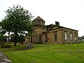
Greenlaw Town Hall is a municipal building in The Square, Greenlaw, Scottish Borders, Scotland. The structure, which served as the county headquarters...
11 KB (1,238 words) - 10:14, 28 November 2023
This is a list of listed buildings in the parish of Duns in the Scottish Borders, Scotland. Map all coordinates using OpenStreetMap Download coordinates...
36 KB (273 words) - 18:55, 11 September 2023
This is a list of listed buildings in the parish of Kelso in the Scottish Borders, Scotland. Map all coordinates using OpenStreetMap Download coordinates...
31 KB (273 words) - 18:36, 6 June 2023
This is a list of listed buildings in the parish of Selkirk in the Scottish Borders, Scotland. Map all coordinates using OpenStreetMap Download coordinates...
24 KB (273 words) - 18:51, 25 February 2024

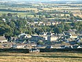
Preston is a small village in the ancient county of Berwickshire, now an administrative area of the Scottish Borders region of Scotland. It lies within the local...
6 KB (658 words) - 00:56, 19 May 2024
This is a list of listed buildings in the parish of Melrose in the Scottish Borders, Scotland. Map all coordinates using OpenStreetMap Download coordinates...
25 KB (273 words) - 11:43, 12 May 2024

Berwickshire (redirect from Berwickshire, Borders)
to Greenlaw. Commissioners of Supply were established for each Scottish shire in 1667. County Hall was built at Greenlaw in 1829 to serve as the courthouse...
22 KB (2,035 words) - 17:29, 23 April 2024
This is a list of listed buildings in the parish of Stow in the Scottish Borders, Scotland. Map all coordinates using OpenStreetMap Download coordinates...
5 KB (273 words) - 22:39, 5 October 2022

This is a list of Category A listed buildings in the Scottish Borders council area in south-east Scotland. In Scotland, the term listed building refers to...
78 KB (2,088 words) - 19:26, 7 May 2024
This is a list of listed buildings in the parish of Linton in the Scottish Borders, Scotland. Map all coordinates using OpenStreetMap Download coordinates...
9 KB (273 words) - 14:08, 10 April 2022
is a list of castles in the Scottish Borders. Castles in Scotland List of castles in Scotland List of listed buildings in the Scottish Borders Hawick...
7 KB (85 words) - 22:50, 7 September 2022
This is a list of listed buildings in the parish of Whitsome in the Scottish Borders, Scotland. Map all coordinates using OpenStreetMap Download coordinates...
4 KB (273 words) - 17:05, 10 April 2022
This is a list of listed buildings in the parish of Innerleithen in the Scottish Borders, Scotland. Map all coordinates using OpenStreetMap Download coordinates...
11 KB (273 words) - 06:26, 7 March 2022
This is a list of listed buildings in the parish of Caddonfoot in the Scottish Borders, Scotland. Map all coordinates using OpenStreetMap Download coordinates...
3 KB (273 words) - 12:56, 10 April 2022
This is a list of listed buildings in the parish of Galashiels in the Scottish Borders, Scotland. Map all coordinates using OpenStreetMap Download coordinates...
20 KB (273 words) - 01:23, 5 January 2024
This is a list of listed buildings in the parish of Lilliesleaf in the Scottish Borders, Scotland. Map all coordinates using OpenStreetMap Download coordinates...
4 KB (273 words) - 11:31, 2 September 2023
This is a list of listed buildings in the parish of Hutton in the Scottish Borders, Scotland. Map all coordinates using OpenStreetMap Download coordinates...
10 KB (273 words) - 08:29, 26 June 2023
This is a list of listed buildings in the parish of Yarrow in the Scottish Borders, Scotland. Map all coordinates using OpenStreetMap Download coordinates...
3 KB (273 words) - 17:05, 10 April 2022
This is a list of listed buildings in the parish of Peebles in the Scottish Borders, Scotland. Map all coordinates using OpenStreetMap Download coordinates...
28 KB (273 words) - 06:39, 7 March 2022
This is a list of listed buildings in the parish of Yetholm in the Scottish Borders, Scotland. Map all coordinates using OpenStreetMap Download coordinates...
18 KB (273 words) - 17:05, 10 April 2022
This is a list of listed buildings in the parish of Ayton in the Scottish Borders, Scotland. Map all coordinates using OpenStreetMap Download coordinates...
11 KB (273 words) - 11:11, 10 April 2022
This is a list of listed buildings in the parish of Longformacus in the Scottish Borders, Scotland. Map all coordinates using OpenStreetMap Download coordinates...
6 KB (273 words) - 18:50, 25 February 2024
This is a list of listed buildings in the parish of Chirnside in the Scottish Borders, Scotland. Map all coordinates using OpenStreetMap Download coordinates...
7 KB (273 words) - 12:57, 10 April 2022
This is a list of listed buildings in the parish of Castleton in the Scottish Borders, Scotland. Map all coordinates using OpenStreetMap Download coordinates...
3 KB (273 words) - 12:57, 10 April 2022
This is a list of listed buildings in the parish of Earlston in the Scottish Borders, Scotland. Map all coordinates using OpenStreetMap Download coordinates...
3 KB (273 words) - 06:18, 7 March 2022