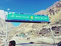
Mana is a village in the district of Chamoli in the Indian state of Uttarakhand, located at an altitude of 3,200 meters {10,500 feet}. It is located on...
5 KB (317 words) - 05:54, 24 July 2024

Chamoli district is a district of the Uttarakhand state of India. It is bounded by the Tibet region to the north, and by the Uttarakhand districts of...
43 KB (5,711 words) - 17:12, 31 May 2024

connects Dehradun, Rishikesh, Devaprayag, Rudraprayag, Karnaprayag, Chamoli, Badrinath, Mana at Indo/Tibet border in the state of Uttarakhand. Punjab NH 62...
6 KB (440 words) - 21:52, 17 October 2024
tehsil, Chamoli District, Garhwal Division, Uttarakhand (in Niti, Gamshali, Bampa, and Malari villages) Mana valley, Joshimath tehsil Chamoli District...
1 KB (89 words) - 21:45, 15 December 2021

Badrinath (category Cities and towns in Chamoli district)
Dwarka Jagannath Puri Rameswaram Badrinath is a town and nagar panchayat in Chamoli district in the state of Uttarakhand, India. It is a Hindu holy place,...
15 KB (1,258 words) - 05:43, 26 September 2024

The temple to him is located on the banks of the Alaknanda River in the Chamoli district of Uttrakhand. The second dhāma, Rameswaram, has its origins in...
15 KB (1,469 words) - 15:55, 18 October 2024

Vasudhara Falls (category Geography of Chamoli district)
with special reference to mountaineering and trekking in Uttarkashi and Chamoli Districts. New Delhi: Indus Pub. Co. pp. 41, 43. ISBN 9788173870064. Wikimedia...
4 KB (499 words) - 05:31, 7 March 2023

Earlier it was built only up to Chamoli and has over the years gradually been extended to Joshimath, Badrinath and finally to Mana Pass near the border with...
9 KB (922 words) - 21:52, 17 October 2024
Pithoragarh, Chamoli and Uttarkashi. The seven major Bhotiya groups in Uttarakhand are the Johari, Darmiya, Chaudansi, Byansi, Marchha (Mana Valley), Tolchha...
20 KB (929 words) - 05:53, 12 September 2024

Devi Abi Gamin Mana Peak Mukut Parbat The cities which are included in these ranges are Pauri, Tehri, Uttarkashi, Rudraprayag, Chamoli, and Chota Char...
2 KB (205 words) - 23:00, 27 August 2024
Nandaprayag (category Cities and towns in Chamoli district)
Nandaprayag is a town and a nagar panchayat in Chamoli district in the Indian state of Uttarakhand. Nandaprayag is one of the Panch Prayag (five confluences)...
6 KB (441 words) - 01:32, 8 September 2024

approached from Joshimath in the Chamoli sub-division, by following the Badrinath and Mana (3128 m above sea level) road. From Mana, the route follows the course...
4 KB (367 words) - 03:03, 12 May 2024
Karnaprayag (category Cities and towns in Chamoli district)
Karnaprayag is a town and municipal board in the Chamoli District in the Indian state of Uttarakhand. Karnaprayag is one of the Panch Prayag (five confluences)...
8 KB (603 words) - 23:23, 3 December 2023

the Rishiganga on its left bank at Rini, in the vicinity of Tapovan in Chamoli district. It then flows 20 km (10 mi) westwards until it meets the Alaknanda...
4 KB (413 words) - 21:29, 16 April 2024

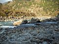
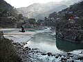
Alaknanda River (category Geography of Chamoli district)
of the Ganges than the Bhagirathi. The Alaknanda system drains parts of Chamoli, Tehri, and Pauri districts. The Alaknanda is of special interest to the...
12 KB (904 words) - 02:45, 31 January 2024

Joshimath (category Cities and towns in Chamoli district)
Joshimath, also known as Jyotirmath, is a town and a municipal board in Chamoli District in the Indian state of Uttarakhand. Located at a height of 6,150...
21 KB (1,944 words) - 01:01, 24 August 2024

Kamet (category Geography of Chamoli district)
Nanda Devi. It is the 29th highest mountain in the world. It lies in the Chamoli District of Uttarakhand. Its appearance resembles a giant pyramid topped...
14 KB (1,855 words) - 13:31, 1 July 2024
Kamet Mana Peak Garhwal Chamoli 30°52′50″N 79°36′55″E / 30.88056°N 79.61528°E / 30.88056; 79.61528 7,272 23,858 Kamet Mukut Parbat Garhwal Chamoli 30°56′57″N...
47 KB (306 words) - 12:38, 8 June 2024
Abi Gamin (category Geography of Chamoli district)
back successfully. Mukut Parbat, Kamet and Mana. All three peaks are linked by a ridge. Joshimath (Chamoli)--Markari-Nitti-Sapukaharak-Nand-Kharak-BC-CI-CII-CIII...
7 KB (797 words) - 12:08, 10 October 2024
Mana Parbat II (Hindi: माना पर्वत II) is a mountain of the Garhwal Himalaya in Uttarakhand, India. Mana Parbat II standing majestically at 6,771 metres...
4 KB (444 words) - 13:02, 20 June 2022
Rudranath (category Chamoli district)
of India" (Govt. of India). National Informatics Centre, District Uni Chamoli, Uttarakhand. Archived from the original on 25 December 2008. Retrieved...
13 KB (1,368 words) - 15:13, 26 August 2024

Saraswati River (Uttarakhand) (category Geography of Chamoli district)
Uttarakhand State, India. It joins Alaknanda River at Keshav Prayag, near Mana village, Badrinath. The confluence of rivers Alaknanda and Bhagirathi at...
3 KB (220 words) - 23:49, 6 June 2024
Mana Parbat I (Hindi: माना पर्वत I) is a mountain of the Garhwal Himalaya in Uttarakhand, India. Mana Parbat I stands at 6,794 metres (22,290 ft). It...
3 KB (306 words) - 19:56, 30 September 2024
is a national park situated around the peak of Nanda Devi (7816 m) in Chamoli Garhwal district of Uttarakhand, in northern India. The entire park lies...
13 KB (1,463 words) - 08:14, 16 September 2024
Saraswati Parbat II (category Geography of Chamoli district)
With Special Reference to Mountaineering and Trekking in Uttarkashi and Chamoli Districts. Indus Publishing. pp. 38–. ISBN 978-81-7387-006-4. "Devprayag...
4 KB (405 words) - 07:43, 7 April 2022
Shiva, who used to reside there with his consort Parvati. It is Located in Chamoli District of Uttarakhand. Lord Vishnu happened to like the place and wished...
32 KB (4,040 words) - 18:35, 6 October 2024

Devprayag lies on national highway NH58 that connects Delhi with Badrinath and Mana Pass in Uttarakhand near Indo-Tibet border. Therefore, all the buses and...
7 KB (718 words) - 21:33, 29 August 2024

K. Samant, Kalpana Chauhan, Maya Upadhyaya, Anuradha Nirala and Deepak Chamoli. All the famous songs and albums from Uttarakhand include Fauji Lalit Mohan...
10 KB (1,302 words) - 12:52, 9 August 2024
Mana Parbat III (Hindi: माना पर्वत III) is a mountain of the Garhwal Himalaya in Uttarakhand, India. Mana Parbat III standing majestically at 6,730 metres...
3 KB (360 words) - 13:21, 12 December 2021

Kalindi (mountain) (category Geography of Chamoli district)
Avalanche Peak (India) 6,196 metres (20,328 ft) its nearest higher neighbor. Mana Parbat II 6,771 metres (22,215 ft) lies 4.2 km NNW and it is 6.1 km NNE of...
4 KB (411 words) - 13:08, 25 March 2023