
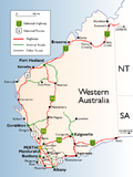
Marmion Avenue is a 40-kilometre (25 mi) arterial road in the northern coastal suburbs of Perth, Western Australia, linking Trigg in the south with Yanchep...
27 KB (1,910 words) - 05:52, 9 August 2024

television series Stormworld. Mindarie is formally bounded by Quinns Road, Marmion Avenue and the Indian Ocean. The suburbs of Clarkson and Merriwa lie to the...
32 KB (3,335 words) - 03:53, 2 September 2024
services terminate on Damper Avenue near Koorana Road, Mullaloo Selected Route 462 services terminate on Marmion Avenue near Gunter Grove, Beldon Selected...
146 KB (9,637 words) - 10:56, 28 August 2024

Eglinton Station to Alkimos Station – serves Marmion Avenue and Heath Avenue Bus routes serving Marmion Avenue: 492 Eglinton Station to Alkimos Station...
10 KB (1,043 words) - 14:18, 26 August 2024

western part between Marmion Avenue and the coast, which is a minor residential distributor road and is discontinuous at Marmion Avenue. Beach Road also serves...
7 KB (714 words) - 12:26, 22 January 2024
kilometres (9 mi) north of Perth's central business district (CBD) between Marmion Avenue and Mitchell Freeway. Its local government area is the City of Stirling...
8 KB (1,035 words) - 08:32, 26 April 2024

– serves Benenden Avenue 491 Alkimos Station to Eglinton Station – serves Marmion Avenue, Shorehaven Boulevard and Heath Avenue 492 Alkimos Station...
8 KB (900 words) - 14:11, 26 August 2024

Clarkson is bounded to the west by Mindarie (Marmion Avenue) and to the north by Merriwa and Ridgewood (Hester Avenue). The Yanchep line divides Clarkson from...
24 KB (2,241 words) - 09:17, 11 September 2024

Satterley. Butler is bordered to the west by Jindalee and Quinns Rocks (Marmion Avenue), to the south by Merriwa and Ridgewood (Lukin Drive) and to the north...
14 KB (1,289 words) - 14:37, 26 August 2024

Trigg, terminating at the Karrinyup Road intersection, where it becomes Marmion Avenue. It links the northern coastal suburbs of Perth with the city of Fremantle...
9 KB (499 words) - 05:58, 4 June 2024

road. In 2001, the highway was extended west from Mitchell Freeway to Marmion Avenue as a two-lane divided carriageway, which opened on 30 July, thus replacing...
25 KB (1,998 words) - 09:03, 12 August 2024

Drive), Quinns Rocks and Mindarie to the west (Marmion Avenue) and Clarkson to the south (Hester Avenue). The suburb was originally much larger, extending...
17 KB (1,543 words) - 03:42, 2 September 2024

kilometres (10 mi) north of Perth's central business district (CBD) between Marmion Avenue and Mitchell Freeway. Its local government area is the City of Joondalup...
14 KB (1,257 words) - 00:23, 12 July 2023
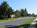
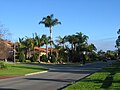
Marmion is a northern coastal suburb of Perth, the capital city of Western Australia. Its local government area is the City of Joondalup. Marmion was...
6 KB (649 words) - 02:51, 7 April 2024

freeway and the Yanchep line. The road terminates at a roundabout with Marmion Avenue, where it becomes Anchorage Drive North, a local distributor road in...
6 KB (452 words) - 14:18, 28 August 2024

east-west line near Eglinton Rocks to its north, Butler to the east (Marmion Avenue) and Quinns Rocks to the south (Hampshire Drive). West is the coast...
6 KB (653 words) - 07:15, 29 August 2024

to Whitfords station via Shenton Avenue & Oceanside Prom 461 to Whitfords station via Shenton Avenue & Marmion Avenue Stand 5 470 to Burns Beach via Iluka...
10 KB (614 words) - 05:35, 30 July 2024

and Clarkson station. The 471 service travels along Marmion Avenue, turns into Edinburgh Avenue and onto Kinross Drive, it travels to the most northerly...
6 KB (632 words) - 02:41, 20 August 2024

Western Australia. Whitfords Avenue is allocated State Route 83 east of Marmion Avenue, and Tourist Drive 204 (Sunset Coast Tourist Drive) between West Coast...
9 KB (634 words) - 14:12, 28 August 2024
15.13 9.40 H29 Marmion Avenue Marmion Avenue Karrinyup Mullaloo 12.20 7.58 H30 Port Beach Road Port Beach Road Walter Place Curtin Avenue North Fremantle...
20 KB (702 words) - 02:03, 4 January 2024

located in an enclave generally centred around the intersection of Marmion Avenue and Yanchep Beach Road, near the coast. For thousands of years prior...
18 KB (1,551 words) - 09:08, 1 August 2024
Island (Bronx). Crotona Park Hospital, 1790 Marmion Avenue, the Bronx Dr. Bregman's Sanitarium, 1884 Marmion Avenue, the Bronx. Dr. Morris Leff Maternity Hospital...
38 KB (3,855 words) - 11:24, 7 November 2023

(Reid Highway is located just a few hundred metres further north), Marmion Avenue to the west, Newborough Street to the south and Huntriss Road and the...
16 KB (1,085 words) - 20:29, 1 September 2024
by Hepburn Avenue to the south, Marmion Avenue to the east, Whitfords Avenue to the north and the coastal road portion of Whitfords Avenue (formerly part...
12 KB (1,278 words) - 08:44, 7 August 2024

complex provided a gateway. Sorrento is bounded by Hepburn Avenue to the north, Marmion Avenue to the east, Marine Terrace to the south and West Coast Drive...
9 KB (1,024 words) - 15:23, 29 August 2024
main road intersection of the east–west Whitfords Avenue (Route 83) and the north–south Marmion Avenue (Route 71). Many businesses and locations (shops...
1 KB (160 words) - 14:27, 7 May 2023

Currambine is bounded by Burns Beach Road to the north, Marmion Avenue to the west, Shenton Avenue to the south and Mitchell Freeway to the west. The suburb...
8 KB (644 words) - 06:30, 31 August 2024
Whitfords Station – serves Marmion Avenue 462 Joondalup Station to Whitfords Station – serves Hodges Drive and Marmion Avenue 463 Joondalup Station...
12 KB (1,367 words) - 13:58, 27 August 2024

dual carriageway for most of its length, changing to two lanes west of Marmion Avenue. A number of major intersections cross the road, most of which are controlled...
4 KB (323 words) - 06:06, 1 September 2024

Burns Beach. The road is a dual carriageway from Joondalup Drive to Marmion Avenue. Burns Beach Road provides direct access to Currambine railway station...
7 KB (700 words) - 12:23, 22 January 2024