
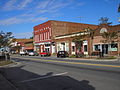
colonial era of Georgia. Milledgeville is the principal city of the Milledgeville micropolitan statistical area, a micropolitan area that includes Baldwin...
35 KB (2,617 words) - 16:48, 14 August 2024
The Milledgeville Micropolitan Statistical Area, as defined by the United States Census Bureau, is an area consisting of one county in Georgia, anchored...
5 KB (271 words) - 13:02, 22 September 2024
county seat of Hancock County, Georgia, United States. It used to be part of the Milledgeville micropolitan statistical area until 2023. The city's population...
13 KB (648 words) - 10:16, 16 September 2024

along the Oconee River. Baldwin County is part of the Milledgeville micropolitan statistical area. For centuries, the land was occupied by the Creek Nation...
21 KB (1,732 words) - 07:39, 22 September 2024

out around Central State Hospital. It is part of the Milledgeville Micropolitan Statistical Area. The zip code for Hardwick is 31034. Hardwick was home...
16 KB (618 words) - 22:06, 20 September 2024
is part of the Milledgeville Micropolitan Statistical Area. Culverton was named after Hardy Culver, an early resident. State of Georgia portal Central...
4 KB (127 words) - 23:46, 23 July 2023

part of the U.S. state of Georgia. The highway connects the Vidalia area with the Milledgeville area, via the Dublin area. SR 29 was originally designated...
23 KB (2,031 words) - 17:04, 25 July 2024

Georgia. As of the 2020 census, the population was 8,610. The county seat is Mount Vernon. Montgomery County is part of the Vidalia, GA micropolitan statistical...
19 KB (1,442 words) - 20:37, 23 April 2024

Terrell, member of Georgia House of Representatives,representing Hancock County State of Georgia portal Central Savannah River Area National Register of...
22 KB (1,474 words) - 11:50, 27 September 2024

S. state of Georgia. The highway connects Statesboro with the Watkinsville area, via Waynesboro, Louisville, Sandersville, Milledgeville, Eatonton, and...
68 KB (5,762 words) - 17:04, 25 July 2024

Fall Line Freeway (redirect from State Route 540 (Georgia))
between Gordon to south-southwest of Milledgeville. Between June 1960 and June 1963, I-75 was proposed in the Byron area. An unnumbered road was built from...
62 KB (6,099 words) - 00:38, 5 August 2024

across the state line from Phenix City, Alabama, to Comer, via Macon and Milledgeville. SR 22 originally traveled only from Columbus to Macon, and was incrementally...
53 KB (4,715 words) - 14:30, 30 May 2024
of Georgia. As of the 2020 census the population was 45,798. The county seat is Thomasville. Thomas County comprises the Thomasville, GA micropolitan statistical...
15 KB (849 words) - 19:49, 25 September 2024

state of Georgia. As of the 2020 census, the population was 30,144. The county seat is Jesup. Wayne County comprises the Jesup, Georgia micropolitan statistical...
25 KB (2,412 words) - 22:36, 9 July 2024

units. Dublin is the principal city of the Dublin micropolitan statistical area, a micropolitan area that covers Johnson and Laurens counties, and had...
31 KB (2,372 words) - 06:57, 27 September 2024

Chattahoochee Valley Community College (Phenix City) Georgia Military College - main campus in Milledgeville, Georgia Southern Union State Community College (Opelika)...
15 KB (700 words) - 06:31, 8 September 2024

County comprises the Kingsland, Georgia Micropolitan Statistical Area (μSA), formerly known as the St. Marys, Georgia μSA, which is included in the...
42 KB (4,173 words) - 15:46, 27 September 2024

Twiggs, Wilkinson, and Baldwin counties, and connects the Cairo and Milledgeville areas of the state. SR 112 begins at an intersection with US 84/SR 38 (Bill...
22 KB (1,467 words) - 22:00, 4 August 2024
delineated 7 combined statistical areas, 15 metropolitan statistical areas, and 24 micropolitan statistical areas within Georgia. As of 2023, the largest of...
28 KB (627 words) - 10:06, 11 July 2024
of micropolitan statistical areas in the United States. As defined by the United States Census Bureau, a micropolitan statistical area is the area (usually...
28 KB (1,117 words) - 00:32, 25 February 2024

central part of the U.S. state of Georgia. The highway connects SR 45 north of Dawson to SR 22/SR 24 in Milledgeville. The segment from Fort Valley to...
30 KB (1,944 words) - 13:50, 19 June 2024

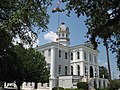
1782. In December 1804 the state legislature declared Milledgeville the new capital of Georgia. Savannah, a prosperous seaport throughout the nineteenth...
111 KB (9,237 words) - 19:05, 10 October 2024

Statistical area (United States) Combined statistical area (list) Core-based statistical area (list) Metropolitan statistical area (list) Micropolitan statistical...
332 KB (1,471 words) - 21:00, 27 September 2024

Sandersville areas was completed and opened to traffic in October 2016. In 2016, the new portion of highway was extended to SR 24 southeast of Milledgeville, and...
10 KB (1,059 words) - 17:04, 25 July 2024

Metro Atlanta (redirect from Atlanta Metropolitan Area)
University – Atlanta Georgia College – Milledgeville Georgia Gwinnett College – Lawrenceville Georgia Institute of Technology – Atlanta Georgia Piedmont Technical...
117 KB (9,767 words) - 13:16, 30 September 2024

is an 8.3-mile-long (13.4 km) bypass of US 441 in the Douglas, Georgia, micropolitan area that has existed since 2003. It is concurrent with SR 31 for entire...
25 KB (2,766 words) - 00:38, 28 July 2024

S. state of Georgia, east of its centerline. This route is part of a multi two-state route 15 that begins at Florida and ends at Georgia at the North...
83 KB (7,357 words) - 15:06, 20 July 2024

1995, the path of US 1, US 23, and SR 4 through the Waycross, Georgia micropolitan area was shifted to the west, replacing the route of SR 896. The former...
70 KB (7,790 words) - 23:34, 19 July 2024

(SR 11) is a 376-mile-long (605 km) state highway in the U.S. state of Georgia, traveling through portions of Echols, Lanier, Berrien, Irwin, Ben Hill...
77 KB (6,699 words) - 23:16, 29 September 2024

anchor for the metro area. Fields colored light yellow denote that the population is a micropolitan statistical area. An insular area is a United States...
123 KB (5,072 words) - 01:53, 18 August 2024