
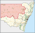
Narrabri Shire is a local government area in the North West Slopes region of New South Wales, Australia. The Shire is located adjacent to the Namoi River...
13 KB (813 words) - 03:36, 4 October 2023

Narrabri (/ˈnærəbraɪ/ NARR-ə-bry) is a locality and seat of Narrabri Shire local government area in the North West Slopes, New South Wales, Australia on...
21 KB (1,587 words) - 16:59, 29 June 2024
2MAX (redirect from Narrabri Shire Community Radio)
in 2000. 2MAX FM can be heard in Narrabri, Wee Waa, Coonabaraban, Gunnedah, Moree and throughout the Narrabri Shire, broadcasting 10 KWatts from the top...
4 KB (560 words) - 15:23, 16 April 2021

Boggabri (category Narrabri Shire)
north-eastern New South Wales, Australia. It is part of Narrabri Shire and lies between Gunnedah and Narrabri on the Kamilaroi Highway. At the 2021 census, the...
8 KB (743 words) - 21:38, 18 May 2024
Government Areas include Gunnedah Shire, Liverpool Plains Shire, Moree Plains Shire, Narrabri Shire, Gwydir Shire and Tamworth Regional Council. The...
7 KB (646 words) - 08:30, 25 August 2024

Baan Baa (category Narrabri Shire)
Wales, Australia in Narrabri Shire local government area and Pottinger County. It is approximately 38 kilometres south-east of Narrabri and 58 km north-west...
5 KB (435 words) - 02:43, 7 May 2024

Wee Waa (category Narrabri Shire)
is within the Narrabri Shire local government area and is on the Namoi River. Wee Waa is 41 kilometres (25 mi) north-west of Narrabri and 571 kilometres...
17 KB (1,483 words) - 02:14, 17 August 2024
dictionary. Etoo may refer to: Eto'o (surname), a Cameroonian surname Etoo, Narrabri Shire, Baradine County, New South Wales, Australia; a parish Etoo State Forest...
532 bytes (124 words) - 17:34, 6 September 2023
Bourke Shire, Brewarrina Shire, Narrabri Shire, Walgett Shire, Warrumbungle Shire, Coonamble Shire, Gilgandra Shire, Warren Shire, Bogan Shire, Lachlan...
9 KB (478 words) - 04:16, 29 October 2023

Pilliga, New South Wales (category Narrabri Shire)
west of Narrabri in the North West Plains section of the New England region of New South Wales, Australia. The village is within Narrabri Shire local government...
3 KB (276 words) - 04:58, 26 March 2022

Narrabri Airport (IATA: NAA, ICAO: YNBR) is an airport located 3 nautical miles (5.6 km; 3.5 mi) northeast of Narrabri, New South Wales, Australia. YNBR...
2 KB (85 words) - 14:41, 10 June 2024
Gwabegar (category Narrabri Shire)
town in North Eastern New South Wales, Australia. The town is in the Narrabri Shire local government area, 625 kilometres (388 mi) north west of the state...
3 KB (181 words) - 21:35, 19 October 2020
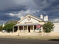
The Narrabri Gaol and Residence is a heritage-listed former gaol and now museum at Bowen Street, Narrabri, Narrabri Shire, New South Wales, Australia...
10 KB (1,164 words) - 01:23, 9 May 2022

Bellata (category Narrabri Shire)
is a small village in north-central New South Wales, Australia, in Narrabri Shire. At the 2021 census, Bellata had a population of 266. The place name...
4 KB (449 words) - 06:03, 20 July 2024
Its offices were based in the town of Narrabri. In 1937, Namoi Shire absorbed the Municipality of West Narrabri. The Local Government Areas Amalgamation...
2 KB (137 words) - 16:18, 29 April 2023

foliage C. columellaris bark Mature tree Green fruit, Narrabri Shire Mature fruit, Narrabri Shire Thomas, P. (2013). "Callitris columellaris". IUCN Red...
8 KB (661 words) - 04:04, 26 June 2024
civil parish of Baradine County, New South Wales. It is located in Narrabri Shire at 30°29′54″S 148°54′04″E and is within the Pilliga National Park. "Baradine"...
857 bytes (93 words) - 19:12, 5 March 2024
Euligal located at 30°41′54″S 149°05′04″E in Narrabri Shire is a civil parish of Baradine County, New South Wales. Euligal is in the Pilliga forest. Robert...
796 bytes (90 words) - 19:34, 5 March 2024
of the Narrabri Shire, Goulburn Mulwaree Council, Walgett Shire, Cobar Shire and almost the entire Lachlan Shire, Bland Shire and the Bogan Shire. The Bogan...
1 KB (145 words) - 06:41, 20 June 2020
Retrieved 7 July 2017. Australian Bureau of Statistics (27 June 2017). "Narrabri (A)". 2016 Census QuickStats. Retrieved 7 July 2017. Australian Bureau...
52 KB (2,825 words) - 08:12, 19 June 2024
Society for Cancer Relief, a British charity Narrabri Shire Community Radio, a community radio station in Narrabri, New South Wales, Australia National Security...
733 bytes (132 words) - 19:48, 16 April 2021
13 December 2011. "Narrabri Old Gaol and Museum". Retrieved 27 June 2018. "Narrabri Shire Information Directory | Visit Narrabri". visitnarrabri.com...
66 KB (1,837 words) - 07:33, 28 August 2024
by the username Aush0k, was arrested for the alleged hacking of the Narrabri Shire Council website on which homepage sexually explicit text and an image...
119 KB (11,054 words) - 01:45, 1 September 2024

Edgeroi (category Narrabri Shire)
township in the northwest of New South Wales, Australia, located between Narrabri and Moree. The Newell Highway and the North-West railway line pass through...
3 KB (222 words) - 06:24, 18 July 2023

attractions were closed to the public. "Narrabri Region Information Directory- Mount Kaputar National Park". Narrabri Shire Council. Retrieved 18 February 2020...
4 KB (328 words) - 15:57, 1 January 2022

May 2016. Retrieved 13 May 2016. "Wentworth - A Brief History". Wentworth Shire Council. Retrieved 16 February 2020. "Local Government Act, 1919—Proclamation"...
72 KB (2,347 words) - 02:13, 5 September 2024
-30.350; 148.900 Population 273 (2006 census) Postcode(s) 2388 LGA(s) Narrabri Shire County Baradine County State electorate(s) Barwon, Tamworth Federal...
1 KB (95 words) - 19:03, 5 March 2024

Burren Junction (category Walgett Shire)
Junction Post Office opened on 16 May 1904. Burren Junction is in the Walgett Shire local government area and Jamison County. The village sits at an elevation...
4 KB (447 words) - 04:41, 5 May 2024
of New South Wales. It is located to the east of the Namoi River, with Narrabri at the north-west edge, and Gunnedah at the southern edge. Nandewar County...
6 KB (109 words) - 06:57, 6 August 2024

Coordinates Belar Narrabri Shire 29°58′54″S 149°34′04″E / 29.98167°S 149.56778°E / -29.98167; 149.56778 (Belar) Bibil Narrabri Shire 29°58′54″S 149°40′04″E...
10 KB (100 words) - 06:55, 6 August 2024