Narus is a community in the Eastern Equatoria State of South Sudan. It is the headquarters of Kapoeta East County. Narus is 25 kilometres (16 mi) north...
13 KB (894 words) - 17:22, 7 May 2024
Narus may refer to: Narus, South Sudan, a Payam in Eastern Equatoria State of South Sudan Narus River, Kapoeta, a river in Kapoeta East County of South...
320 bytes (79 words) - 11:34, 3 February 2023
The Narus River may refer to: Narus River, Kapoeta, which mainly flows through Kapoeta East County in South Sudan Narus River, Uganda, which mainly flows...
293 bytes (67 words) - 16:55, 9 July 2015
of South Sudan, about 50 kilometres (31 mi) as the crow flies to the north east of Narus. It lies on the Loyoro River. Loyoro is part of the Narus parish...
7 KB (299 words) - 17:34, 7 May 2024
The Narus River originates in the east of the Didinga Hills in the erstwhile Eastern Equatoria State, South Sudan. It flows eastward and discharges into...
3 KB (151 words) - 20:41, 29 September 2019

US, Germany, Nigeria, Tanzania, Kenya, and Sudan. She has performed on the continents of North America, South America, Europe, and Africa. EP 2011 : Poetry:...
3 KB (335 words) - 19:04, 19 August 2024

Kabekenyang/Natinga payam includes the villages of Natinga and Kabekenyan. Narus payam includes Narus and Nadapal. The pastoral people own large numbers of cattle,...
17 KB (1,323 words) - 11:31, 6 May 2024

White Nile (category Rivers of South Sudan)
Victoria via Lake Kyoga to Lake Albert, then the "Albert Nile" to the South Sudan border, and then the "Mountain Nile" or "Bahr-al-Jabal" down to Lake...
18 KB (1,697 words) - 13:55, 29 July 2024
southward from the border with South Sudan to Lokichogio in Kenya. The village of Nadapal lies on the road between Narus in South Sudan and Lokichogio. The area...
13 KB (1,342 words) - 17:28, 7 February 2023

Kapoeta (category Kapoeta South County)
Kapoeta is a town in South Sudan. It is located in Kapoeta South County, in Eastern Equatoria State, in southeastern South Sudan. The town lies on the...
7 KB (372 words) - 21:11, 13 June 2024

entering Eastern Equatoria state of South Sudan. The name Narus is derived from the Karamajong word for mud. The Narus Valley has a 40% higher mean annual...
4 KB (241 words) - 15:48, 11 July 2024

Kapoeta State (category South Sudan articles missing geocoordinate data)
180 counties in South Sudan. The 8 counties are consisted of the following: Budi; headquarters: Chukudum Kapoeta East; headquarters: Narus Kapoeta North;...
5 KB (363 words) - 15:25, 23 April 2024

Roman Catholic Diocese of Torit (category Roman Catholic dioceses in South Sudan)
runs two secondary schools (Narus and Isohe), one vocational school (Narus), and 13 primary schools (Boma, Nanyangachor, Narus, Lolim, Isoke, Ikotos, Iboni...
5 KB (474 words) - 02:15, 7 July 2024

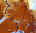
Kidepo Valley National Park (section Narus Valley)
89 cm (35 in) in Narus and 64 cm (25 in) in the Kidepo valleys, vegetation and animal populations vary between the two valleys. Narus is a name given by...
13 KB (1,225 words) - 08:40, 12 August 2024
with Ethiopia. Nanyangachor is about 180 kilometres (110 mi) northeast of Narus, in the dry season about a five-hour drive. In the rainy season the drive...
10 KB (541 words) - 17:30, 7 May 2024
Lolim (category South Sudan geography stubs)
community located in Eastern Equatoria state of South Sudan. It is on the road from Kapoeta to Narus. Lolim lies just north of the Loyuro River, which...
6 KB (175 words) - 17:20, 7 May 2024
that even in Khartoum, the Toposa militiamen became very active on the Narus-Kapoeta roads. Tried to disrupt and block SPLA activities along this international...
11 KB (808 words) - 17:40, 11 July 2024
Kidepo Game Reserve (category Game reserves of South Sudan)
Eastern Equatoria State, South Sudan, Africa. With an area of 1200 km2, this reserve is located 4° 04'N and 33° 28'E on the South Sudan/Uganda border, where...
4 KB (315 words) - 13:40, 21 April 2023
Loyuro River (category Rivers of South Sudan)
into Greater Kapoeta and discharging into the swampy area northeast of Narus. The river floods during the rainy season, but ceases to flow at other times...
1 KB (143 words) - 12:49, 7 August 2024
Kuron peace village (category 2005 establishments in Sudan)
South Sudan, in 2005. It is situated in Kapoeta East County, Namorunyang State, on the southeast border of South Sudan, roughly 190 km from Narus and...
5 KB (267 words) - 12:39, 6 May 2024

stream's name. Nile White Nile (Bahr al Jabal) (Albert Nile) Kidepo River Narus River Achwa River Pager River Ora River Nyagak River Victoria Nile River...
2 KB (157 words) - 19:06, 11 September 2024

Toposa people (category Ethnic groups in South Sudan)
The Toposa are a Nilotic ethnic group in South Sudan, living in the Greater Kapoeta region of Eastern Equatoria state. They have traditionally lived by...
27 KB (3,225 words) - 15:34, 3 September 2024
Didinga Hills (category South Sudan geography stubs)
are an upland area in Eastern Equatoria of South Sudan, lying mainly within Budi County. The Nakodok, Narus and Loyoro rivers originate in the east of...
4 KB (272 words) - 11:11, 2 June 2021

course enters South Sudan. At the southern end of the lake, where the Semliki comes in, there are swamps. The Rwenzori Mountains are to the south of the lake...
16 KB (1,610 words) - 07:53, 6 September 2024
List of teen dramas (section South Africa)
Yedili [tr] (2011–13), Show TV Sana Bir Sır Vereceğim [tr] (2013–14), Fox Turkey Sudan Bıkmış Balıklar (2012), Star TV Early Swallows (2019–20), Novyi Kanal Novenka [uk]...
163 KB (14,150 words) - 14:45, 12 September 2024
South Africa. 2010. p. 3. ISBN 978-0-621-39563-1. Cooper, John (June 2006). "Antarctica and Islands: Background Research Paper produced for the South...
87 KB (460 words) - 03:21, 8 May 2024
Such a Long Journey (1998) Sucker Punch: (2008 & 2011) The Suckers (1972) Sudan (1945) Sudden Death: (1977 & 1995) Sudden Fear (1952) Sudden Impact (1983)...
178 KB (14,603 words) - 22:12, 16 September 2024
List of marines and similar forces (section Sudan)
ලංකා මැරීන් බලකාය - Śrī Laṁkā Mærīn Baḷakāya) 101st Marine Division "Port Sudan" Amphibious Corps (Amfibiekåren) 1st Marine Regiment (Amfibieregementet)...
284 KB (21,971 words) - 18:48, 14 September 2024
Achwa River (category Rivers of South Sudan)
northeastern highlands, before crossing the border into South Sudan where it joins the White Nile. In South Sudan it is known as the Aswa River. The river is a...
3 KB (137 words) - 17:28, 15 July 2024
List of paratrooper forces (section Sudan)
("Vytauto Didžiojo" Jegerių Batalionas) Navy Combat Divers Service (Kovinių Narų Tarnyba) Air Force Special Operations Team (Specialiųjų Operacijų Grandis)...
335 KB (23,708 words) - 04:19, 4 September 2024