several neighborhoods in South Worcester and East Worcester. Park Ave skirts the eastern edge of West Worcester. The Edgemere neighborhood is primarily in neighboring...
6 KB (203 words) - 00:26, 24 July 2024

Worcester (/ˈwʊstər/ WUUST-ər, locally [ˈwɪstə] ) is the second-most populous city in the U.S. state of Massachusetts and the 114th most populous city...
127 KB (11,130 words) - 21:06, 15 October 2024

a residential historic district in northwestern Worcester, Massachusetts. It is a portion of a subdivision laid out in 1897 on the estate of Jared Whitman...
4 KB (349 words) - 17:41, 22 June 2024
mayor of Worcester, Massachusetts. Worcester held its first direct election for mayor in 1987. The city has a council–manager government in which the...
95 KB (5,344 words) - 23:35, 14 February 2024
Grafton Hill (category Neighborhoods in Worcester, Massachusetts)
known as Sagatabscot Hill is a neighborhood in Worcester, Massachusetts (the second-largest city in New England). Located in the southeastern part of the...
1 KB (144 words) - 01:00, 18 January 2022

Kelley Square (category Neighborhoods in Worcester, Massachusetts)
Kelley Square is a square located in Worcester, Massachusetts, at the intersection of Massachusetts Route 122 and 122A, with ramp access to and from Interstate...
7 KB (417 words) - 01:07, 25 July 2024

Lincoln Estate–Elm Park Historic District (category Neighborhoods in Worcester, Massachusetts)
in northwestern Worcester, Massachusetts National Register of Historic Places listings in Worcester County, Massachusetts Neighborhoods of Worcester,...
3 KB (163 words) - 14:09, 8 September 2024

The Massachusetts Avenue Historic District in Worcester, Massachusetts is a 5-acre (2.0 ha) historic district that was listed on the National Register...
3 KB (190 words) - 00:37, 8 August 2023

passing the University of Massachusetts Amherst and Amherst College. From Amherst, it wends its way into western Worcester County, south of the Quabbin...
24 KB (1,205 words) - 13:41, 23 September 2024

Indian Hill-North Village (redirect from Indian Hill-North Village, Massachusetts)
worker housing community in Worcester, Massachusetts. Located in the suburban northern part of the city, it was developed in the 1910s by the Norton Company...
4 KB (469 words) - 17:23, 22 June 2024
in Worcester, Massachusetts. Andrew Schiller conceived NeighborhoodScout while working on his doctorate in geography at Clark University in Worcester...
10 KB (928 words) - 19:48, 3 August 2024

Hammond Heights (category Neighborhoods in Worcester, Massachusetts)
Hammond Heights is an historic neighborhood subdivision on the west side of Worcester, Massachusetts. It includes properties along Germain, Haviland,...
3 KB (284 words) - 22:33, 6 August 2023

Worcester Regional Airport (IATA: ORH, ICAO: KORH, FAA LID: ORH) is three miles (5 km) west of Worcester, in Worcester County, Massachusetts, United States...
41 KB (3,950 words) - 19:28, 21 September 2024

Worcester State Hospital was a Massachusetts state mental hospital located in Worcester, Massachusetts. It is credited to the architectural firm of Weston...
9 KB (786 words) - 15:20, 25 April 2024
The following is a timeline of the history of the city of Worcester, Massachusetts, United States of America. 1669 – Common established.[citation needed]...
28 KB (2,280 words) - 14:10, 8 September 2024

The 1953 Worcester tornado was an extremely powerful and destructive tornado that struck the city of Worcester, Massachusetts and surrounding areas on...
18 KB (1,866 words) - 20:31, 29 September 2024

Greater Boston (redirect from Worcester, Massachusetts metropolitan area)
Massachusetts Norfolk County, Massachusetts Plymouth County, Massachusetts Suffolk County, Massachusetts Worcester County, Massachusetts New Hampshire Belknap...
73 KB (3,388 words) - 12:05, 26 September 2024

Main South (category Neighborhoods in Worcester, Massachusetts)
Main South (or South Main) is a neighborhood in southern Worcester, Massachusetts. The area's eponymous feature is Main Street, the central roadway of...
3 KB (259 words) - 15:41, 22 April 2021
Worcester State University (WSU) is a public university in Worcester, Massachusetts. The fourth largest of the Commonwealth’s nine Universities, WSU enrolls...
18 KB (1,988 words) - 02:41, 5 September 2024
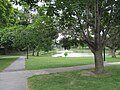
Park, also called Crystal Park, is a public park in the Main South neighborhood of Worcester, Massachusetts. The 13-acre (53,000 m2) park was acquired by...
2 KB (207 words) - 15:03, 25 April 2024

Sturbridge is a town in Worcester County, Massachusetts, United States. It is home to Old Sturbridge Village living history museum and other sites of historical...
17 KB (1,431 words) - 22:08, 17 September 2024
The Grid District (category Neighborhoods in Worcester, Massachusetts)
The Grid District is a collection of buildings in downtown Worcester, Massachusetts. When finished, the Grid District will have 510 residential units,...
3 KB (385 words) - 13:57, 13 October 2019

synagogue building located at 32 Providence Street, Worcester, Massachusetts, in the United States. Worcester's first Modern Orthodox "shul" (and 6th overall)...
15 KB (966 words) - 10:30, 18 August 2024
Fairlawn, Massachusetts Fairlawn (Worcester, Massachusetts), listed on the National Register of Historic Places in Worcester County, Massachusetts Fairlawn...
827 bytes (117 words) - 04:45, 7 April 2015

Three-decker (house) (category Apartment buildings in the United States)
three-decker homes attracted live-in landlords who would collect rent from the other two apartments. In Worcester, Massachusetts, sewer connection charges were...
12 KB (1,257 words) - 02:20, 6 September 2024

Southbridge is a city in Worcester County, Massachusetts, United States. The population was 17,740 at the 2020 census. Although Southbridge has a city...
18 KB (1,907 words) - 21:47, 15 October 2024
This is a list of lists of neighborhoods in cities around the world. An asterisk indicates a separate article. Cape Town * Durban * Johannesburg * Pretoria...
11 KB (360 words) - 14:03, 12 September 2024

well in poor Catholic precincts of Massachusetts and Rhode Island, where he even outpolled Landon in all Irish neighborhoods save Brighton. In the poorest...
19 KB (761 words) - 20:09, 4 October 2024

occurring in Flint, Michigan, on June 8 and an F4 tornado in Worcester, Massachusetts, on June 9. These tornadoes are among the deadliest in United States...
53 KB (1,950 words) - 18:30, 29 August 2024

Holden is a town in Worcester County, Massachusetts, United States. The town was founded in 1741, and the Town Square (Center, Common) was donated by John...
11 KB (1,174 words) - 17:14, 15 October 2024