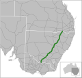
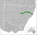
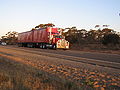
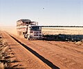
Newell Highway is a national highway in New South Wales (NSW), Australia. It provides the major road link between southeastern Queensland and Victoria...
31 KB (2,359 words) - 06:47, 19 April 2024
Gilgandra, where it intersects with Castlereagh Highway. It shares a concurrency with Newell Highway from there to Coonabarabran, where it splits off...
16 KB (1,293 words) - 15:53, 28 November 2023
Newell may refer to: Newell, Queensland, a locality in the Shire of Douglas Newell Highway, New South Wales County of Newell, a municipal district in Alberta...
936 bytes (126 words) - 21:45, 21 June 2022

Australia. The highway services rural communities and links the Great Western, Mitchell, Olympic, Newell, Cobb and Sturt highways. Mid-Western Highway forms part...
17 KB (1,372 words) - 05:53, 15 February 2024

intersection with Mitchell Highway at Bourke, and heads in an easterly direction through Brewarrina and Walgett to meet Newell Highway in northern Narrabri...
17 KB (1,418 words) - 01:48, 19 August 2023

intersection with New England Highway just north of Tenterfield. Bruxner Highway commences at the intersection with Newell Highway in central Tenterfield and...
17 KB (1,333 words) - 14:53, 1 March 2024

Leichhardt Highway is a major transport route in Queensland, Australia. It is a continuation northward from Goondiwindi of the Newell Highway, via a 2.0-kilometre...
9 KB (266 words) - 22:59, 27 May 2024

to Sydney, and is designated route B84. Golden Highway commences at the intersection with Newell Highway in Dubbo and heads in an easterly direction as...
13 KB (1,001 words) - 01:33, 12 June 2024

Gore Highway is a highway running between Toowoomba and Goondiwindi in Queensland, Australia. Together with Goulburn Valley Highway and Newell Highway, it...
12 KB (954 words) - 05:22, 14 June 2024
Landsborough, Barkly and Stuart Highways Brisbane to Melbourne – Warrego, Gore, Newell and Goulburn Valley Highways and Hume Freeway Melbourne to Adelaide...
37 KB (2,677 words) - 05:59, 11 January 2024

Kidman Way (category Highways in New South Wales)
643-kilometre (400 mi) highway services the Murrumbidgee Irrigation Area and outback communities and links the Newell Highway with the Sturt, Mid-Western...
20 KB (1,741 words) - 08:46, 15 January 2024

Sydney on the Kamilaroi Highway. At the 2021 census, Wee Waa had a population of 2,034. Wee Waa is 42 kilometres from the Newell Highway, and is referred to...
17 KB (1,458 words) - 08:02, 26 June 2024

Central West (New South Wales) (category Newell Highway)
traversed by the Great Western Highway, the Mid-Western Highway, the Mitchell Highway, the Newell Highway and the Castlereagh Highway. The Central West has several...
10 KB (624 words) - 13:56, 10 April 2024
Kamilaroi Highways. Continuing south through Coonamble, the highway crosses the Castlereagh River and meets the Oxley and Newell Highways in Gilgandra...
21 KB (1,617 words) - 20:23, 18 May 2024

Valley Highway commences on the southern bank of the Murray River, forming the interstate border with New South Wales, and continues south from Newell Highway...
32 KB (2,313 words) - 03:29, 3 July 2024

Forbes, New South Wales (category Newell Highway)
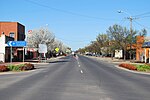
the Central West region of New South Wales, Australia, located on the Newell Highway between Parkes and West Wyalong. At the 2021 census, Forbes had a population...
28 KB (2,494 words) - 00:03, 9 May 2024
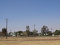
Riverina region of New South Wales, Australia. The town is situated on the Newell Highway, 23 kilometres (14 mi) east of Narrandera in the Shire of Narrandera...
8 KB (590 words) - 03:08, 20 June 2024

Narrabri (category Newell Highway)
northwest of Sydney. It sits on the junction of the Kamilaroi Highway and the Newell Highway. At the 2021 census, the town of Narrabri had a population of...
21 KB (1,587 words) - 16:59, 29 June 2024

Dubbo (category Newell Highway)
June 2021. The city is located at the intersection of the Newell, Mitchell, and Golden highways. Dubbo officially became a city in the year 1966. Dubbo...
46 KB (4,460 words) - 17:52, 23 June 2024
connector roads and smaller highways are zoned 60 km/h (37 mph), 70 km/h (43 mph), 80 km/h (50 mph) or 90 km/h (56 mph). Some highways and freeways are zoned...
34 KB (3,586 words) - 00:42, 2 June 2024
Sturt Highway is an Australian national highway in New South Wales, Victoria, and South Australia. It is an important road link for the transport of passengers...
38 KB (3,130 words) - 11:11, 28 March 2024
Wales, the highway's south-eastern terminus is at its junction with Great Western and Mid-Western Highways, and it links with Golden, Newell, Oxley, Barrier...
22 KB (1,557 words) - 05:19, 15 February 2024
along with Taronga Zoo Sydney. Western Plains Zoo is located on the Newell Highway in west Dubbo about 5 km from the city. In the late 1960s, plans to...
8 KB (595 words) - 16:34, 20 March 2024

it is concurrent with Sturt Highway. Olympic Highway approximately parallels Hume Highway to the east and Newell Highway to the west, sharing a short...
19 KB (1,515 words) - 14:30, 22 June 2024

Narrandera (category Newell Highway)
South Wales, Australia. The town lies on the junction of the Newell and Sturt highways, adjacent to the Murrumbidgee River, and it is considered the...
25 KB (2,639 words) - 04:14, 21 June 2024
Jerilderie (category Newell Highway)
Jerilderie had a population of 922 people. It can be found along the Newell Highway 674 kilometres (419 mi) west-southwest of Sydney and 45 kilometres (28 mi)...
19 KB (2,013 words) - 03:55, 22 April 2024

the highway passes through or near the Riverina towns of Howlong, Corowa, Berrigan and Finley where it has a short concurrency with Newell Highway. From...
13 KB (951 words) - 15:44, 26 March 2024

the Dubbo Regional Council local government area and adjacent to the Newell Highway, 423 kilometres (263 mi) north west of the state capital Sydney and...
1 KB (83 words) - 21:46, 22 June 2024

West Wyalong (category Newell Highway)
is situated on the crossroads of the Newell Highway between Melbourne and Brisbane, and the Mid-Western Highway between Sydney and Adelaide. The West...
17 KB (1,218 words) - 22:11, 18 May 2024
Finley, New South Wales (category Newell Highway)
kilometres (87 mi) west of Albury on the intersection of the Newell Highway and Riverina Highways. Europeans first settled the area around Finley in the early...
7 KB (693 words) - 11:21, 10 April 2024