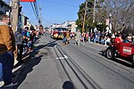
North East is a town in Cecil County, Maryland, United States. It is located between Philadelphia and Baltimore. The population was 3,572 at the 2010 census...
11 KB (1,085 words) - 20:35, 2 May 2024
First Avenue east to MD 904F in Emmitsburg. Maryland Route 909 is the unsigned designation for MD 424 Service Road, which runs from MD 424 north to a dead...
97 KB (8,242 words) - 21:28, 4 May 2024
North Bethesda is an unincorporated, census-designated place (CDP) in Montgomery County, Maryland, United States, located just north-west of the U.S. capital...
26 KB (2,556 words) - 00:00, 31 May 2024
continues north as county-maintained New London Road north toward New London. Maryland Route 877 (officially MD 877B) is the designation for East Baldwin...
96 KB (8,306 words) - 02:37, 5 May 2024
The following is a list of state highways in Maryland shorter than one mile (1.6 km) in length with route numbers between 2 and 699. Most of these highways...
89 KB (7,809 words) - 21:37, 4 May 2024

North East High School (NEHS) is a public high school in North East, Maryland on 300 Irishtown Road. It is part of the Cecil County Public Schools system...
4 KB (253 words) - 19:31, 23 February 2024
Northeast (disambiguation) (redirect from North East)
Aberdeenshire and Moray North East (Dundee ward), Scotland North East (Glasgow ward), Scotland North East, Maryland North East, New York North East, Pennsylvania...
5 KB (550 words) - 17:40, 5 February 2024
North East High School may refer to: North East High School (Kansas) — Arma, Kansas North East High School (Maryland) — North East, Maryland North East...
379 bytes (78 words) - 14:41, 14 May 2010

groves in the Maryland mountains to the west. Maryland is bounded on its north by Pennsylvania, on its north and east by Delaware, on its east by the Atlantic...
216 KB (18,716 words) - 14:27, 3 July 2024
to the east, where it receives an exit ramp from westbound MD 4. Maryland Route 727 is the designation for a pair of streets named Old North Road parallel...
48 KB (3,564 words) - 02:44, 5 May 2024
Cecil College (category Community and junior colleges in Maryland)
Cecil College is a public community college in North East, Maryland in Cecil County. Cecil College was founded in 1968 to meet the educational needs of...
3 KB (166 words) - 23:52, 8 July 2024
The Maryland highway system has several hundred former state highways. These highways were constructed, maintained, or funded by the Maryland State Roads...
104 KB (12,452 words) - 18:24, 21 August 2023

North Potomac is a census-designated place and unincorporated area in Montgomery County, Maryland, United States. It is located less than 5 miles (8.0 km)...
60 KB (5,662 words) - 22:35, 3 April 2024

sometimes called the Shawnace also moved into what later became North East, Maryland. Captain John Smith visited the area in 1608. William Claiborne,...
45 KB (4,207 words) - 21:20, 18 June 2024
The Maryland highway system has several hundred former state highways. These highways were constructed, maintained, or funded by the Maryland State Roads...
86 KB (9,107 words) - 23:20, 15 May 2024
Baltimore County, Maryland, United States. It is bordered by the main portion of Arbutus to the north, Baltimore to the North East, Elkridge to the South...
6 KB (319 words) - 10:43, 24 June 2024

Sacramento, California, east to Ocean City, Maryland, on the Atlantic Ocean. In the U.S. state of Maryland, US 50 exists in two sections. The longer of...
88 KB (8,167 words) - 16:08, 5 July 2024

US 40; Maryland Route 268 which follows North Street from Main Street in downtown Elkton north to MD 279; Maryland Route 281, which heads east along Red...
29 KB (3,019 words) - 18:18, 8 July 2024

The North East River is a tributary of the Chesapeake Bay in Maryland. Entirely tidal, it extends for about 5.0 miles (8.0 km) from the town of North East...
2 KB (171 words) - 20:37, 16 January 2024

Maryland Route 4 (MD 4) is a state highway in the U.S. state of Maryland. The highway runs 64.85 miles (104.37 km) from MD 5 in Leonardtown north to Southern...
35 KB (3,109 words) - 19:35, 8 January 2024
The Maryland highway system has several hundred former state highways. These highways were constructed, maintained, or funded by the Maryland State Roads...
71 KB (8,267 words) - 22:03, 30 October 2023

Connecticut, Delaware, Florida, Georgia, Maine, Maryland, Massachusetts, New Hampshire, New Jersey, New York, North Carolina, Rhode Island, South Carolina, and...
33 KB (2,231 words) - 17:50, 6 July 2024

North Laurel is a census-designated place (CDP) in Howard County, Maryland, United States. The published population was 4,474 at the 2010 census. This...
24 KB (2,787 words) - 20:12, 7 November 2023

The Eastern Shore of Maryland is a part of the U.S. state of Maryland that lies mostly on the east side of the Chesapeake Bay. Nine counties are normally...
42 KB (3,325 words) - 23:21, 21 February 2024
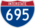
Interstate Highway that constitutes a beltway extending around Baltimore, Maryland, United States. I-695 is officially designated the McKeldin Beltway but...
61 KB (5,242 words) - 16:27, 12 June 2024

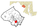
Maryland's 2nd congressional district elects a representative to the United States House of Representatives every two years. The district comprises parts...
54 KB (1,167 words) - 09:27, 30 April 2024

Mason–Dixon line (redirect from North–South divide in the United States)
proceeded nearly due north from this to the Pennsylvania border.[citation needed] The Maryland–Pennsylvania boundary is an east–west line with an approximate...
50 KB (5,743 words) - 15:38, 24 June 2024

Baltimore County: Loyola College in Maryland (in Hunt Valley, main campus in Baltimore at North Charles Street and East Cold Spring Lane, [formerly Loyola...
66 KB (6,125 words) - 21:20, 18 June 2024

Maryland Route 2 (MD 2) is the longest state highway in the U.S. state of Maryland. The 79.24-mile (127.52 km) route runs from Solomons Island in Calvert...
77 KB (7,972 words) - 16:05, 15 May 2024

Baltimore (redirect from East Baltimore, Maryland)
Street to the north, and Martin Luther King Jr. Boulevard and Russell Street/Baltimore-Washington Parkway (Maryland Route 295) to the east. Notable neighborhoods...
260 KB (23,495 words) - 21:26, 30 June 2024