series of strata at Okse Bay, characterized by sandstones, mudstones, and shale, are referred to as the Okse Bay Formation. "Okse Bay". Geographical Names...
1 KB (112 words) - 16:18, 2 September 2024
The Okse Bay Group is a geologic group in Northwest Territories. It preserves fossils dating back to the Devonian period. Earth sciences portal Canada...
1 KB (60 words) - 11:50, 14 February 2024
The Okse Bay Formation is an Upper Devonian formation found in Okse Bay, in the Qikiqtaaluk Region, Nunavut of Northern Canada. The formation contains...
1 KB (80 words) - 16:17, 2 September 2024

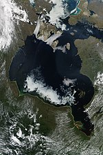
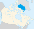
James Bay (French: Baie James; Cree: ᐐᓂᐯᒄ, romanized: Wînipekw, lit. 'dirty water') is a large body of water located on the southern end of Hudson Bay in...
17 KB (2,050 words) - 01:36, 2 August 2024
entrance to the bay is marked by Fitzjames Island on the west and Irving Island to the east. The bay opens to Queen Maud Gulf. The bay was one of a series...
5 KB (501 words) - 01:30, 9 June 2024
Hudson Bay, sometimes called Hudson's Bay (usually historically), is a large body of saltwater in northeastern Canada with a surface area of 1,230,000 km2...
55 KB (6,203 words) - 06:55, 28 September 2024
Baffin Bay (Inuktitut: Saknirutiak Imanga; Greenlandic: Avannaata Imaa; French: Baie de Baffin; Danish: Baffinbugten), located between Baffin Island and...
22 KB (2,422 words) - 02:55, 3 September 2024

Frobisher Bay is an inlet of the Davis Strait in the Qikiqtaaluk Region of Nunavut, Canada. It is located in the southeastern corner of Baffin Island...
7 KB (749 words) - 17:52, 20 August 2024

on the northern shore of the bay with Resolute Bay Airportmap to the northwest. The Inuit associated with Resolute Bay are called Qausuittuq and the...
7 KB (564 words) - 19:40, 2 September 2024

been found Type Geological formation Unit of Okse Bay Group Underlies Hell Gate Formation Overlies Hecla Bay Formation Thickness 10 to 20 meters Lithology...
8 KB (458 words) - 16:35, 25 April 2024
Ordovician Marvin Formation Silurian Nansen Formation Permian, Carboniferous Okse Bay Formation / Fram Formation Devonian Otto Fiord Formation Carboniferous...
4 KB (31 words) - 15:27, 2 September 2024
Wilmot and Crampton Bay is an Arctic waterway in the Kitikmeot Region, Nunavut, Canada . It is located on the eastern edge of Queen Maud Gulf, running...
3 KB (314 words) - 18:10, 23 May 2024
Ungava Bay (French: baie d'Ungava, pronounced [bɛ d‿œ̃ɡava]; Inuktitut: ᐅᖓᕙ ᑲᖏᖅᓗᒃ/ungava kangiqluk) is a bay in Nunavut, Canada separating Nunavik (far...
5 KB (582 words) - 22:37, 2 September 2024
Shepherd Bay is an Arctic waterway in the Kitikmeot Region, Nunavut, Canada. Located off the western Boothia Peninsula , the bay is on the north side...
2 KB (215 words) - 14:21, 3 September 2024
Devonian Okse Bay Group/Norstrand Formation Devonian Pine Point Formation Devonian Ramparts Formation Devonian Rat River Formation Cretaceous Read Bay Formation...
5 KB (79 words) - 18:28, 8 February 2024
Tasiujaq (Inugsuin Fiord) (redirect from Igloo Bay)
Tasiujaq, previously Igloo Bay is an uninhabited bay of Baffin Island in the Qikiqtaaluk Region, Nunavut, Canada. It flows into Inugsuin Fiord and then...
1 KB (83 words) - 19:14, 28 August 2024
Simpson Peninsula. Helen Island lies in the bay. Pelly Bay is named after Sir John Pelly, governor of the Hudson's Bay Company, that managed the British territory...
4 KB (295 words) - 15:28, 23 May 2024
Wager Bay or Ukkusiksalik Bay is long narrow inlet in the Kivalliq Region of Nunavut, Canada, which opens east into Roes Welcome Sound at the northwest...
4 KB (306 words) - 18:41, 23 June 2024
Pioneer Bay is a waterway in the Qikiqtaaluk Region, Nunavut, Canada. It lies off the western coast of Cornwallis Island in the eastern high Arctic. It...
1 KB (90 words) - 18:21, 2 September 2024
Sabine Bay is an Arctic waterway in the Qikiqtaaluk Region, Nunavut, Canada. The bay flows into Frobisher Bay off Baffin Island. "Sabine Bay". Geographical...
881 bytes (36 words) - 20:01, 2 September 2024
Bowman Bay is an Arctic waterway in the Qikiqtaaluk Region, Nunavut, Canada. It is located in the Foxe Basin by northeastern Foxe Peninsula off Baffin...
2 KB (195 words) - 01:27, 9 June 2024
M'Clure Bay (variant: McClure Bay) is a Peel Soundmap waterway in the Qikiqtaaluk Region, Nunavut, Canada. It is located on the western side of Somerset...
2 KB (215 words) - 21:47, 24 August 2024
Augusta Bay is a bay of the Ellesmere Island, Nunavut, Canada. Meltwater from the Prince of Wales Icefield channels into the bay with its mouth opening...
1 KB (63 words) - 21:43, 30 May 2024
Stuart Bay is an Arctic waterway in the Qikiqtaaluk Region, Nunavut, Canada. Located off the north of Cornwallis Island, the bay is on the south side...
1,012 bytes (59 words) - 22:14, 2 September 2024
Lady Franklin Bay is an Arctic waterway in the Qikiqtaaluk Region, Nunavut, Canada. The bay is located in Nares Strait, northwest of Judge Daly Promontory...
6 KB (728 words) - 20:32, 24 August 2024
Triton Bay is an Arctic waterway in the Qikiqtaaluk Region, Nunavut, Canada. It is located in Norwegian Bay off Devon Island's Grinnell Peninsula. To the...
957 bytes (51 words) - 22:17, 2 September 2024
Cameron Bay is an Arctic waterway in the Qikiqtaaluk Region, Nunavut, Canada. Located off northeastern Cameron Island, the bay is an arm of the Arctic...
1 KB (60 words) - 21:49, 16 June 2024
Bay is an Arctic waterway in the Kitikmeot Region, Nunavut, Canada. It is located in the southern Queen Maud Gulf off Nunavut's mainland. Chester Bay...
2 KB (114 words) - 15:14, 23 May 2024
Campbell Bay and Chester Bay are nearby. The mouth of Kuunajuk, formerly Ellice River, opens between Gernon Bay and Campbell Bay. "Gernon Bay". Geographical...
1 KB (85 words) - 21:50, 22 May 2024
Copes Bay is an Arctic waterway in the Qikiqtaaluk Region, Nunavut, Canada. It is located in Nares Strait by eastern Ellesmere Island, and marks the northern...
1 KB (94 words) - 21:54, 16 June 2024