The Olentangy Trail, also known as the Olentangy Greenway Trail is a 13.6-mile multi-use greenway trail in Columbus, Ohio, United States. The route is...
2 KB (69 words) - 15:47, 20 August 2024

The Olentangy River /oʊlənˈtændʒi/ is a 97-mile-long (156 km) tributary of the Scioto River in Ohio, United States. It was originally called keenhongsheconsepung...
8 KB (730 words) - 00:55, 3 October 2024
The Olentangy Local School District is a large, rapidly growing school district centered in southern Delaware County, with a small, southern portion (one...
7 KB (671 words) - 05:13, 26 July 2024

Olentangy West is a neighborhood approximately 5 miles (8 km) northwest of downtown Columbus, Ohio, United States. Also called West Olentangy, it is generally...
23 KB (2,672 words) - 00:12, 30 June 2024

Northwest of downtown, it connects to the northbound Olentangy Trail. In 2013, the Scioto Greenway Trail opened new segments giving access to Grandview Avenue...
3 KB (181 words) - 21:49, 24 August 2023
Northwest Columbus (Ohio) (section Olentangy Commons)
census. Northwest Columbus is bounded by the Scioto River on the west, the Olentangy River on the east, State Route 161 on the north, and Highland Drive and...
10 KB (714 words) - 08:26, 24 February 2024
Neighborhoods in Columbus, Ohio (redirect from Upper point and Olentangy Commons)
projects include water quality issues in the Olentangy River and maintenance of the Olentangy bike trail and the neighborhood parks, including a new river...
84 KB (11,589 words) - 21:27, 13 November 2024

Clintonville (Columbus, Ohio) (section Olentangy Park)
Its borders, associated with the Clintonville Area Commission, are the Olentangy River on the west, Glen Echo Creek to the south, a set of railroad tracks...
18 KB (2,122 words) - 19:52, 24 September 2024

trails connect many parks with the nearby subdivisions. Powell is served by the Olentangy Local School District. The city is home to one of Olentangy...
26 KB (2,583 words) - 16:49, 13 October 2024

The Little Miami Scenic Trail is the fourth longest paved trail in the United States, running 78.1 miles (125.7 km) through five southwestern counties...
29 KB (2,655 words) - 00:34, 10 October 2024

longest is the Scioto Greenway Trail, which runs through the park for about 2 miles. It also connects north to the Olentangy Trail, which runs 14 miles to Worthington...
15 KB (1,555 words) - 01:17, 5 October 2024

1797. The city was founded in 1812 at the confluence of the Scioto and Olentangy rivers, and laid out to become the state capital. The city was named for...
184 KB (16,987 words) - 19:52, 21 November 2024

reservations of the Cleveland Metroparks, four parks and one multipurpose trail of Summit Metro Parks, and public and private attractions. It was the twelfth-most...
69 KB (5,764 words) - 14:05, 4 October 2024
that overlook the Olentangy River. Within the park is a large nature center, a sledding hill, a Natural Play Area where off trail activity is permitted...
23 KB (2,297 words) - 06:10, 21 February 2024
Boone's Cave Linville Caverns Crystal Cave Mary Campbell Cave Ohio Caverns Olentangy Indian Caverns Seneca Caverns Zane Shawnee Caverns Alabaster Caverns Robbers...
10 KB (803 words) - 02:12, 21 November 2024

in Deep Hollow. The preserve features a loop trail, the Oak Ridge Trail, with two footbridges. This trail can be hiked in a two-mile loop, or as a 2.5-mile...
2 KB (118 words) - 00:58, 2 October 2023

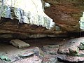
park are over 25 miles (40 km) of hiking trails, rock formations, waterfalls, and recess caves. The trails are open from dawn to dusk, all year round...
20 KB (2,223 words) - 16:33, 11 November 2024

The Moonville Rail-Trail is a ten-mile (16 kilometer) rail-trail in southeast Ohio, located in Vinton and Athens Counties. It is largely embedded in the...
5 KB (432 words) - 20:00, 31 May 2024

Columbus, and on the south by Marble Cliff and Grandview Heights. The Olentangy River and the main campus of the Ohio State University are a short distance...
27 KB (2,755 words) - 13:31, 2 August 2024

05 km2) is water. Galion lies just south of a continental divide. The Olentangy River begins near and runs through Galion, and then winds southward toward...
39 KB (4,325 words) - 22:12, 5 November 2024

cabins, conference center, and lodge. The Buckeye Trail passes around the lake, and the North Country Trail is coincident with the Buckeye in this location...
4 KB (311 words) - 05:58, 1 August 2023

features three principal trails, the one-mile Calico Bush Trail, the two-mile Salt Creek Trail, and the 2.5-mile Pine Ridge Trail. Boating is allowed on...
3 KB (209 words) - 18:21, 6 January 2023


President William Henry Harrison. That year, Squire also brought her to the Olentangy Indian Caverns. She was too afraid to explore them, but found importance...
27 KB (3,225 words) - 01:01, 21 November 2024

art and several parks. The Olentangy River runs through the neighborhood providing access to the Olentangy Recreation Trail, which stretches from downtown...
14 KB (1,537 words) - 08:38, 3 November 2023

Road, & Kinnear to the north, Third Avenue to the south, Kenny Road and Olentangy River Road to the east and Northstar Road to the west. Also sometimes...
16 KB (1,697 words) - 07:16, 11 April 2024
trailhead via a narrow easement. The park's 2.75-mile (4.43 km) trail system includes two loop trails, one of which passes the natural bridge, while the other...
4 KB (265 words) - 14:45, 13 January 2023

Gardner began running in elementary school in the DC area. She attended Olentangy High School in Columbus, Ohio, where she competed for the school's first...
8 KB (816 words) - 23:38, 23 April 2023

named for its steep banks along the Olentangy River, the park's most unique feature. Highbanks also features ten trails, picnic space, a nature center, sledding...
8 KB (694 words) - 05:19, 10 October 2024

features the Wildcat Hollow Trail, a hiking trail just northeast of Burr Oak State Park in Morgan County; the Stone Church Horse Trail in Perry County; the Utah...
15 KB (1,334 words) - 02:07, 5 November 2024