
The Pachaug Trail is a 28-mile (45 km) Connecticut hiking trail and is one of the Blue-Blazed hiking trails maintained by the Connecticut Forest and Park...
14 KB (1,805 words) - 23:21, 30 December 2023

popular hiking trails, maintained by the Connecticut Forest and Park Association, that run through Pachaug State Forest. The Pachaug Trail runs about 30...
9 KB (768 words) - 17:36, 24 September 2023

Association. The trail is located in the towns of Voluntown and Griswold and is almost entirely within the Pachaug State Forest. The Nehantic Trail is a Blue-Blazed...
12 KB (1,658 words) - 16:24, 16 September 2018

Association. The trail is located in the towns of Griswold, Voluntown and Plainfield in eastern Connecticut and is almost entirely within the Pachaug State Forest...
16 KB (2,011 words) - 02:54, 29 December 2022

Blue-Blazed Hiking Trails via the Green Falls Pond Loop connector trail: the Nehantic Trail and Pachaug Trail in Connecticut's Pachaug State Forest. The...
20 KB (2,403 words) - 16:59, 8 August 2024
Leffingwell House Museum Pachaug-Great Meadow Swamp Uncas Leap Heritage Area, Norwich, Connecticut Air Line State Park Trail Beaver Brook State Park,...
9 KB (734 words) - 09:06, 30 July 2024
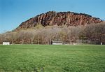
Creek Mount Misery (Washington state) Mount Misery, a rocky hill on the Pachaug Trail, Connecticut Mount Misery, a hill in the town of Auburn, New Hampshire...
2 KB (327 words) - 00:22, 26 March 2024

Farmington Canal Heritage Trail, also known as the New Haven and Northampton Canal Greenway, is an 82-mile (132 km) multi-use rail trail located in Connecticut...
9 KB (990 words) - 21:16, 10 July 2024

State Park Trail is a rail trail and linear state park located in Connecticut. The trail is divided into sections designated South (a 25-mile trail from East...
35 KB (2,902 words) - 21:54, 8 September 2024
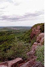
Regicides Trail is a Blue-Blazed hiking trail, about 7 miles (11 km) long, roughly following the edge of a diabase, or traprock, cliff northwest of New...
8 KB (1,016 words) - 11:20, 31 December 2023

The Nipmuck Trail is a Blue-Blazed hiking trail system which meanders through 34.5 miles (55.5 km) of forests in northeast Connecticut. It is maintained...
10 KB (1,102 words) - 15:33, 10 June 2024

The Ives Trail and Greenway is a 20-mile (32 km) hiking trail in the Housatonic Valley Region (also known as Greater Danbury). Its route connects Ridgefield...
4 KB (614 words) - 20:18, 20 May 2023
Mattabesett Trail is a 62-mile (100 km) long, hook-shaped blue-blazed hiking trail in central Connecticut and a part of the New England National Scenic Trail. One...
13 KB (1,465 words) - 19:56, 24 September 2024

Sleeping Giant (Connecticut) (redirect from Sleeping Giant State Park Trails)
over 30 miles (48 km) of hiking trails traverse it including 5 miles (8 km) of the 23-mile (37 km) Quinnipiac Trail. Quinnipiac University is located...
21 KB (2,144 words) - 05:18, 2 September 2024
The Naugatuck Trail is a 6.8-mile (10.9 km) Blue-Blazed hiking trail "system" in the eastern central-lower Naugatuck River Valley in New Haven County,...
13 KB (1,453 words) - 14:56, 10 March 2023

The Aspetuck Valley Trail is a 5.9-mile (9.5 km) Blue-Blazed hiking trail in the Aspetuck River Valley area of Fairfield County in the towns of Newtown...
13 KB (1,625 words) - 20:27, 1 September 2024

The Metacomet Trail is a 62.7-mile (100.9 km) Blue-Blazed hiking trail that traverses the Metacomet Ridge of central Connecticut and is a part of the newly...
29 KB (3,465 words) - 16:48, 5 September 2024

Trail Nipmuck Old Furnace Pachaug Paugussett Peoples Pequot Pine Knob Pomperaug Quinebaug Quinnipiac Ragged Mountain Regicides Risley Pond Loop Trail...
15 KB (1,996 words) - 13:39, 11 October 2024

The Tunxis Trail is a 79-mile (127 km) Blue-Blazed hiking trail "system" that traverses the western ridge of the central Connecticut Valley. The mainline...
17 KB (2,035 words) - 00:34, 28 February 2023

public recreation area located on Hopeville Pond, an impoundment of the Pachaug River, in the town of Griswold, Connecticut. A portion of the 554-acre...
9 KB (840 words) - 02:16, 17 August 2024

The Paugussett Trail is a 14-mile (23 km) Blue-Blazed hiking trail "system" in the lower Housatonic River valley in Fairfield County and, today, is entirely...
21 KB (2,379 words) - 16:32, 1 April 2024

Westwoods Trails is an extensive hiking trail system in Guilford, Connecticut. The trail system has approximately 39 miles (63 km) of trails with features...
5 KB (663 words) - 17:00, 28 April 2024

million restoration and includes a visitors' center and museum, hiking trails, and picnic area. William Gillette's "castle", called Seventh Sister and...
15 KB (1,305 words) - 00:41, 6 October 2024

The 'Hancock Brook Trail' is a 2.8-mile (4.5 km) Blue-Blazed hiking trail Waterville Section of the City of Waterbury in New Haven County close to the...
12 KB (1,419 words) - 11:43, 24 February 2022

Legion State Forest Trails is a system of Blue-Blazed hiking trails in the Pleasant Valley section of Barkhamsted, Connecticut. The trails, which collectively...
9 KB (735 words) - 15:30, 13 April 2021

allow. Events and activities The park offers educational films, guided trail walks, and lectures. Warm-month activities include footprint track casting...
8 KB (692 words) - 21:07, 11 August 2024

McLean Game Refuge (redirect from McLean Game Refuge Trails)
George, a Pequot Indian who became the caretaker of his lands, building the trails and huts throughout the Refuge. George's two sons followed him as caretaker...
7 KB (736 words) - 21:12, 18 June 2024

Macedonia Brook State Park (redirect from Macedonia Brook Trail)
51-site campground, picnic, fish, and hike the blue-blazed Macedonia Ridge Trail, which crosses Cobble Mountain and other peaks. The park's first 1,552 acres...
4 KB (198 words) - 01:55, 20 August 2024

Forest Trails is a system of blue-blazed hiking trails in the Pleasant Valley section of Barkhamsted, Connecticut, United States. The trails, which collectively...
6 KB (838 words) - 23:44, 22 September 2024

41.46°N 73.31°W / 41.46; -73.31 The Lillinonah Trail is a 5.9-mile (9.5 km) Blue-Blazed hiking trail "system" in the lower Housatonic River valley in...
20 KB (2,454 words) - 19:34, 28 May 2024