Picacho Hills is an planned community and census-designated place (CDP) in Doña Ana County, New Mexico, United States. It was first listed as a CDP prior...
4 KB (167 words) - 01:39, 27 May 2024

(or A) Mountain on the east and Picacho Peak on the west side of Las Cruces. The county also includes one of New Mexico's four large lava fields, the Aden...
24 KB (2,177 words) - 20:35, 17 August 2024
Box Canyon, originally known as Picacho Pass, is a canyon in Doña Ana County, New Mexico. Its mouth lies at an elevation of 3,927 feet (1,197 m). Its source...
2 KB (311 words) - 16:16, 8 August 2019
Pechacho or Picacho Station – Located 37 miles from Socatoon Station, 14 miles from Blue Water. Pointer Mountain Station – Located 22 miles from Picacho Station...
13 KB (1,462 words) - 14:53, 5 November 2023
Las Cruces Public Schools (category Education in Doña Ana County, New Mexico)
Las Cruces, Butterfield Park, Doña Ana, Fairacres, Mesilla, Organ, Picacho Hills, Radium Springs, San Pablo, San Ysidro, Tortugas, University Park, and...
5 KB (482 words) - 19:25, 21 July 2024
the towns of Picacho and Tinnie. Near the community of Riverside the river passes through a deep canyon before entering the rolling hills west of Roswell...
5 KB (435 words) - 18:18, 12 May 2023

New Mexico is a state located in the Western United States. New Mexico has several census-designated places (CDPs) which are unincorporated communities...
47 KB (57 words) - 02:42, 28 September 2024
List of mountain ranges of Arizona (section New Mexico)
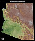
(Hidalgo County), New Mexico, also a Madrean Sky Island Perilla Mountains–Cochise County Phoenix Mountains–Maricopa County Picacho Mountains–Pinal County...
35 KB (2,963 words) - 23:51, 24 September 2024
in New Mexico, along with the Interstate Highway System, and the United States Numbered Highway System, fall under the jurisdiction of the New Mexico Department...
178 KB (553 words) - 04:50, 10 September 2024

Mazatlán (redirect from Mazatlán, Mexico)
activities are livestock, agriculture, and saddlery. It is close to Presa Picachos. A few miles away is the famous Vinata de Los Osuna, a major producer of...
77 KB (9,127 words) - 01:00, 24 September 2024

Sierra Madre Occidental (category Mountain ranges of Mexico)
Madre Occidental along eastern Mexico and the Gulf of Mexico. The range extends from northern Sonora, a state near the Mexico–U.S. border at Arizona, southeast...
89 KB (9,573 words) - 03:27, 14 August 2024

Chuska Mountains (category Mountain ranges of New Mexico)
small, including Crystal, New Mexico, Lukachukai, Arizona, and Toadlena, New Mexico. Trading posts at Crystal and at Two Grey Hills (about 10 km east of Toadlena)...
11 KB (1,275 words) - 19:34, 25 September 2024

East Timor Cristo Rei of Dili in Dili (27 m, 89 ft) Honduras Christ at El Picacho in Tegucigalpa India Imitation statue of Christ the Redeemer at Nellore...
34 KB (2,804 words) - 20:19, 2 September 2024
(1958). "Physiography of the Black Mesa Basin area, Arizona" (PDF). New Mexico Geological Society Field Conference Series. 9: 146–149. Retrieved October...
5 KB (429 words) - 14:57, 19 April 2024
Coatepec Harinas (redirect from Coatepec Harinas, State of Mexico)
Potrero (El Potrero) Colonia Guadalupe Cruz de Piedra Cuentla, El Cedrito El Picacho El Potrerito (El Potrero) El Reynoso El Telar Huayanalco Ixtlahuaca de...
8 KB (552 words) - 06:39, 2 May 2024

Guanajuato (city) (redirect from Guanajuato City, Mexico)
Gregorio. Principal elevations include Santa Rosa, Chichíndaro, Sirena, Bufa Picacho and Bufa Peñón all near the city. Others include La Giganta, El Gigante...
82 KB (9,583 words) - 03:04, 7 September 2024
Nuevo León (redirect from Nuevo Leon, Mexico)
mountain range include the Galeana and Doctor Arroyo plateaus, the Iguana, Picachos, Papagayos, and Santa Clara mountain ranges, and the Pilón, Ascensión,...
83 KB (7,663 words) - 22:46, 26 September 2024
Euskara) Picacho Peak (Arizona, U.S.) (Peak Peak – Spanish) Pinnelhill, Fife, Scotland. Pen (Pictish) and hyll (Old English; x2), both meaning "hill". Pinnacle...
53 KB (5,947 words) - 02:22, 1 October 2024

Altavista (Zacatecas) (category Former populated places in Mexico)
solstices steps in relation to the Sun rising by surrounding hills: Chapín, Pedregoso and Picacho. It is apparent that most of the constructions on this site...
16 KB (2,036 words) - 17:23, 28 September 2023

Aguascalientes (redirect from Aguascalientes (Mexico))
Centro de Aguascalientes, Hidrocálido, La Jornada Aguascalientes, and Picacho Panorama de Aguascalientes. See also articles in the category People from...
44 KB (3,866 words) - 22:54, 26 September 2024

Gold mining in the United States (section New Mexico)
the west bank of the Colorado River were quickly found, including the Picacho and Cargo Muchacho districts. Placer gold deposits were found at San Ysidro...
37 KB (4,607 words) - 11:32, 11 June 2024

Madrean Sky Islands (category Natural history of New Mexico)
ranges in southern and southeastern Arizona, southwestern New Mexico, and northwestern Mexico. The sky islands are surrounded at lower elevations by the...
4 KB (333 words) - 22:58, 19 June 2021
Cerro del Cubilete in Guanajuato, Mexico Cerro de los Ángeles on a hill located in Getafe, Spain Christ at El Picacho in the north area of Tegucigalpa...
8 KB (797 words) - 02:21, 26 September 2024

Mexicable near Mexico City, among others) and elsewhere. Medellín is located in the Aburrá Valley and is surrounded by hills. Many of those hills are home to...
13 KB (1,392 words) - 15:12, 27 June 2024

border with New Mexico; they are a continuation from the west of the Arizona transition zone–Mogollon Rim, with the Rim ending in western New Mexico. The White...
4 KB (239 words) - 15:46, 17 April 2024
Battle of Picacho Pass (1862). The Federal government declared a new U.S. Arizona Territory, consisting of the western half of earlier New Mexico Territory...
164 KB (13,827 words) - 10:23, 26 September 2024

Colorado Desert (category Wikipedia articles incorporating a citation from the New International Encyclopedia)
Bono Salton Sea NWR Indio Hills Palms Anza-Borrego Desert State Park Ocotillo Wells State Vehicular Recreation Area Picacho State Recreation Area Heber...
11 KB (1,144 words) - 19:56, 13 September 2024

Tlalpan (category Boroughs of Mexico City)
the Picacho Highway. Forest fires are a common problem not only in the Bosque de Tlalpan but also in Parque Fuentes Brotantes, Parque Ciudad de Mexico and...
80 KB (10,333 words) - 02:44, 13 August 2024

Joaquin Murrieta (redirect from Mexican Robin Hood)
Includes military reports and news reports from 1846–1931. Joaquín Murrieta, Picacho The Legend of Joaquin Murieta Archived March 3, 2016, at the Wayback Machine...
35 KB (3,846 words) - 17:37, 7 August 2024

Territory, Dakota Territory, Indian Territory (present-day Oklahoma), New Mexico Territory, and Washington Territory), as well as naval engagements. Virginia...
119 KB (731 words) - 15:53, 16 September 2024