
Piz Urlaun is a mountain of the Glarus Alps, located on the border between the Swiss cantons of Glarus and Graubünden. It lies on the ridge between the...
1 KB (65 words) - 19:18, 16 July 2023
Punteglias, south of Piz Urlaun. Retrieved from the Swisstopo topographic maps. The key col is the Fuorcla da Punteglias (2,814 m). Piz Posta Biala on Hikr...
1 KB (62 words) - 16:52, 17 May 2022

Tödi (redirect from Piz Russein)
south-east of the Tödi, bounded to the south by the peaks of Stoc Grond, Piz Urlaun and Bifertenstock, forming the boundary of the two cantons. The last-named...
8 KB (991 words) - 08:24, 16 November 2022
Piz Ner is a mountain of the Glarus Alps, located north of Trun in the canton of Graubünden. It lies in the group south of Piz Urlaun. Piz Ner on Hikr...
1 KB (55 words) - 17:46, 16 April 2022
highest of these are the Piz Giuv (3,096 m) and Piz Nair. The name Crispalt is given to a southern, but secondary, peak of Piz Giuv, measuring 3,070 m...
11 KB (735 words) - 12:17, 20 July 2024

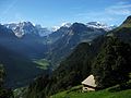
Tödi (also named Piz Russein) with a height of 3,614 metres above sea level. Other high summits overlooking the valley are Piz Urlaun (3,359 m), Düssi...
2 KB (201 words) - 03:47, 10 June 2024

Disentis; in 1793, the Piz Urlaun (11,060 ft), near the Todi; in 1801, Piz Aul (10,250 ft) and Piz Scharboda (10,250 ft); and in 1802, Piz Terri (10,338 ft)...
4 KB (454 words) - 13:38, 16 March 2023

Lukmanier Pass. The high point of the Vorderrhein's drainage basin is the Piz Russein of the Tödi massif of the Glarus Alps at 3,613 metres (11,854 ft)...
10 KB (883 words) - 23:20, 23 August 2024