
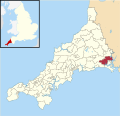
50°23′20″N 4°19′34″W / 50.389°N 4.326°W / 50.389; -4.326 Polbathic (Cornish: Polbarthek) is a small village situated on the A374 Trerulefoot to Torpoint...
2 KB (183 words) - 13:57, 17 September 2023

what is now Plymouth Rd west of Totnes. A386 Plymouth Appledore A387 Polbathic Polperro A388 Saltash bypass Landcross A389 Padstow Lanivet A390 Tavistock...
54 KB (56 words) - 23:53, 18 August 2024

which extends into the neighbouring villages of Tideford, Trerulefoot and Polbathic. Both house and garden are Grade I listed. Originally built as a priory...
6 KB (503 words) - 04:38, 15 March 2024
Street, Plain-an-Gwarry, Playing Place, Plusha, Plushabridge, Point, Polbathic, Polborder, Polbrock, Poldice, Polgear, Polgigga, Polgooth, Polkerris...
45 KB (1,828 words) - 15:35, 27 July 2024

other villages in the historic parish were Tideford, Hessenford, Narkurs, Polbathic, and Bethany, but new ecclesiastical parishes were established in 1834...
14 KB (1,653 words) - 03:33, 19 October 2024

and the town of Torpoint, as well as villages like Antony, Downderry, Polbathic, Portwrinkle and Widegates. There is no precise geographical definition...
5 KB (598 words) - 11:12, 29 May 2024

the River Lynher, through the villages of Antony and Sheviock and on to Polbathic, where the B3249 starts northwards to join the A38, avoiding a low bridge...
5 KB (591 words) - 23:08, 13 February 2023

• coordinates 50°23′17″N 4°17′38″W / 50.38806°N 4.29389°W / 50.38806; -4.29389 Basin features Tributaries • left Polbathic Lake • right Hay Lake...
3 KB (140 words) - 23:38, 7 May 2024
Google Maps. Retrieved 27 September 2010. "Tideford, Saltash, UK to Polbathic, Torpoint, UK". Google Maps. Retrieved 5 October 2010. "Manadon Junction...
172 KB (4,580 words) - 15:06, 6 October 2024
Germans. St Germans and Landulph represented the villages of Trerulefoot, Polbathic, St Germans, Tideford, Landrake, Pillaton, Botusfleming, and the hamlets...
6 KB (163 words) - 09:10, 8 December 2021

south-east Cornwall, United Kingdom, four miles west of St Germans on the A387 Polbathic to Polperro road. The village had a population of 170 at the 2001 census...
3 KB (295 words) - 19:44, 18 December 2023
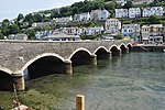
1960s. The road carried by the bridge forms part of the A387 between Polbathic and Polperro. In 1993, the bridge and its six cast iron lamp standards...
12 KB (1,103 words) - 09:02, 4 October 2023
Polbain Highland 58°02′N 5°24′W / 58.03°N 05.40°W / 58.03; -05.40 NB9910 Polbathic Cornwall 50°23′N 4°20′W / 50.38°N 04.33°W / 50.38; -04.33 SX3456 Polbeth...
97 KB (26 words) - 04:27, 24 January 2024