eastern Prince Edward Island. Its southern terminus is at Route 4 in Murray River and its northern terminus is at Route 4 in Montague. The route is entirely...
4 KB (153 words) - 09:30, 20 October 2024

highways in the province of Prince Edward Island. Prince Edward Island relies mostly on arterial roads for major inter-city routes. The only expressway in...
107 KB (2,693 words) - 23:00, 17 February 2024

The Prince Edward Islands are two small uninhabited subantarctic volcanic islands in the southern Indian Ocean that are administered by South Africa....
51 KB (4,534 words) - 09:59, 17 April 2025
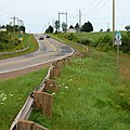
Route 1 is a 120-kilometre (75 mi) long provincial highway that serves as the Prince Edward Island section of the Trans-Canada Highway. Route 1 traverses...
19 KB (823 words) - 02:47, 8 March 2025

Queens County is a county in the province of Prince Edward Island, Canada. It is the largest county in the province by population with 89,770 (2021) and...
12 KB (617 words) - 00:07, 15 January 2025

Prince County is located in western Prince Edward Island, Canada. The county's defining geographic feature is Malpeque Bay, a sub-basin of the Gulf of...
11 KB (512 words) - 21:02, 7 August 2024

Prince County, Prince Edward Island. It is the second largest city in the province and the primary service centre for the western part of the island....
41 KB (2,642 words) - 04:52, 24 April 2025

Prince Edward Island is an island province of Canada. While it is the smallest province by land area and population, it is the most densely populated...
125 KB (11,764 words) - 04:06, 28 April 2025

The Prince Edward Island Railway (PEIR) was a historic Canadian railway in Prince Edward Island (PEI). The railway ran tip-to-tip on the island, from...
29 KB (2,875 words) - 20:28, 8 February 2025

Route 2, also known as Veterans Memorial Highway and the All Weather Highway, is the longest highway in the province of Prince Edward Island, Canada, at...
22 KB (547 words) - 00:23, 5 March 2025
Route 225 is a 33.4-kilometre (20.8 mi), two-lane, uncontrolled-access, secondary highway in central Prince Edward Island. Route 225 passes through the...
5 KB (152 words) - 21:04, 7 December 2024
Route 19 is a secondary highway, that runs along the shoreline of the Northumberland Strait in Queens County, Prince Edward Island, Canada. There are two...
3 KB (148 words) - 09:24, 20 October 2024
O'Leary is a village located in Prince County, Prince Edward Island, about 60 kilometers west of Summerside. Its population in the 2021 Canadian Census...
17 KB (926 words) - 21:36, 26 April 2025
Route 4 is a 63 km (39 mi) long, two-lane uncontrolled access secondary highway in eastern Prince Edward Island, Canada. In runs east from the Trans-Canada...
9 KB (251 words) - 02:50, 8 March 2025
Highway 17 British Columbia Highway 17A Manitoba Highway 17 Winnipeg Route 17 New Brunswick Route 17 Ontario Highway 17 Prince Edward Island Route 17 Saskatchewan...
10 KB (732 words) - 15:45, 27 August 2024
Greenmount Road, labelled Route 153, is a 2-lane collector highway in western Prince County, Prince Edward Island, Canada. It is between the communities...
4 KB (331 words) - 09:26, 20 October 2024
Prince Edward Island Route 7 is a secondary highway in central Prince Edward Island. The short connecting route begins at an intersection with Route 2...
3 KB (96 words) - 14:11, 25 August 2022
Ascension Road, labelled Route 160, is a 2-lane collector highway in western Prince County, Prince Edward Island, Canada. It is located 2 miles (3.2 km)...
3 KB (345 words) - 12:08, 12 April 2023

Mary. He was created Prince of Wales on his 16th birthday, seven weeks after his father succeeded as king. As a young man, Edward served in the British...
103 KB (11,250 words) - 00:20, 22 April 2025
Route 1A is a 20-kilometre (12 mi) long provincial highway in central Prince Edward Island. The route is a spur route of the Route 1 which connects the...
5 KB (169 words) - 02:49, 8 March 2025
Route 20 is a 32.3 km (20.1 mi), two-lane, uncontrolled-access, secondary highway in Prince Edward Island. Its western terminus is at Route 2 and Route...
3 KB (114 words) - 09:33, 20 October 2024
Route 3 is a 33 km (21 mi) long, two-lane uncontrolled access secondary highway in Prince Edward Island, Canada. Its maximum speed limit is 90 km/h (55 mph)...
5 KB (109 words) - 02:49, 8 March 2025
Route 22 is a 28.6 km (17.8 mi), two-lane, uncontrolled-access, secondary highway in eastern Prince Edward Island. Its southern terminus is at Route 210...
3 KB (102 words) - 09:32, 20 October 2024
0360278 Pridham Road, labelled Route 154, is a 2-lane collector highway in western Prince County, Prince Edward Island, Canada. It is near the town of...
3 KB (230 words) - 09:25, 20 October 2024
Road (see below), is a 2-lane collector highway in western Prince County, Prince Edward Island, Canada. It is located 0–4 miles SW of the community of Tignish...
3 KB (326 words) - 15:17, 15 July 2024

Prince Edward Island Route 6 is a secondary highway in central Prince Edward Island. Route 6 begins in Kensington at the junction of Routes 2 and 20,...
9 KB (167 words) - 09:27, 20 October 2024

Wood Islands is a rural farming and fishing community located in southeastern Queens County, Prince Edward Island on the Northumberland Strait. It takes...
33 KB (4,833 words) - 03:24, 11 December 2023
or Peterville Road, labelled Route 159, is a 2-lane collector highway in western Prince County, Prince Edward Island, Canada. It is near the community...
3 KB (270 words) - 11:01, 20 December 2024
Route 12 is a 112 km (70 mi), two-lane, uncontrolled-access, secondary highway in western Prince Edward Island, Canada. Its southern terminus is at Route...
7 KB (181 words) - 02:50, 8 March 2025

Palmer Road, labelled Route 156, is a 2-lane collector highway in western Prince County, Prince Edward Island, Canada. It is between the communities of...
4 KB (365 words) - 15:18, 15 July 2024