
The Pskem (Russian: Пскем) or Piskom (Uzbek: Piskom) is a river of Tashkent Region in Uzbekistan in the Pskem Mountains. The river runs for 149 km (93 mi)...
2 KB (220 words) - 12:14, 14 February 2022
The Pskem Mountain Range (Russian: Пскемский хребет, Pskemskiy Khrebet) or Piskom Mountains, is a mountain range located within the west Tien Shan range...
2 KB (182 words) - 12:22, 24 October 2022
2015-08-20. "Componentes de la Mina- Nuestras Operaciones - Antamina". "Pskem GES qurilishi: GESning 1-to'siq darvozasi yopilishi munosabati bilan tadbir...
46 KB (554 words) - 10:38, 22 August 2024

northern part of Tashkent Region, Uzbekistan, separating Ugam (north), Pskem (east), and Chatkal (south) ranges. The reservoir was created by erecting...
3 KB (286 words) - 20:38, 16 August 2024

of the Adelung Pskem ridge with an altitude of 4301 meters. In the second place in height, the mountain is another peak of the Pskem ridge - Beshtor...
8 KB (686 words) - 01:56, 14 August 2023
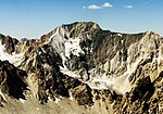
Mount Adelung (Russian: Гора Аделунга) is the highest peak in Pskem Mountains (Russian: Пскемский хребет) in the extreme north-east of the Tashkent Region...
3 KB (235 words) - 09:49, 26 July 2024
formerly Peak of the 22nd Congress of the Communist Party Gissar Range Pskem Range Zeravshan Range Talas Ala-Too Range Chatkal Range Ugam Range Turkestan...
642 bytes (44 words) - 20:48, 1 September 2022
German grammarian and philologist Mount Adelung, the highest peak in the Pskem Range in extreme north-east Uzbekistan's Tashkent Province This page lists...
505 bytes (87 words) - 19:58, 13 May 2021

(right). The river is formed at the confluence of the rivers Chatkal and Pskem, which form the Lake Charvak reservoir. It flows through about 30 km of...
3 KB (177 words) - 01:29, 19 November 2022

western end extends into Kazakhstan, and its south-western end joins the Pskem Mountains and Ugam Range of Uzbekistan. Its eastern end joins the Kirgiz...
2 KB (198 words) - 08:17, 28 July 2023

Mount Beshtor (Russian: гора Бештор, also Беш-Тёр) rises to 4,299 m in Pskem Range in the north-eastern tip of Uzbekistan's Tashkent Province. Located...
2 KB (100 words) - 09:50, 26 July 2024

Uzbekistan. It originates in the Pskem Range of the Tianshan Mountains and flows into the river Pskem, at the bridge over the Pskem near the water level of Lake...
1 KB (89 words) - 12:14, 14 February 2022
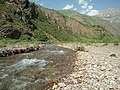
Uzbekistan. The Pskem Range runs parallel to the Ugam Range to the south, with the Pskem River valley separating the ranges. The Pskem enters the Charvak...
2 KB (257 words) - 22:11, 26 June 2023

territory wedged between Kazakhstan and Kyrgyzstan; the border traverses the Pskem Mountains, with much of this area being taken up by a series of national...
18 KB (2,257 words) - 03:13, 15 June 2024
Tien Shan). Practically Bog-i Ston nestles among verdure ashore the river Pskem where it flows into the Charvak Reservoir. "Bog-i Ston" is Tajik and Uzbek...
6 KB (662 words) - 20:36, 10 April 2024
built in 1970. The lake Charvak reservoir was formed by the rivers of Mount Pskem, Kok Su and Chatkal. On the land of the lake there were formerly some settlements...
3 KB (246 words) - 22:05, 26 June 2023
2534 21 6 Kulun Range 30 10 Kuramy Range 3769 30 25 Kuturgan Range 24 5 Pskem Range 4395 120 20 Sary Jon Range 24 5 Seruyun Dobo Range 2469 30 12 Suuk...
9 KB (74 words) - 12:09, 7 June 2024

season progresses. The range of the Menzbier's marmot is split in two by the Pskem River and its valley. Although the two populations are very similar in their...
4 KB (402 words) - 14:34, 14 October 2023
fossils. It is a shallow karst cave near the junction of the Chatkal and Pskem Rivers at the southwestern end of the Talassky Alatau Range in the Tien...
14 KB (1,597 words) - 13:35, 11 April 2023

occupies high-altitude Chatkal valley limited by Talas Ala-Too from north, Pskem Range from north-west and west, and Chatkal Range from south-east. In addition...
7 KB (529 words) - 04:42, 14 August 2024
The Chandalash (Kyrgyz: Чандалаш) is a river in the Pskem Mountains of Chatkal District in Jalal-Abad Region in western Kyrgyzstan. The river is formed...
3 KB (153 words) - 17:20, 28 March 2024