
Quemahoning Township is a township in Somerset County, Pennsylvania, United States. The population was 1,838 at the 2020 census. It is part of the Johnstown...
8 KB (741 words) - 12:33, 10 June 2024
Quemahoning Reservoir, also known to locals as The Que, is created by the Quemahoning Dam, located on Quemahoning Creek on the border of Quemahoning Township...
8 KB (602 words) - 18:02, 21 July 2024
state of Pennsylvania is divided into 1,547 townships in 67 counties. For listings of townships in individual counties, see the category Townships in Pennsylvania...
159 KB (107 words) - 05:08, 4 September 2024

is water. Conemaugh Township is bordered by Jenner Township to the southwest, Quemahoning Township to the southeast, Paint Township to the east, and Cambria...
7 KB (589 words) - 00:43, 10 June 2024

Milford Township and a southern portion of Quemahoning Township in 1796. Jefferson Township was separated from Somerset Township in 1847. Other townships and...
9 KB (695 words) - 21:21, 18 July 2024

intersecting Quemahoning Creek at Kickenapaulin's Town, a rather substantial Indian settlement, the site of which now lies under the waters of the Quemahoning Reservoir...
12 KB (1,302 words) - 08:57, 6 October 2024

Cities (see cities list) Boroughs (see boroughs list) Townships (see townships list) Pennsylvania also contains many unincorporated communities with often...
251 KB (323 words) - 13:55, 4 October 2024

Stonycreek Township was settled in 1762. Most old records call it Stony Creek. The Township was incorporated in 1792 from portions of Quemahoning Township as...
12 KB (1,181 words) - 18:16, 31 August 2024
Shade and Quemahoning Townships, was first settled in 1836 and was incorporated in 1896. According to the United States Census Bureau, the township has a...
12 KB (1,393 words) - 12:39, 10 June 2024

the northwest, Stonycreek River, Shade Creek, and Quemahoning Creek (which flows into the Quemahoning Reservoir) are tributaries of the Conemaugh River...
45 KB (3,173 words) - 18:40, 11 September 2024

Hooversville sits on the eastern edge of Quemahoning Township, along its border with Shade Township. Pennsylvania Route 403 runs through Hooversville and...
9 KB (715 words) - 23:28, 13 December 2023

Lincoln Township is bordered by Jenner Township to the northeast, Quemahoning Township to the east, Somerset Township to the southeast, Jefferson Township to...
6 KB (450 words) - 01:06, 10 June 2024
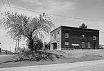
Trostletown Bridge (category Covered bridges in Somerset County, Pennsylvania)
Trostletown Bridge is a historic covered bridge in Quemahoning Township, Somerset County, Pennsylvania. It was built in 1845, and is a 104-foot-long (32 m)...
3 KB (152 words) - 23:22, 24 May 2024
Pennsylvania Railroad tunnels could be used for the roadway. The Allegheny Mountain Tunnel was in too poor a condition for use, and the Quemahoning and...
219 KB (22,480 words) - 20:34, 17 October 2024

is bordered by Ogle Township to the east, Shade Township to the south, Quemahoning Township to the southwest, Conemaugh Township to the west, and Cambria...
8 KB (714 words) - 01:13, 10 June 2024
Petersburg, Pennsylvania, surrounded by Richland Township Stoystown, Pennsylvania, surrounded by Quemahoning Township Strattanville, Pennsylvania, surrounded...
57 KB (4,113 words) - 23:29, 24 August 2024

-78.95389 (40.102753, -78.953869). The borough is surrounded by Quemahoning Township. According to the United States Census Bureau, the borough has a...
11 KB (1,023 words) - 15:25, 19 March 2024

in Quemahoning Township. The northern terminus is at US 119 near Marion Center. PA 403 begins at an intersection with US 30 in Quemahoning Township, Somerset...
18 KB (1,541 words) - 14:44, 17 February 2023

Lincoln Township Lower Turkeyfoot Township Meyersdale Middlecreek Township Milford Township New Baltimore New Centerville Northampton Township Quemahoning Township...
5 KB (135 words) - 03:15, 21 December 2023

approaching its centenary and currently serves the two surrounding townships (Jenner and Quemahoning) and three boroughs (Jennerstown, Stoystown and Hooversville)...
22 KB (2,295 words) - 15:15, 29 July 2024
(abandoned), constructed 1838 Quemahoning Mountain Tunnel, Pittsburgh, Westmoreland and Somerset Railroad, omitted from the Pennsylvania Turnpike Radebaugh Tunnel...
27 KB (1,798 words) - 12:40, 15 April 2024

passes through woodland and crosses Quemahoning Creek before turning northeast. The road crosses back into Jenner Township and continues through a mix of farm...
10 KB (839 words) - 02:35, 25 April 2024

runs through the residential community of Friedens. The road enters Quemahoning Township and runs through farmland with some woods and homes, turning north...
13 KB (1,029 words) - 14:22, 13 February 2023
The following railroads operate in the U.S. state of Pennsylvania. Aliquippa and Ohio River Railroad (AOR) Genesee & Wyoming Allegheny Valley Railroad...
135 KB (2,081 words) - 05:30, 23 September 2024

(US 30) is a U.S. Highway that runs east–west across the southern part of Pennsylvania, passing through Pittsburgh and Philadelphia on its way from the West...
124 KB (10,733 words) - 11:55, 29 September 2024

Bens Creek Paint Creek Shade Creek Clear Shade Creek Dark Shade Creek Quemahoning Creek Glade Run Crooked Creek Plum Creek North Branch Plum Creek South...
73 KB (4,258 words) - 01:35, 3 October 2024

Newberry and Conewago townships". Pennsylvania Department of Transportation. November 30, 2018. Retrieved November 30, 2018. Pennsylvania Department of Transportation...
347 KB (2,796 words) - 03:13, 15 September 2024
Quecreek Mine rescue (category 2002 in Pennsylvania)
Quecreek Mine on the western flank of the anticline. The mine was opened by Quemahoning Creek Coal Company in 1913 as Quecreek No. 2 mine. Saxman Coal and Coke...
26 KB (3,740 words) - 22:07, 16 September 2024

the National Register of Historic Places listings in Somerset County, Pennsylvania. This is intended to be a complete list of the properties and districts...
14 KB (298 words) - 23:29, 18 December 2023
communities, counties, and other recognized places in the U.S. state of Pennsylvania also includes information on the number and names of counties in which...
39 KB (44 words) - 05:06, 4 September 2024